3-dimensional interactive image modeling system

Inactive Publication Date: 2008-11-25
IMAGELINKS
View PDF6 Cites 88 Cited by
  • Summary
  • Abstract
  • Description
  • Claims
  • Application Information

AI Technical Summary

Benefits of technology

[0007]A system and method for generating custom geospatial information maps and precision corrected images allows realtime interactive production of a desired output image by incorporating user selectable parameters that define various image synthesizing operations. A graphical user interface allows a user to specify parameters that define the desired output image via a remote computing device over a public access network such as the Internet. The parameters define image synthesizing operations such as area, projection, datum, fusion, masking, blending, mosaicking

Problems solved by technology

The synthesizing operations typically require significant manual efforts, and require substantial time and computational resources to compute.
Accordingly, the desired output images may only be gathered periodically, must anticipate a substantial time delay, and require

Method used


Image

  • 3-dimensional interactive image modeling system
  • 3-dimensional interactive image modeling system
  • 3-dimensional interactive image modeling system

Examples


Embodiment Construction

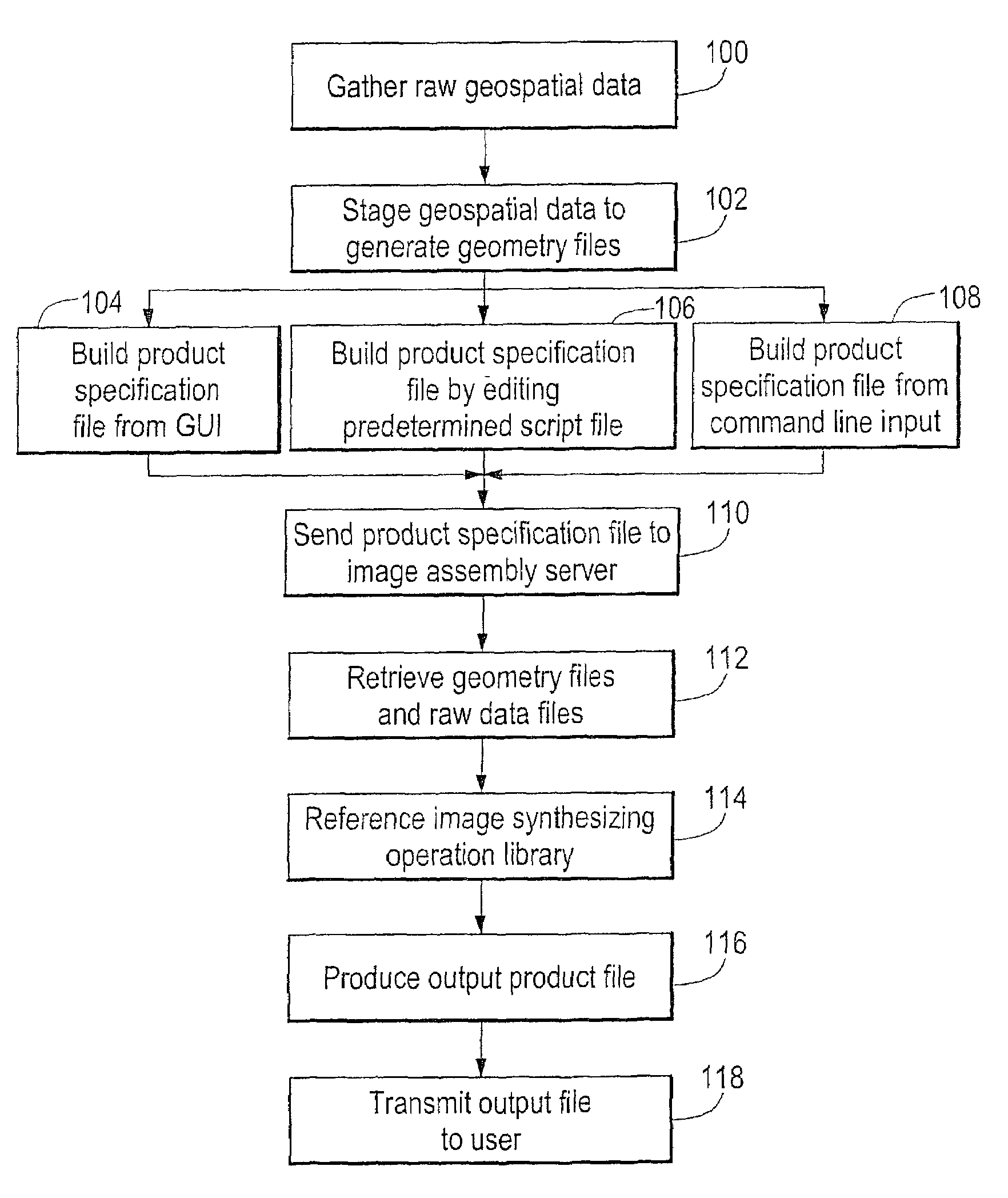
[0022]A description of preferred embodiments of the invention follows.

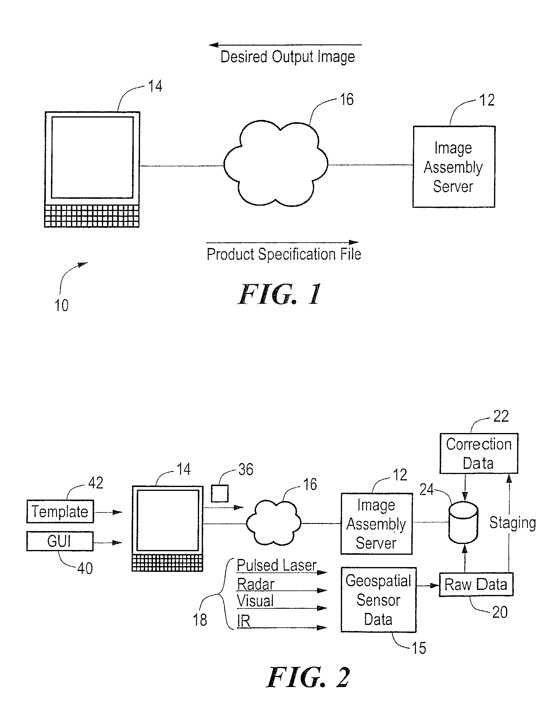
[0023]FIG. 1 shows a block context diagram of the interactive image modeling system 10 as described herein. An image assembly server 12 is in communication with a user computing device 14 such as a PC via a public access network 16. The user computing device 14 is operable to send requests for a desired output image to the image assembly server 12. The image assembly server is responsive to the requests for a desired output image, and sends the desired output image to the user computing device 14 via the public access network 16.

[0024]FIG. 2 shows the system depicted in FIG. 1 in greater detail. Referring to FIG. 2, geospatial sensor data 15 is gathered from a variety of sensor data mediums 18, such as optical or visual, infrared (IR), radar, and pulsed laser, and may be indicative of data sets such as vegetative indexes, flood plane classifications, population density maps, and spectral imagery. Gathering the geo...


PUM


Abstract

A system and method for generating custom geospatial information maps and precision corrected images allows real-time interactive production of a desired output image by incorporating user selectable parameters that define various image synthesizing operations. A graphical user interface allows a user to specify parameters that define the desired output image via a remote computing device over a public access network such as the Internet. The parameters define image synthesizing operations such as area, projection, datum, fusion, masking, blending, mosaiking, resampling, and others. The desired output image is processed by an image assembly server according to the parameters and a variety of geospatial image data sources, and electronically delivered to a user via a public access network. The geospatial information may also be correlated with non-georeferenced data such that relevant associations between non-georeferenced data and the geospatial data are integrated in the output information product.

Description

RELATED APPLICATIONS[0001]This application is a continuation-in-part of U.S. application Ser. No. 09 / 640,135, filed Aug. 16, 2000, now U.S. Pat. No. 6,484,101. The entire teachings of the above application(s) are incorporated herein by reference.BACKGROUND OF THE INVENTION[0002]Geospatial image data is often used to generate a map of a geographical area to denote a variety of geographic features. Such geospatial image data is gathered by a variety of techniques, such as via satellites and aircraft, and encompasses data gathered by a variety of sensor mediums, such as optical, radar, infrared, laser, and others. Often, the geospatial image data must be processed through mathematical synthesizing operations to obtain a desired output image. The synthesizing operations typically require significant manual efforts, and require substantial time and computational resources to compute. Accordingly, the desired output images may only be gathered periodically, must anticipate a substantial t...

Claims


Application Information

Patent Timeline
IPC IPC(8): G01V3/38G06K9/03G06F19/00G06T17/05
CPCG06T17/05
Inventor MELERO, KENNETHSHIBLA, DOUGLAS W.LUCAS, MARK R.
Owner IMAGELINKS
Why Eureka
Try Eureka