The difficulty with nearly all mapping and navigational technology today is that the underlying assumptions used to generate the representation of the map are based on an antiquated navigational representation system.
Ultimately, because of the difficulty and cost associated with the production of maps, the principal purpose for maps was to represent land boundaries and other non-road related land features.
Roads, on the other hand, were few and far between and had little direct monetary value, other than the toll fees they generated for the owners of the land they passed through.
Furthermore, at that time most roads were mere narrow dirt pathways.
Rain, snow, slides, horses' hoofs, and cart wheels continuously damaged the roads, necessitating frequent redirecting and relocating.
Consequently, maps were notoriously unreliable when it came to depicting roads.
The difficulty is that relatively little has changed in the way that roads are represented on present day maps.
They cannot afford to spend much time looking out the window or at information related to the landmass, lest they be late to where they are going, or worse, get into an accident.
The difficulty is that whenever geographic features and feature classes are represented on a communication medium, e.g. in print, on a computer display monitor, or on a TV set monitor, geometric generalization necessarily takes place.
The need for generalization, such as for example, the simplification of the shapes of displayed figures, exaggeration of a figure's size, displacement of a figure relative to its actual location, and removal of a figure altogether introduce additional limitations to cartographic representation.
This problem becomes further amplified when a low-resolution display device is utilized to display and print maps.
However, while these perspective-style maps are more attractive than their non-perspective counterparts, this style of representation is not necessarily better for navigating because the images depicted still do not represent the typical images travelers see when navigating in real life.
Accordingly, these perspective-enhanced maps (often referred to as “3-D”) do not offer a significant cognitive improvement.
Generally, today's pre-printed maps present a series of problems.
Regardless of the current direction of travel, pre-printed maps are oriented to show North at the top, thus making it difficult to get orientated when traveling in any direction other than a Northerly direction.
When these maps are rotated to match the user's actual heading, their labels end up upside down, at an angle, or sideways, making the labels difficult to read, especially since typically they are shown in small fonts.
Further, the conventional maps are typically large in size and made of thin paper, and thus are difficult to hold while walking, driving, or while outdoors in inclement weather.
Their small print and the multitude of text, lines, symbols and graphics all crowded together makes them difficult to read and understand, especially by people with bad eyesight.
They are also hard to orient in the direction of travel without a compass, a task that is particularly difficult for untrained users.
Retail outlets may not carry the latest version of maps that cover regions beyond the local area of the retail outlet, a problem that is not readily apparent to the buyers.
While this makes the individual maps easier to handle, map books introduce their own problems.
Most importantly, it is difficult to follow a planned travel route that spans several pages within the book.
In addition, map books can be rather heavy and cumbersome to hold while looking for the right map.
Finally, map books are rather expensive, typically costing between $30 and $40 each and can be difficult to find in stores located outside of the geographic areas covered by their maps.
Since compasses on their own do not give the user enough information to travel from one point to another, a traveler must use a compass in conjunction with a map, wherein such usage requires some level of training and practice.
Further, because compasses are magnetic devices, their accuracy can be severely affected by proximity to ferrous metals and by physical location.
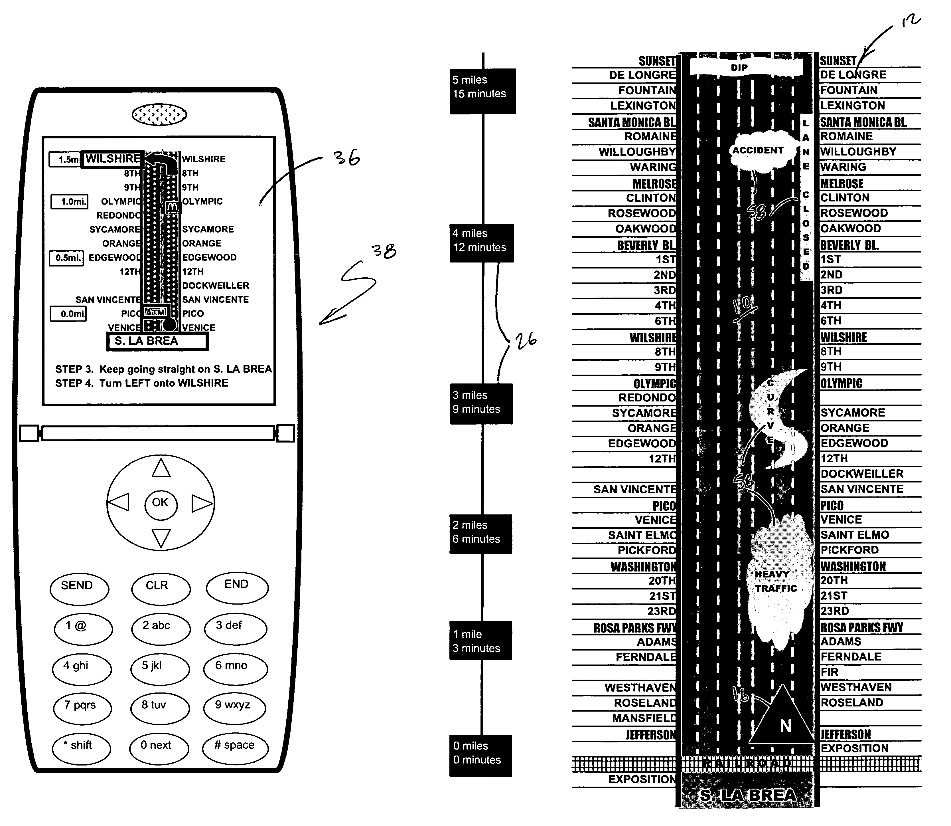
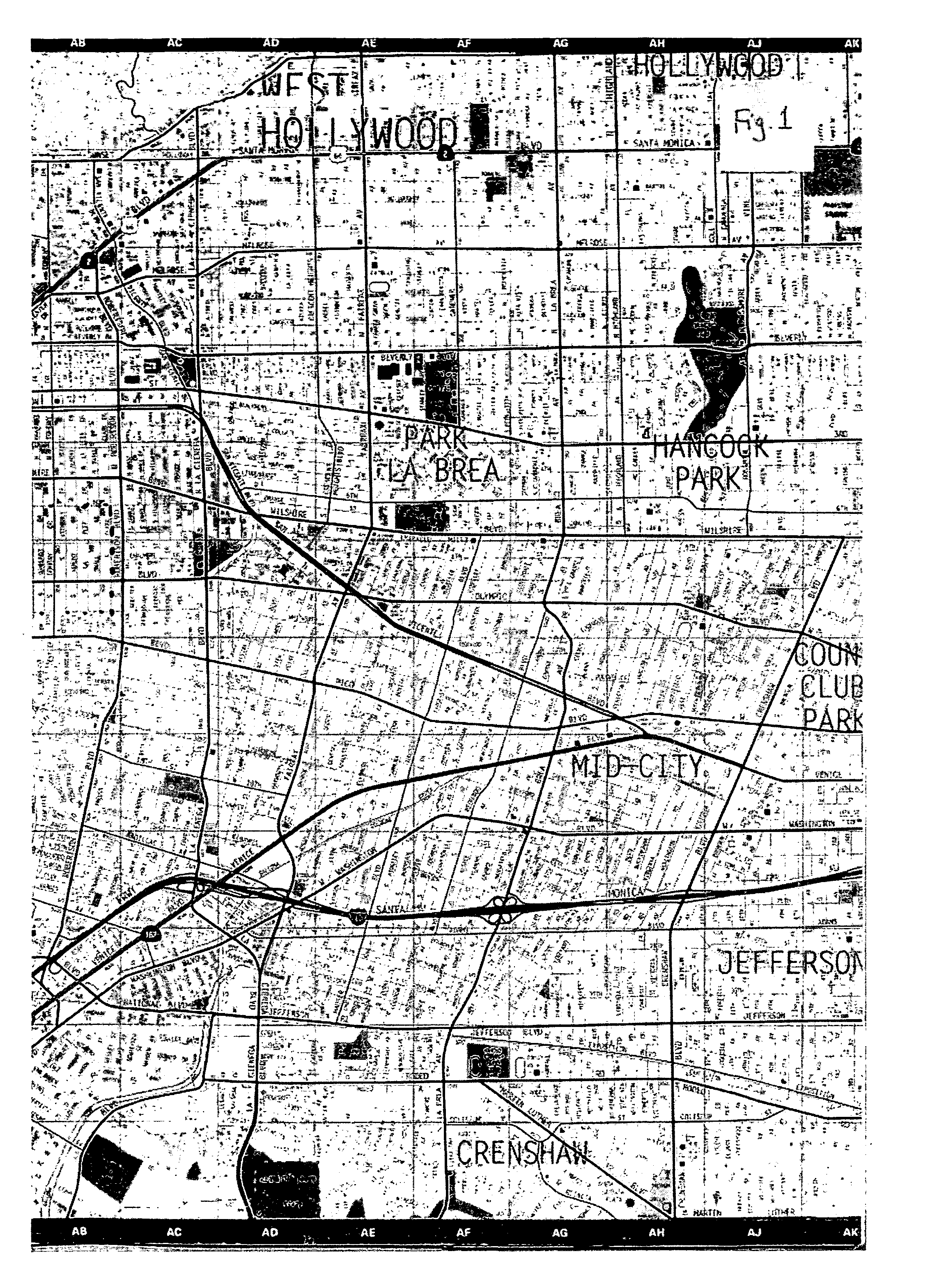
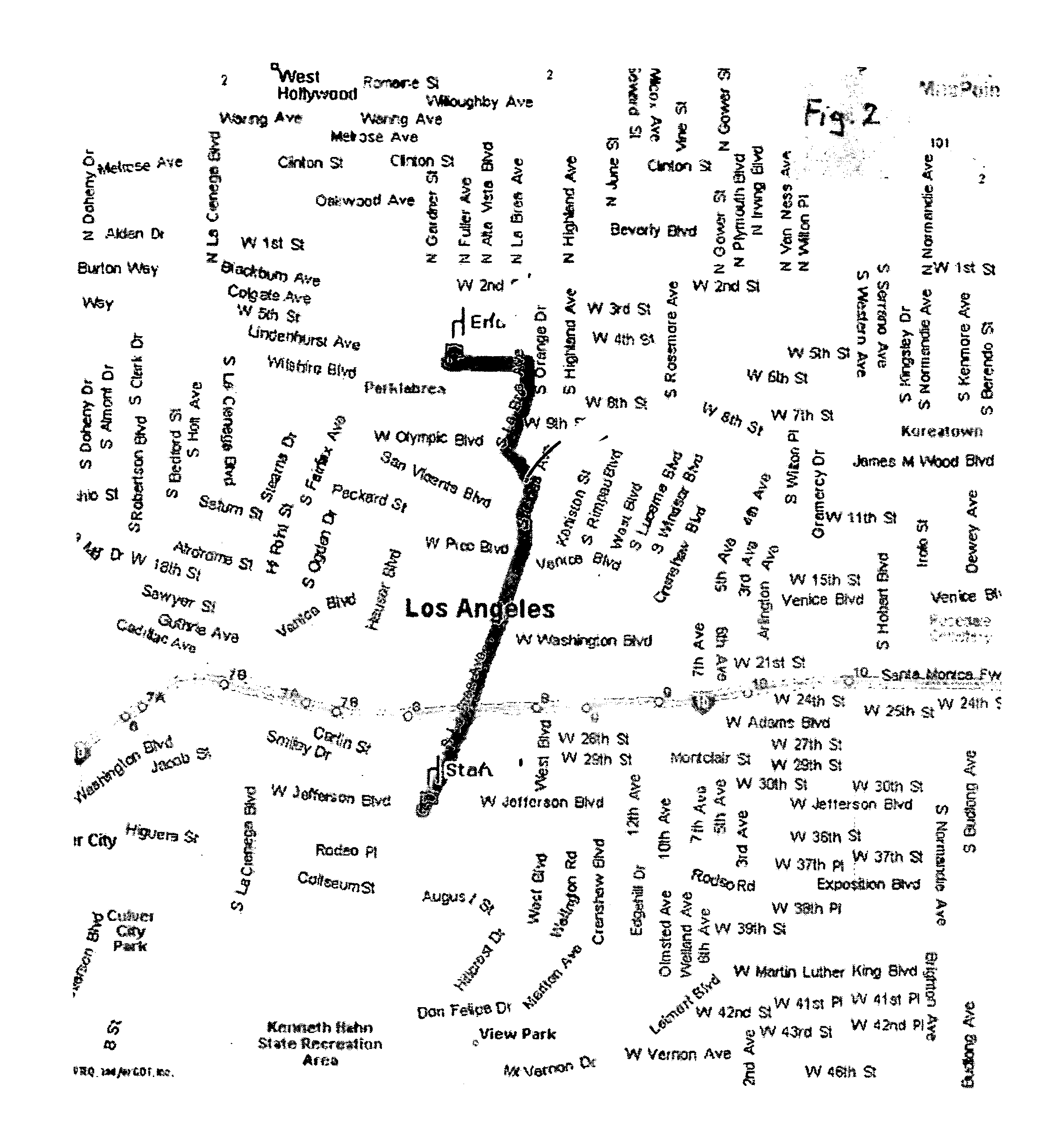
However, computer maps also have several problems. FIG. 2 for example is a conventional map of a complete trip produced using the service available at www.mappoint.com and FIG. 3 is a “LineDrive” format map of the same trip as depicted in FIG. 2 produced using the service available at www.mappoint.com.
The primary problem with today's computer maps is their low-resolution.
When displaying a map formed from a large array of pixels on a computer monitor, many of the features and text may become illegible or disappear entirely.
As a result, most computer generated cartographic maps are difficult, if not impossible, to read and use effectively when displayed on the monitors of small form devices such as palmtop computers, personal digital assistants (PDAs), GPS-based systems, and mobile telephones.
As with all of the previously discussed navigational systems, GPS-based systems also have a number of problems associated with them.
Since GPS-based devices contain several electronic and mechanical components, extensive software, and very large databases depicting cartographic map representations that require constant updating in the field, these systems typically cost over $500 (in 2005).
Due to space constraints, most of the installed displays are up to twenty times smaller than typical computer monitors, making it difficult to show any information other than the most basic, omitting much of the information critical for navigating, such as most of the roads.
This problem is compounded by the fact that the resolution of the displays is relatively low, making it practically impossible to read small text and graphics from the driver's seat, while maintaining a safe driving position.
Accordingly, unless the GPS-based device provides audible voice turn-by-turn instructions, GPS-based systems are of limited help while engaged in other attention-intensive activities such as driving.
Further limiting the usefulness of GPS-based navigation is the fact that some information is inaccurate due to the delay between the time the data is captured in the field and the time it is updated on the users' display.
In addition, information about intervening intersections and surrounding areas around the programmed route is typically left out or is not available.
This creates anxiety for the user and is a major cause of cognitive overload.
Finally, GPS systems do not provide much assistance for users that are not traveling to a precisely-defined destination or address.
Ultimately, the problem with all of these maps and devices is grounded in the cartographic representation that they utilize to define spatial relationships for the user.
In each case, the chosen user interface makes it difficult for the user to employ the navigational aid in a manner that is truly helpful.
The points, arcs, and polygons of cartographic maps have no counterparts in the real world, and thus, most people have difficulty reading maps because they simply cannot imagine in their mind's eye something that they have not personally experienced.
This causes the human brain to fight and block the cartographic maps' attempts to represent space.
Cartographers have not consulted with specialists in ergonomics or experts in mass-media communications to assist them in confronting and resolving problems of human perception when attempting to understand and utilize cartographic representations.
Due to the general unfamiliarity and discomfort most users have with the spatial representations that are used in cartographic maps, reading and interpreting such maps requires a great deal of mental and sensory activity.
A user must use scales to convert distances and areas, they must rotate images, they must read very small letters, symbols and numbers, and they must be able to track thin lines that weave in and out, all of which is made more difficult because the text and graphics (e.g. points, arcs, polygons, logos, icons) are usually densely packed together into small areas.
The perspective images generated may not be familiar to users, as they do not represent the actual images they see when they are within sight of roads or exit lanes in real life.
All of these activities take away time and attention from the main tasks of traveling, such as driving, riding, running, walking, and sightseeing.
Cognitive load research has shown that short-term memory is limited in the number of elements it can contain simultaneously.
As a result, in the presence of any distractions, task performance that depends on the use of short-term memory quickly starts to decay.
The price of the high cognitive load associated with reading and interpreting maps is that the great majority of people have difficulty using maps, especially while performing other tasks.
Because of the built-in cognitive overload of these systems, many information and entertainment products and services are impractical to use in conjunction with them.
Thus, major commercial opportunities are missed, technological synergy is squandered, and users continue to have navigation difficulties.
In addition to consuming a large amount of short-term recall capacity, most navigational aids base their instructions to users on numerical information such as distance and time.
This presents a series of problems.
Second, since distances are hard to measure on maps, the numbers used may be inaccurate.
Third, some people travel faster and others travel slower.
Finally, numeric reckoning is only satisfactory for about half of the general population.
Numeric reckoning is a left-brain activity and thus it is not a satisfactory communication method for right-brain thinkers.
Right brain thinkers cannot effectively visualize how long a distance is, or estimate how long it takes to travel that distance.
Unfortunately, this is not an easy feat to accomplish using today's navigational aids, given the typically small size of their maps' text and graphics, and the paucity of landmarks shown.

