Hybrid INS/GNSS system with integrity monitoring and method for integrity monitoring

a hybrid ins/gnss and integrity monitoring technology, applied in active radio relay systems, navigation instruments, instruments, etc., can solve the problems of variable precision, satellite data may be erroneous, and the control of sensor defects represents a very significant proportion of the cost of inertial reference systems. to achieve the effect of improving the accuracy of position measuremen

Active Publication Date: 2010-05-04
THALES SA
View PDF19 Cites 23 Cited by
  • Summary
  • Abstract
  • Description
  • Claims
  • Application Information

AI Technical Summary

Benefits of technology

[0016]In one aspect of the present invention remedies the drawbacks of the known solutions presented above and to improve the precision of the position measurement by using hybrid corrections delivered by a Kalman filter receiving signals from all the tracked visible satellites.

Problems solved by technology

The control of the sensor defects represents a very significant proportion of the cost of the inertial reference system.
The information is furthermore of variable precision, dependent on the geometry of the constellation on which the triangulation is based, and noisy since it relies on the reception of signals of very low levels originating from distant satellites having a low transmission power.
Furthermore, the satellite data may be erroneous as a consequence of faults affecting the satellites.
However, the RAIM algorithm, linked purely to the satellite based locating system, is not applicable to the monitoring of location data arising from a hybrid (INS / GNSS) system and can detect only certain types of faults in a given time.
When the inertial defects are too significant or when the duration of the flight is long, the linearization of the equations governing the evolution of the inertial model integrated within the Kalman filter is no longer valid.
With a closed-loop INS / GNSS system where the location resolved by the GNSS receiver is used to readjust the information originating from the inertial reference system, it is necessary to pay particular attention to the defects affecting the information provided by the satellites since the receiver which receives them will propagate these defects to the inertial reference system, giving rise to poor readjustment of said inertial reference system.
The problem arises in a particularly critical manner for ensuring the integrity of an INS / GPS hybrid location data.

Method used


Image

  • Hybrid INS/GNSS system with integrity monitoring and method for integrity monitoring
  • Hybrid INS/GNSS system with integrity monitoring and method for integrity monitoring
  • Hybrid INS/GNSS system with integrity monitoring and method for integrity monitoring

Examples


Embodiment Construction

[0028]Across the figures, the same elements are tagged by the same references.

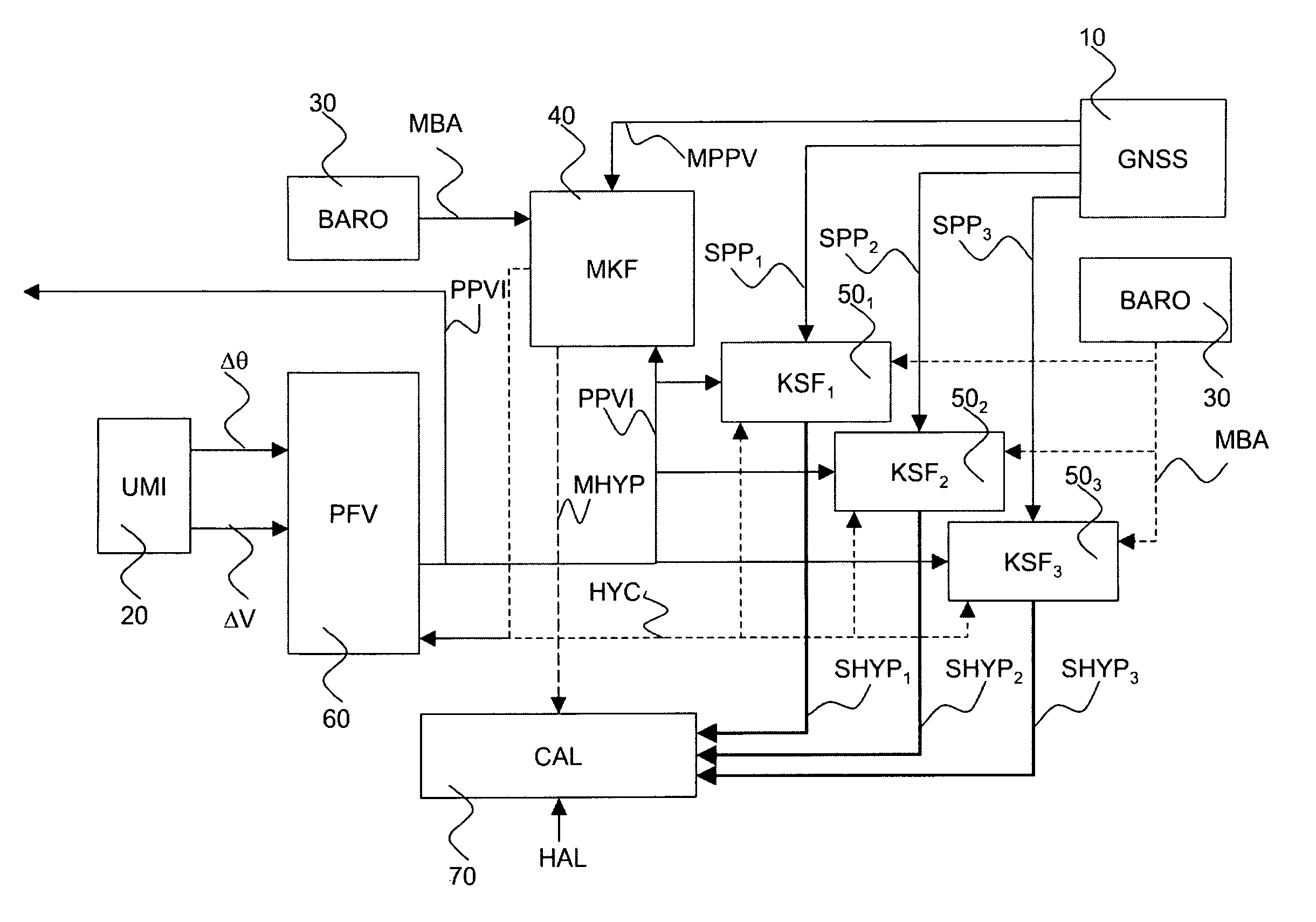
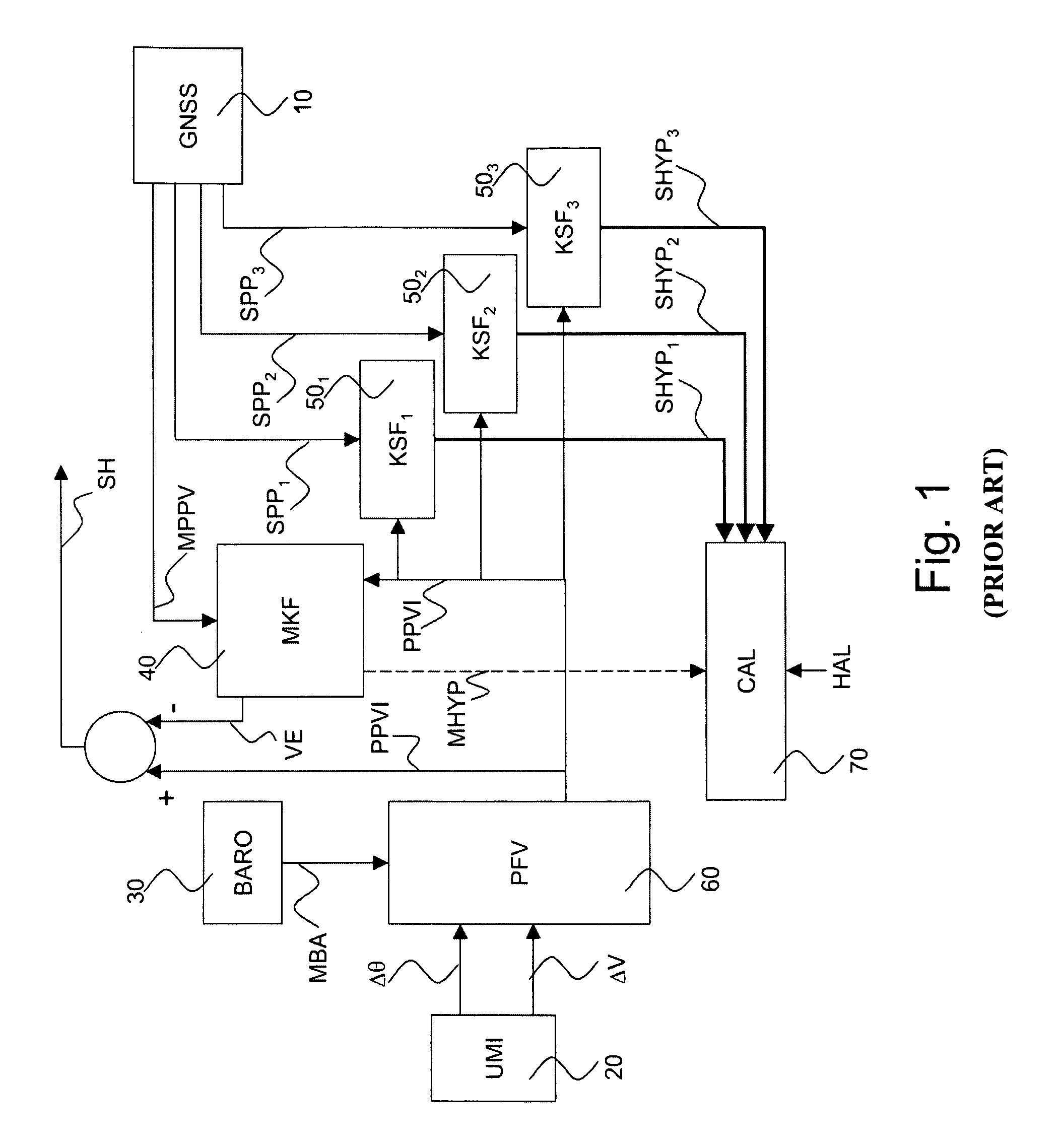
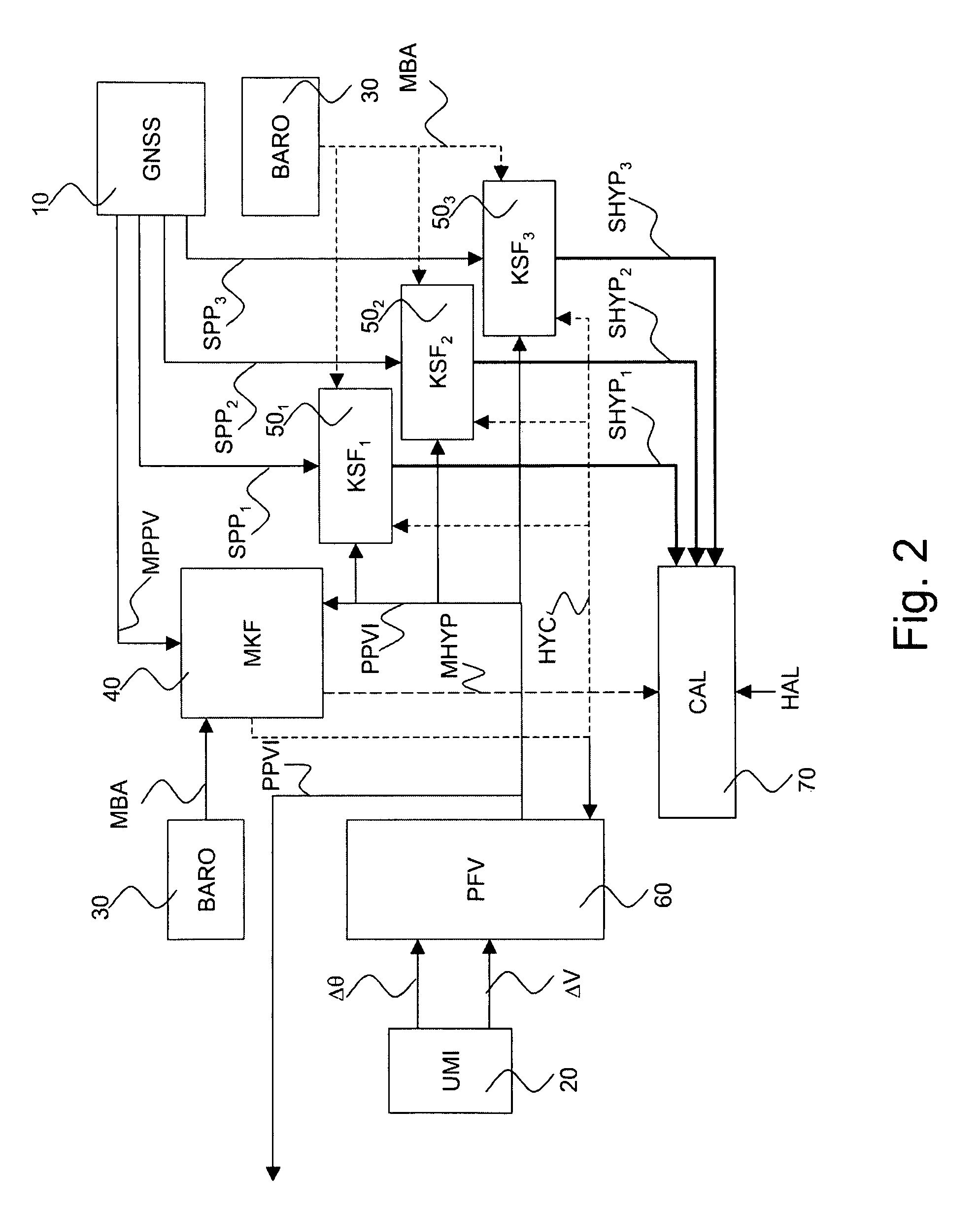
[0029]FIG. 1 represents a hybrid system according to the prior art. The hybrid system, comprises;[0030]a satellite-based positioning receiver, GNSS, 10, receiving signals from a constellation of N tracked visible satellites;[0031]an inertial measurement unit UMI, 20 delivering angle increments Δθ and speed increments ΔV;[0032]a barometric module BARO, 30, delivering measurements of barometric altitude MBA;[0033]a Kalman hybridization filter, MKF 40;

[0034]a bank of N secondary filters, KSFi 50i,

[0035]a virtual platform, PFV, 60 receiving the angle increments Δθ and the speed increments ΔV;[0036]a calculation module CAL, 70.

[0037]The inertial measurement unit, UMI comprises gyrometers and accelerometers (not represented): the angle increments Δθ are delivered by the gyrometers and the speed increments ΔV are delivered by the accelerometers.

[0038]The virtual platform, PFV receives the measurements of baromet...


PUM


Abstract

The invention pertains to the monitoring of the integrity of position and speed information arising from a hybridization between an inertial reference system and a satellite-based positioning receiver. The invention relates more precisely to a navigation apparatus known in the art by the name INS / GNSS system (for “Inertial Navigation System” and “Global Navigation Satellite System”) hybridized in closed loop.

Description

CROSS-REFERENCE TO RELATED APPLICATIONS[0001]The present Application is based on International Application No. PCT / EP2007 / 060139, filed on Sep. 25, 2007, which in turn corresponds to French Application No. 0608792 filed on Oct. 6, 2006, and priority is hereby claimed under 35 USC §119 based on these applications. Each of these applications are hereby incorporated by reference in their entirety into the present application.FIELD OF THE INVENTION[0002]The invention relates to the monitoring of the integrity of position and speed information arising from a hybridization between an inertial reference system and a satellite-based positioning receiver. The invention relates more precisely to a navigation apparatus known in the art by the name INS / GNSS system (for “Inertial Navigation System” and “Global Navigation Satellite System”) hybridized in closed loop.BACKGROUND OF THE INVENTION[0003]An inertial reference system includes a set of inertial sensors (gyrometric sensors and acceleromet...

Claims


Application Information

Patent Timeline
Patent Type & Authority Patents(United States)
IPC IPC(8): H04B7/19G01S5/14G01S19/20G01S19/47
CPCG01C21/165G01S19/47G01S19/20
Inventor COATANTIEC, JACQUESMARTIN, NICOLAS
Owner THALES SA
Why Eureka
Try Eureka