Combined electromagnetic and seismic acquisition system and method

a combined electromagnetic and seismic technology, applied in the field of geological surveying of the earths subsurface, can solve the problems of marine electromagnetic sensors that must be operated at water depths considered unsuitable for seismic acquisition, and can be particularly expensiv

Active Publication Date: 2012-01-17
PGS GEOPHYSICAL AS
View PDF24 Cites 37 Cited by
  • Summary
  • Abstract
  • Description
  • Claims
  • Application Information

AI Technical Summary

Problems solved by technology

Marine surveying can be particularly expensive because of the cost of operating the vessel used to tow the cables in the water.
It is believed to be impracticable, however, to combine seismic sensing devices and electromagnetic sensing devices in a single sensor cable or streamer because seismic streamers must generally be operated at shallow water depth to reduce the effects on seismic signals from the subsurface of seismic energy reflecting from the water surface.
Conversely, marine electromagnetic sensors must typically be operated at water depths believed to be unsuitable for seismic acquisition in order to reduce the effects of electromagnetic energy reflected from the water surface on electromagnetic signals from the subsurface.

Method used


Image

  • Combined electromagnetic and seismic acquisition system and method
  • Combined electromagnetic and seismic acquisition system and method
  • Combined electromagnetic and seismic acquisition system and method

Examples


Embodiment Construction

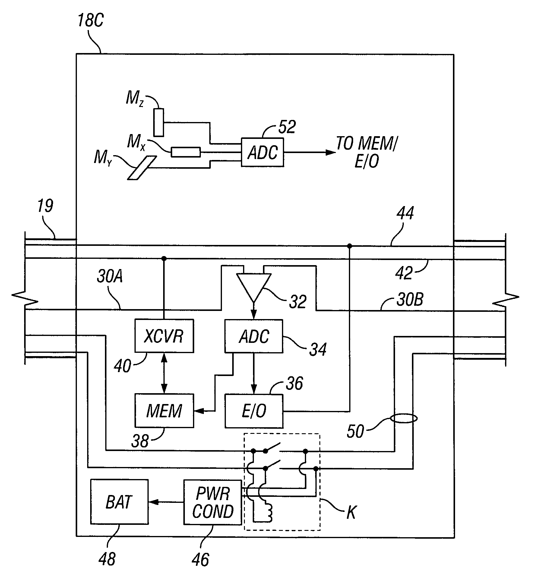
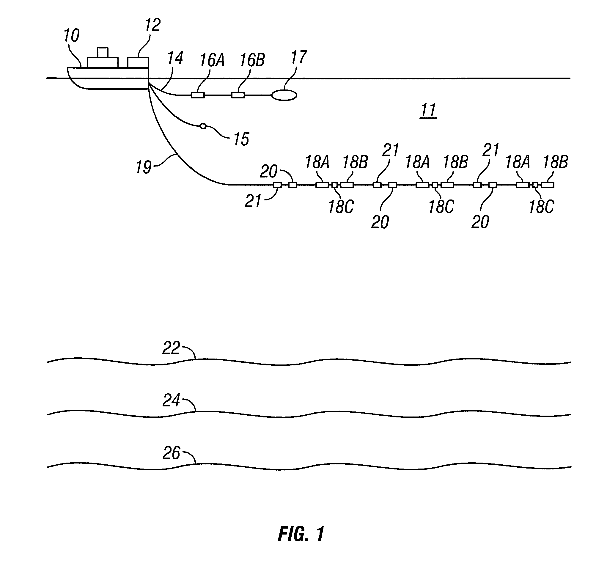
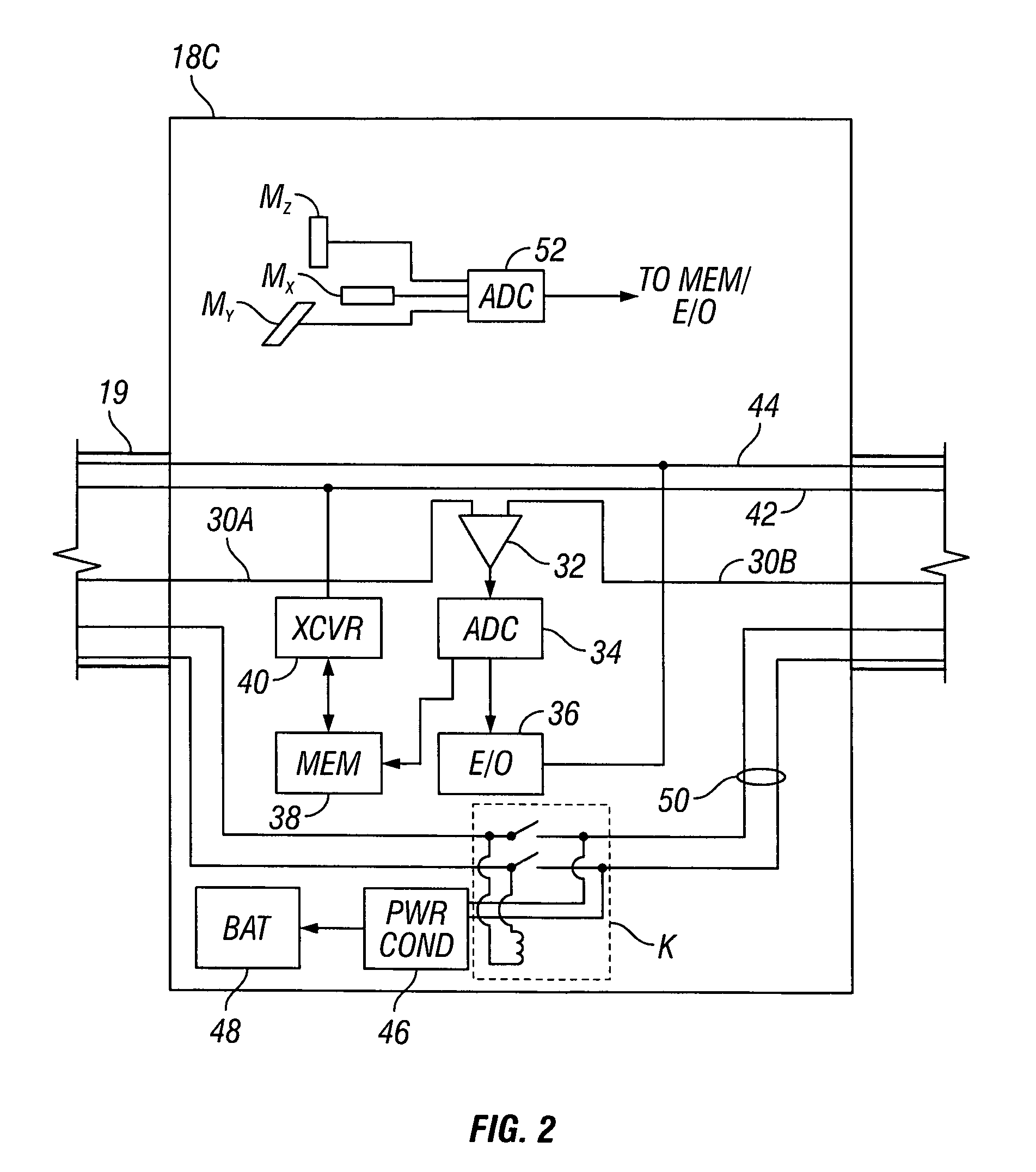
[0015]An example of a geophysical survey system that can perform contemporaneous marine electromagnetic surveying and marine seismic surveying is shown schematically in FIG. 1. The survey system includes a survey vessel 10 that moves along the surface of a body of water 11 such as a lake or the ocean. The survey vessel 10 typically includes thereon a geophysical survey recording system 12. The recording system 12 may include equipment (not shown separately for clarity of the illustration) for conducting both seismic and electromagnetic surveys, such as navigation devices to determine the geodetic position at any time of the survey vessel 10 and sensing instruments (explained below) deployed on one or more streamers in the water 11. The recording system equipment may also include power supplies and controls for actuating an electromagnetic field generator (explained below) and a seismic energy source (also explained below). The recording system equipment may also include devices for ...


PUM


Abstract

A method for marine geophysical surveying according to one aspect of the invention includes towing at least one geophysical sensor streamer in a body of water. The streamer includes a plurality of spaced apart electromagnetic field receivers disposed at spaced apart locations along the streamer. The streamer also includes a plurality of seismic sensors disposed at spaced apart locations. The seismic sensors each include at least one pressure responsive receiver and at least one particle motion responsive receiver. At selected times, a seismic energy source is actuated in the water. Particle motion and pressure seismic signals, and electromagnetic field signals are detected at the respective receivers.

Description

CROSS-REFERENCE TO RELATED APPLICATIONS[0001]Not applicable.STATEMENT REGARDING FEDERALLY SPONSORED RESEARCH OR DEVELOPMENT[0002]Not applicable.BACKGROUND OF THE INVENTION[0003]1. Field of the Invention[0004]The invention relates generally to the field of geophysical surveying of the Earth's subsurface. More specifically, the invention relates to systems and methods for combined electromagnetic and seismic surveying of the Earth's subsurface.[0005]2. Background Art[0006]Techniques for geophysical surveying of the Earth's subsurface include seismic surveying and electromagnetic surveying. Seismic surveying includes deploying a seismic energy source at or near the Earth's surface above an area that is to be surveyed, and deploying one or more arrays of seismic sensors at or near the surface in the vicinity of the seismic energy source. The source is actuated at selected times and signals detected by the seismic sensors are recorded. Electromagnetic surveying includes deploying a plura...

Claims


Application Information

Patent Timeline
Patent Type & Authority Patents(United States)
IPC IPC(8): G01V1/38
CPCG01V1/38G01V3/083G01V3/12Y02A90/30
Inventor HILLESUND, OYVINDLUNDE, NILS
Owner PGS GEOPHYSICAL AS
Why Eureka
Try Eureka