Automatic asset detection for disaster relief using satellite imagery

a technology of automatic asset detection and satellite imagery, applied in scene recognition, instruments, computing, etc., can solve the problems of pilots often not having enough time to look for water sources, helicopters may not have enough altitude to be able to see, etc., and achieve the effect of removing false positive indications

Inactive Publication Date: 2014-05-20
THE UNITED STATES OF AMERICA AS REPRESENTED BY THE SECRETARY OF THE NAVY
View PDF1 Cites 4 Cited by
  • Summary
  • Abstract
  • Description
  • Claims
  • Application Information

AI Technical Summary

Benefits of technology

[0009]The methods according to several embodiments can further include the step of building a reference spectral profile that can be based on the SOI. The reference spectral profile can extend into the near infrared wavelength range, in order to eliminate false positive indications. A satellite image of the spatial region of interest (ROI) can be taken. For each pixel in the ROI, test spectra of the spatial ROI can be extracted and compared to reference spectral profile using a spectral angle mapper (SAM) tool. When the comparison using the SAM tool falls below a certain value, that pixel of the ROI can be deemed to be indicative of a disaster relief asset. In cases where the pixel is indicative of a disaster relief asset, the geo-reference data for that pixel can be transmitted to a remote user (or simultaneously to a plurality of remote users) for the user's consideration.

Problems solved by technology

But the helicopter may not have enough altitude to be able to see all bodies of water that are within range for firefighting efforts.
The pilot often will not have enough time to look for water sources.

Method used


Image

  • Automatic asset detection for disaster relief using satellite imagery
  • Automatic asset detection for disaster relief using satellite imagery
  • Automatic asset detection for disaster relief using satellite imagery

Examples


Embodiment Construction

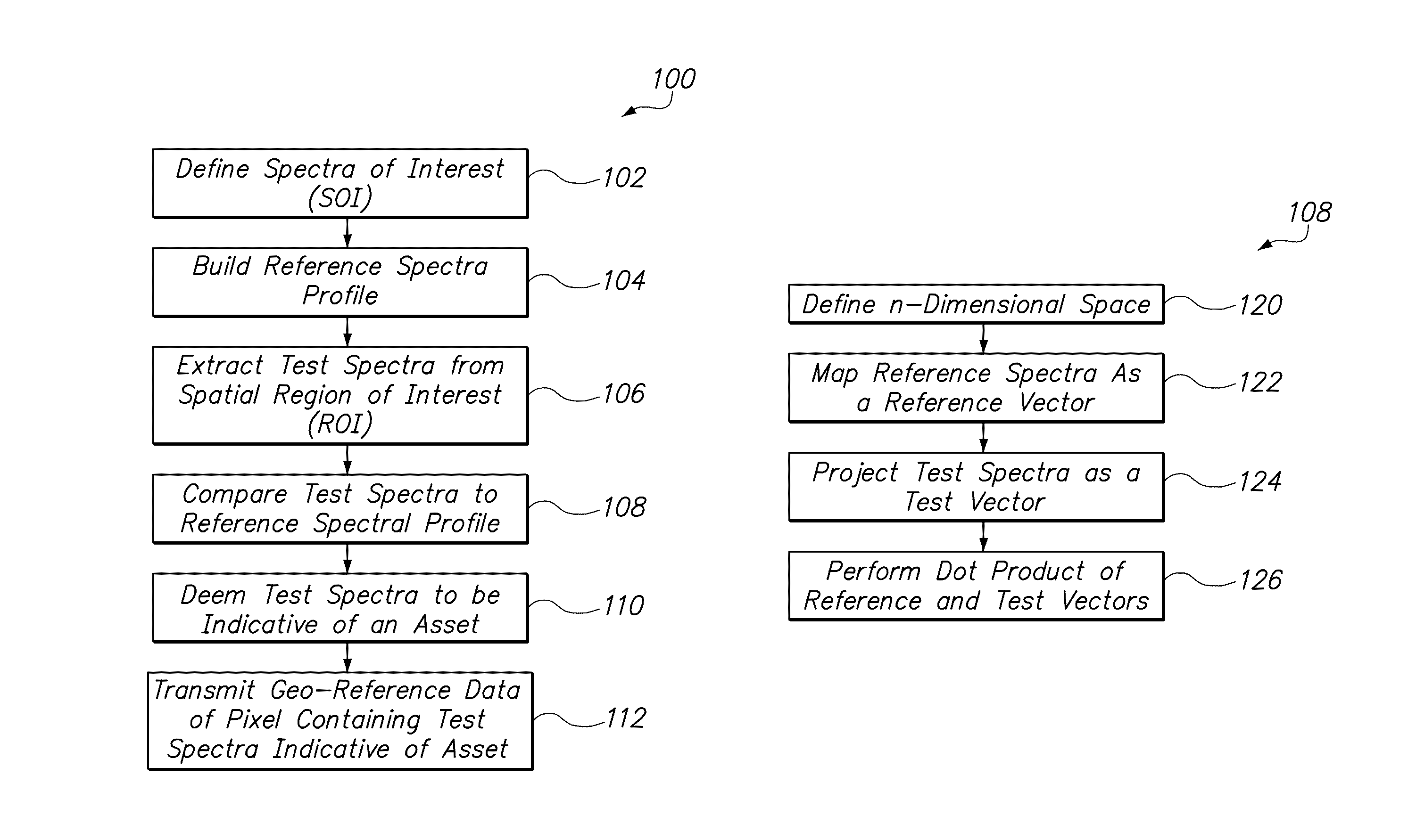
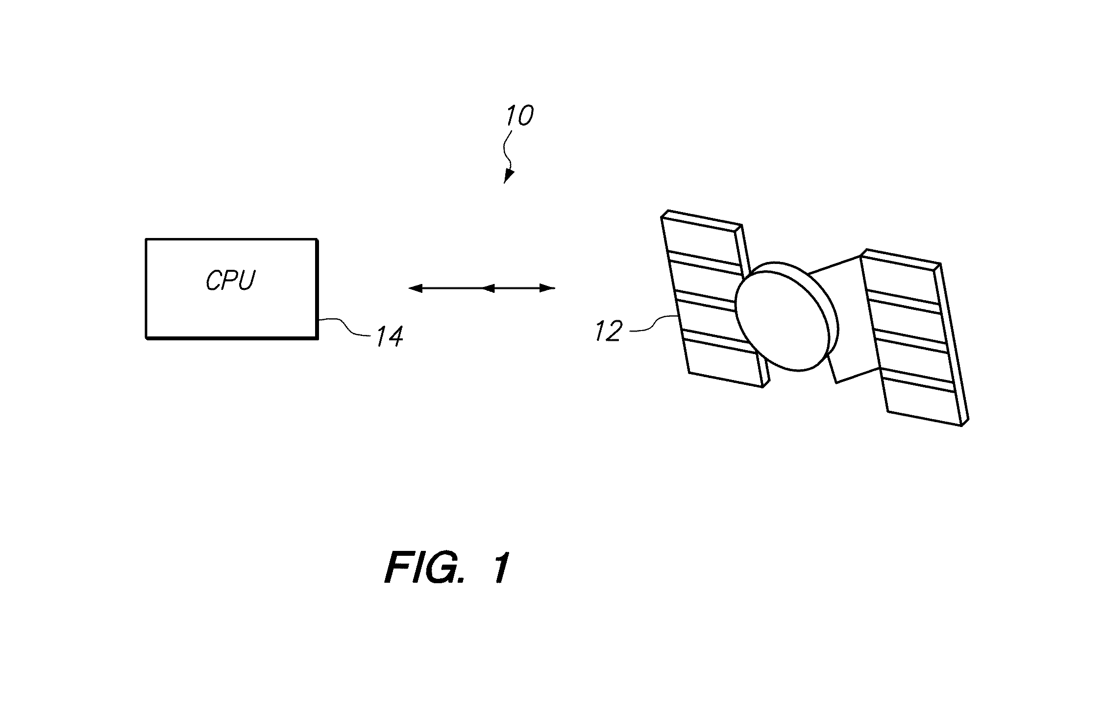
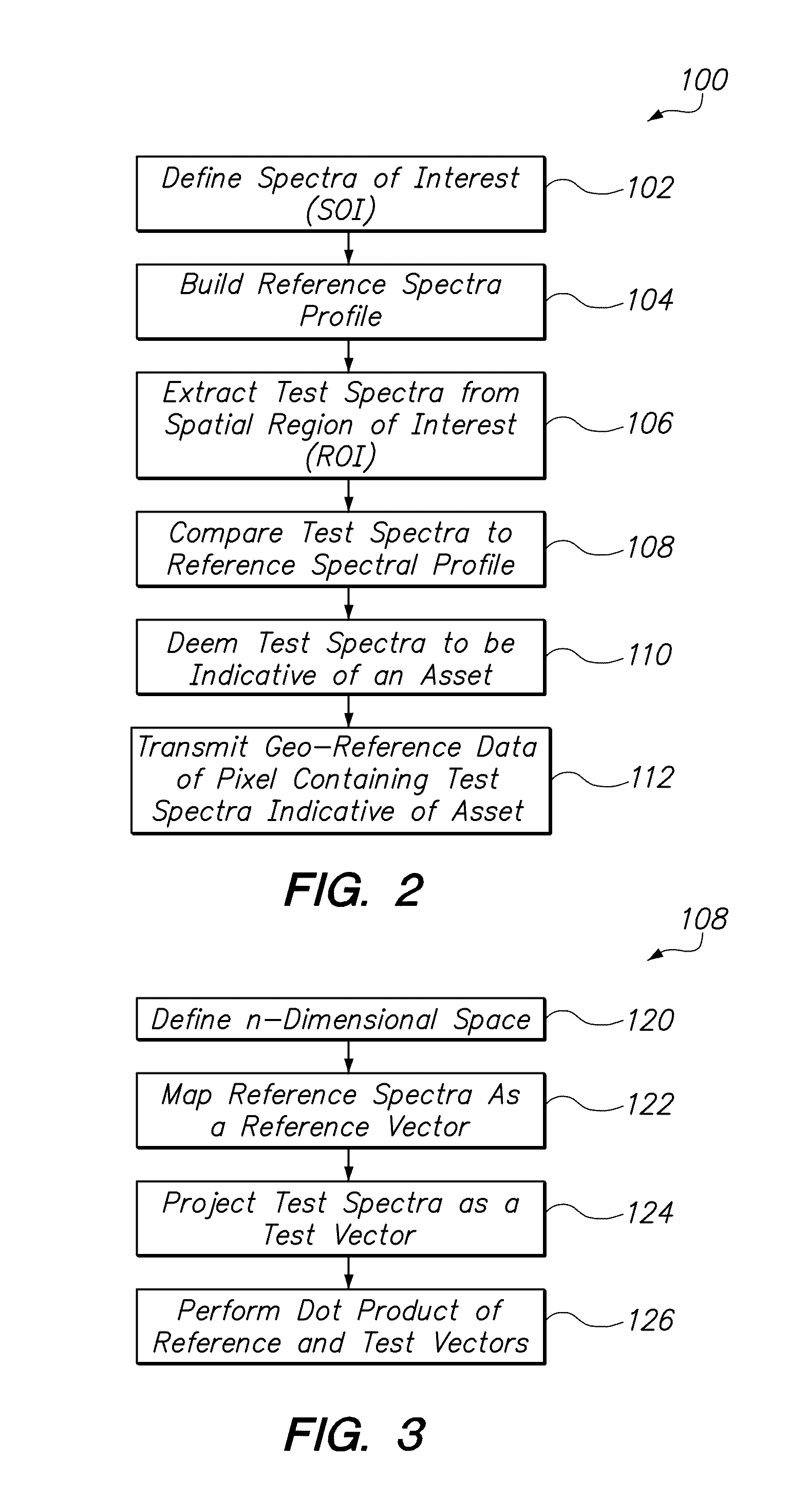
[0023]In brief overview, and referring initially to FIG. 1, a system for detecting disaster relief assets using satellite imagery is shown and is generally designated by reference character 10. As shown, the system 10 can include a satellite 12 and a processor 14 that is in communication with the satellite 12. The satellite can generate images of spatial regions of interest (ROI) using imagery methods that are known in the art. One such imagery method can include nadir panchromatic electro-optical imagery, although other methods for generating satellite imagery could also be used. It should also be appreciated that other sources of overhead imagery could be used to practice the methods of the present invention. For example, an aircraft (not shown) could be used to provide the applicable imagery. For these embodiments, the processor 14 could be located on the aircraft. The processor 14 can include non-transitory instructions such as computer programs, which when activated, can carry ...


PUM


Abstract

Systems and methods for automatic detection of disaster relief assets from a satellite image can include a satellite and a processor, which can contain non-transitory written directions that perform a method, which includes the step of defining spectra of interest (SOI). A reference spectral profile that is based on the SOI is built. The reference spectral profile can extend into the near infrared range to eliminate false positive indications. A satellite image of the spatial region of interest (ROI) is taken. For each pixel in the ROI, test spectra of the spatial region can be extracted and compared to the reference spectral profile using a spectral angle mapper (SAM) tool. When the comparison meets predetermined parameters, that pixel of the ROI can be deemed to be indicative of a disaster relief asset, and the geo-reference data for that pixel can be transmitted to a remote user.

Description

[0001]This application is a continuation-in-part of prior application Ser. No. 12 / 777,349, filed May 11, 2010 now U.S. Pat. No. 8,369,567.FEDERALLY-SPONSORED RESEARCH AND DEVELOPMENT[0002]This invention (Navy Case No. 101577) is assigned to the United States Government and is available for licensing for commercial purposes. Licensing and technical inquires may be directed to the Office of Research and Technical Applications, Space and Naval Warfare Systems Center, Pacific, Code 72120, San Diego, Calif. 92152; voice (619) 553-5118; email ssc pac T2@navy.mil.FIELD OF THE INVENTION[0003]The present invention applies generally to satellite imagery. More specifically, some embodiments of the invention pertain to the processing of satellite vessel imagery to quickly and automatically detect assets for disaster relief, such as sources of water for firefighting efforts, according to a predetermined algorithm.BACKGROUND OF THE INVENTION[0004]Aerial firefighter pilots often use helicopters wi...

Claims


Application Information

Patent Timeline
Patent Type & Authority Patents(United States)
IPC IPC(8): G06K9/68G06K9/00G06V20/13
CPCG06K9/0063G06K2009/00644G06V20/194G06V20/13
Inventor FITZSIMMONS, BOBUCK, HEIDIBAGNALL, BRYANSHARGHI, ELAN
Owner THE UNITED STATES OF AMERICA AS REPRESENTED BY THE SECRETARY OF THE NAVY
Why Eureka
Try Eureka