Method of determining a heading in the geographical north direction by means of an inertial unit

a technology of inertial unit and geographical north direction, applied in the direction of navigation instruments, navigation by terrestrial means, instruments, etc., can solve the problems of falsifying north seeking, affecting the accuracy of navigation, and increasing the price of accelerometers, so as to reduce the standard deviation of error, limit the heading error, and save acceptable statistical accuracy

Active Publication Date: 2014-06-10
SAFRAN ELECTRONICS & DEFENSE
View PDF14 Cites 2 Cited by
  • Summary
  • Abstract
  • Description
  • Claims
  • Application Information

AI Technical Summary

Benefits of technology

[0012]Thus, the first heading value is calculated by using the inertial sensor module as a North seeker, i.e. by calculating the heading from gyro data, data from the accelerometers not being used when calculating the heading itself, but being used merely to determine the mean horizontal plane relative to the sensor module. The second heading value is calculated using gyro-compass mode, i.e. calculating the heading from accelerometer data, with gyro data being used only for stabilizing the platform. This makes it possible to obtain a heading value that is relatively accurate by limiting any risk of large error associated with angular movement of the inertial unit.
[0016]These two heading values are affected by errors including a common component that results from the mean drift of the gyros during measurement, and a non-common component that results from variations in accelerometer bias (or offset). The effect of accelerometer bias drift is negligible for the first heading value, but can generate a heading error that is greater than the effect of gyro errors for the second heading value. In contrast, the difference between the two heading values is not affected by gyro drift, which is thus eliminated on calculating the difference. The difference can then be used as a discriminating value for retaining one heading value or the other as the heading value in the North direction in a manner that is simple and reliable. If the difference is very small or zero, then the first heading value, which in absolute terms is the more accurate, is the value that is retained. Otherwise, it is the second heading value that is retained. The method of the invention thus makes it easier to select the method of operation that provides the best performance as a function of measurement conditions.
[0025]adding together the first and second heading values as weighted in this way to obtain the heading in the North direction, the weighting being determined so as to minimize a standard deviation of error concerning the heading in the North direction.
[0026]This makes it possible to limit heading error in the event of movement, while conserving acceptable statistical accuracy in the absence of angular movement of the sensor module relative to the ground, without having recourse to expensive accelerometers.

Problems solved by technology

In contrast, the smallest amount of movement of the gyro, even when not perceptible for a human being, rapidly degrades this accuracy and falsifies North seeking.
Nevertheless, the accuracy of the heading as determined in this way depends on the accuracy of the accelerometers, and accelerometer price increases rapidly as a function of the required accuracy.

Method used


Image

  • Method of determining a heading in the geographical north direction by means of an inertial unit
  • Method of determining a heading in the geographical north direction by means of an inertial unit

Examples


Embodiment Construction

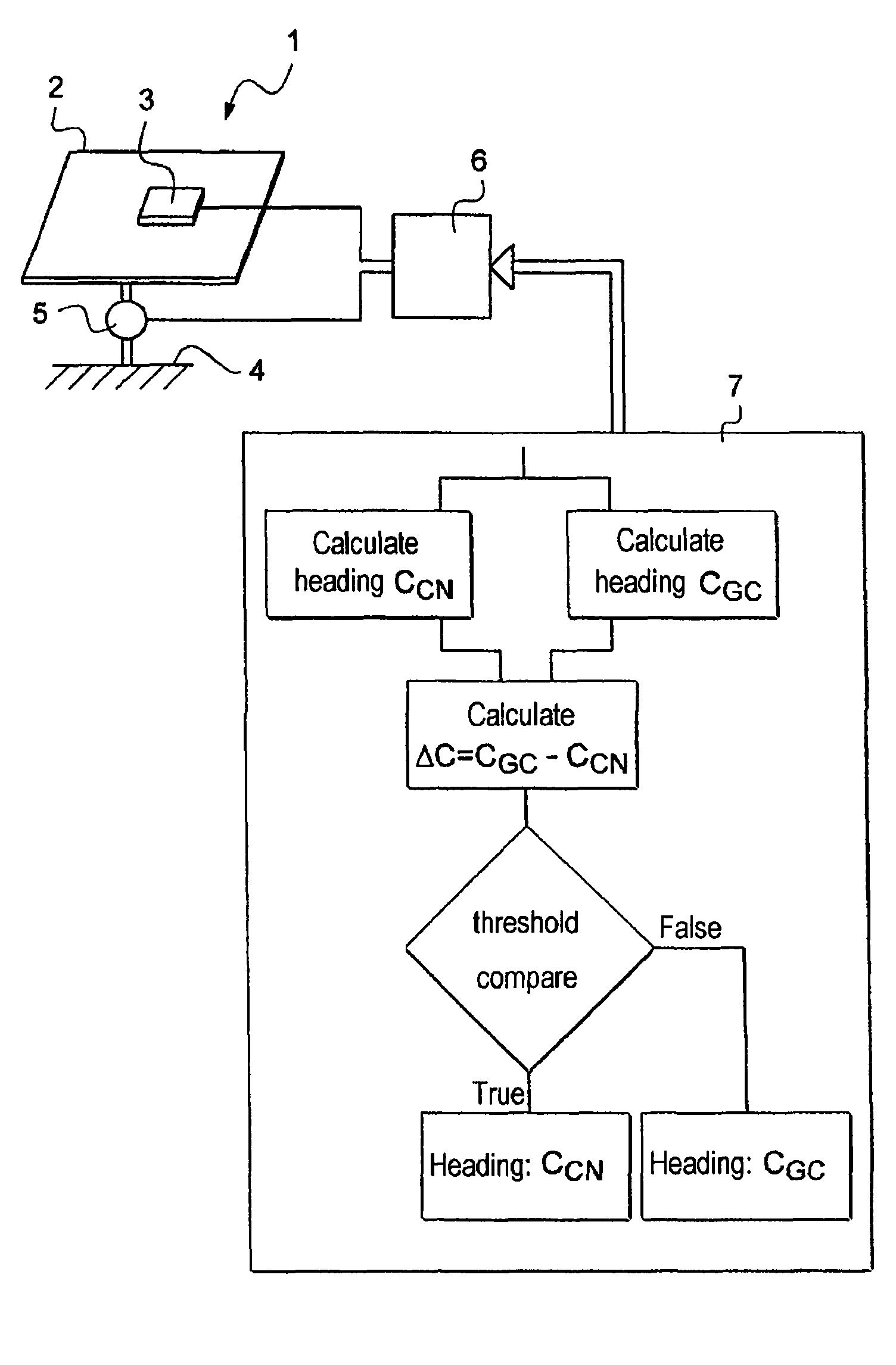
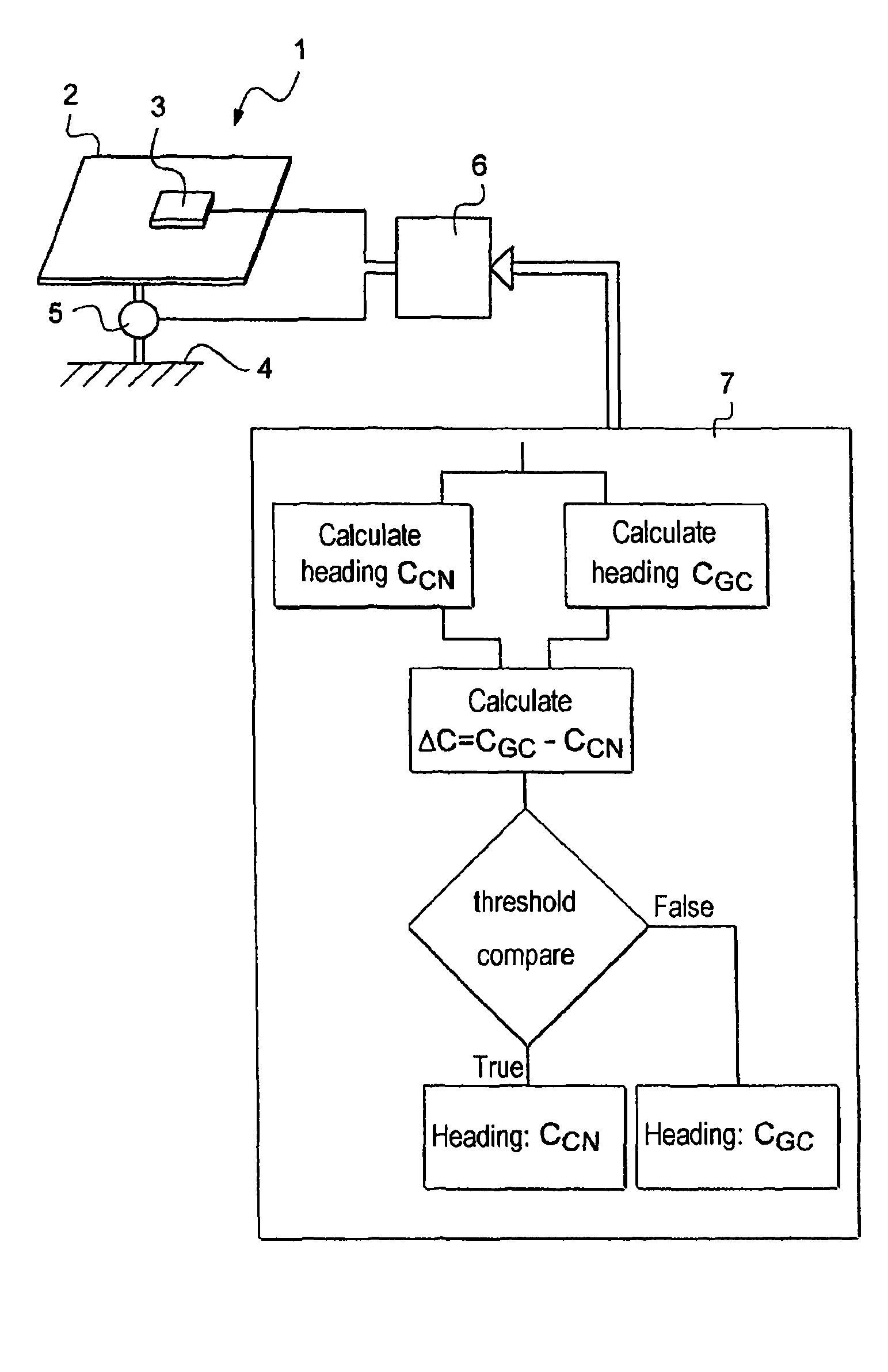
[0031]The method of the invention relates to seeking geographical North by means of an inertial sensor module or inertial unit 1 that includes a platform 2 fitted with accelerometers 3 (only one of which is shown in the FIGURE) and that is connected by rate gyros 5 (only one of which is shown in the FIGURE) to a stationary support 4 such as a housing. It should be understood that the description and the representation of the inertial unit are simplified to the extreme, since the invention does not relate to the structure of the inertial unit, which structure is known from elsewhere. The inertial unit 1 is secured to a piece of equipment, such as a vehicle, having a structure to which the housing of the inertial unit 1 is rigidly secured.

[0032]The inertial unit 1 is associated with a computer 6 that executes a program 7 for controlling the inertial unit 1 for the purpose of calculating a heading towards geographical North:[0033]as a North seeker by using the data signals delivered by...


PUM


Abstract

A method of determining a heading in the geographical North direction by means of an inertial sensor module having three rate gyro measurement axes and three accelerometer measurement axes, the method comprising the steps of:using data from the inertial sensor module in a North-seeking mode to obtain a first heading value;using data from the inertial sensor module in a gyro-compass mode to obtain a second heading value; anddetermining the heading in the North direction by using the first heading value and the second heading value.

Description

FIELD OF THE INVENTION[0001]The present invention relates to a method of seeking a heading in the geographical North direction.BACKGROUND OF THE INVENTION[0002]Seeking geographical North is a stage prior to any operation concerning aiming, plotting or spotting, guidance, or navigation, in order to determine a reference heading from which aiming or navigation data is to be determined. When guidance and navigation are performed by means of a system including an inertial unit or an inertial sensor module, the system becomes operational once it has been “aligned” on this heading.[0003]It is known to determine a heading in the North direction by using a North seeker that comprises a free gyro firmly secured to the ground in a horizontal position. The North seeker determines accurately the North direction in the absence of the gyro moving relative to the surface of the Earth. The accuracy of the determination depends mainly only on the drift of the gyro, or the stability of the drift when...

Claims


Application Information

Patent Timeline
Patent Type & Authority Patents(United States)
IPC IPC(8): G01C21/08
CPCG01C21/16G01C19/38G01C25/005G01C21/166
Inventor BECHERET, YVES
Owner SAFRAN ELECTRONICS & DEFENSE
Why Eureka
Try Eureka