Vision system and method of analyzing an image

a vision system and image technology, applied in the field of vision systems, can solve the problems of reducing affecting the accuracy of object recognition, so as to achieve the effect of enhancing the robustness and speed of object recognition

Active Publication Date: 2015-01-06
HARMAN BECKER AUTOMOTIVE SYST
View PDF27 Cites 32 Cited by
  • Summary
  • Abstract
  • Description
  • Claims
  • Application Information

AI Technical Summary

Benefits of technology

[0009]The vision system utilizes the annotated map data, which may include geo-referenced feature descriptors. By matching feature descriptors determined for the image and the geo-referenced feature descriptors of the annotated map data, information stored in the annotated map data may be utilized to identify objects for which an associated geo-referenced feature descriptor is included in the annotated map data. Recognition of the object may, on average, be performed faster and more robustly than in cases where no a-priori information is used, and / or the results of the matching may be utilized to determine a position more accurately. Utilizing feature descriptors provides robustness against a variety of different environmental conditions, such as different lighting conditions.
[0020]The positioning device may be configured to determine an orientation of the vision system, which may be defined to be the orientation of the optical axis of the camera. For a vision system installed in a vehicle, the positioning device may determine the vehicle orientation. The processor may be configured to estimate the location of the object in the image further based on the orientation of the vision system. This allows the location of the object to be estimated with even higher precision. The accuracy and / or speed of object recognition may, on average, be enhanced.
[0021]The processor may be configured to identify a portion of the at least one image based on the vision system position and based on position information associated with at least one of the plurality of retrieved geo-referenced feature descriptors. The processor may be configured to selectively determine the at least one feature descriptor for the identified portion of the image. The processing speed may, on average, be enhanced by limiting the processing performed by the processor to the portion of the image, which is smaller in size than the image. The processor may be configured to determine a feature vector for the portion of the image.
[0023]The vision system may include an optical output device. The processor may be configured to control the optical output device to output information indicating an object in the at least one image which has a feature descriptor matching one of the retrieved geo-referenced feature descriptors. This allows information to be specifically assigned to objects in the user's field of view.
[0024]At least one of the geo-referenced feature descriptors may have associated position information that includes height information. The processor may be configured to perform the matching procedure based on the height information. By utilizing height information, possibly in addition to information on lateral coordinates associated with a geo-referenced feature descriptor, it is possible to identify all three parameters specifying the vehicle orientation in space (e.g., Euler angles) using the matching procedure. If the position and / or vehicle orientation are determined independently of the image, the robustness and speed of object recognition may be enhanced.
[0030]The method utilizes the annotated map data that includes geo-referenced feature descriptors. By matching feature descriptors determined for the image and the geo-referenced feature descriptors of the annotated map data, information stored in the annotated map data may be utilized to identify objects for which an associated geo-referenced feature descriptor is included in the annotated map data. Recognition of the object may, on average, be performed faster and more robustly than in cases where no a-priori information is used, and / or the results of the matching may be utilized to determine a position more accurately. Utilizing feature descriptors provides robustness against a variety of different environmental conditions, such as different lighting conditions.

Problems solved by technology

There are various difficulties associated with automatically performing object recognition.
However, this represents a considerable challenge.
While techniques applied to prior art vehicle vision systems may be useful to reliably classify objects into one of a limited number of classes, such as for detecting traffic signs, road markings or other vehicles, such applications do generally not allow specific POIs to be reliably identified.
However, techniques such as the ones described above may not be suitable to identify such landmarks unless, for example, a neural network has specifically been trained for them.

Method used


Image

  • Vision system and method of analyzing an image
  • Vision system and method of analyzing an image
  • Vision system and method of analyzing an image

Examples


Embodiment Construction

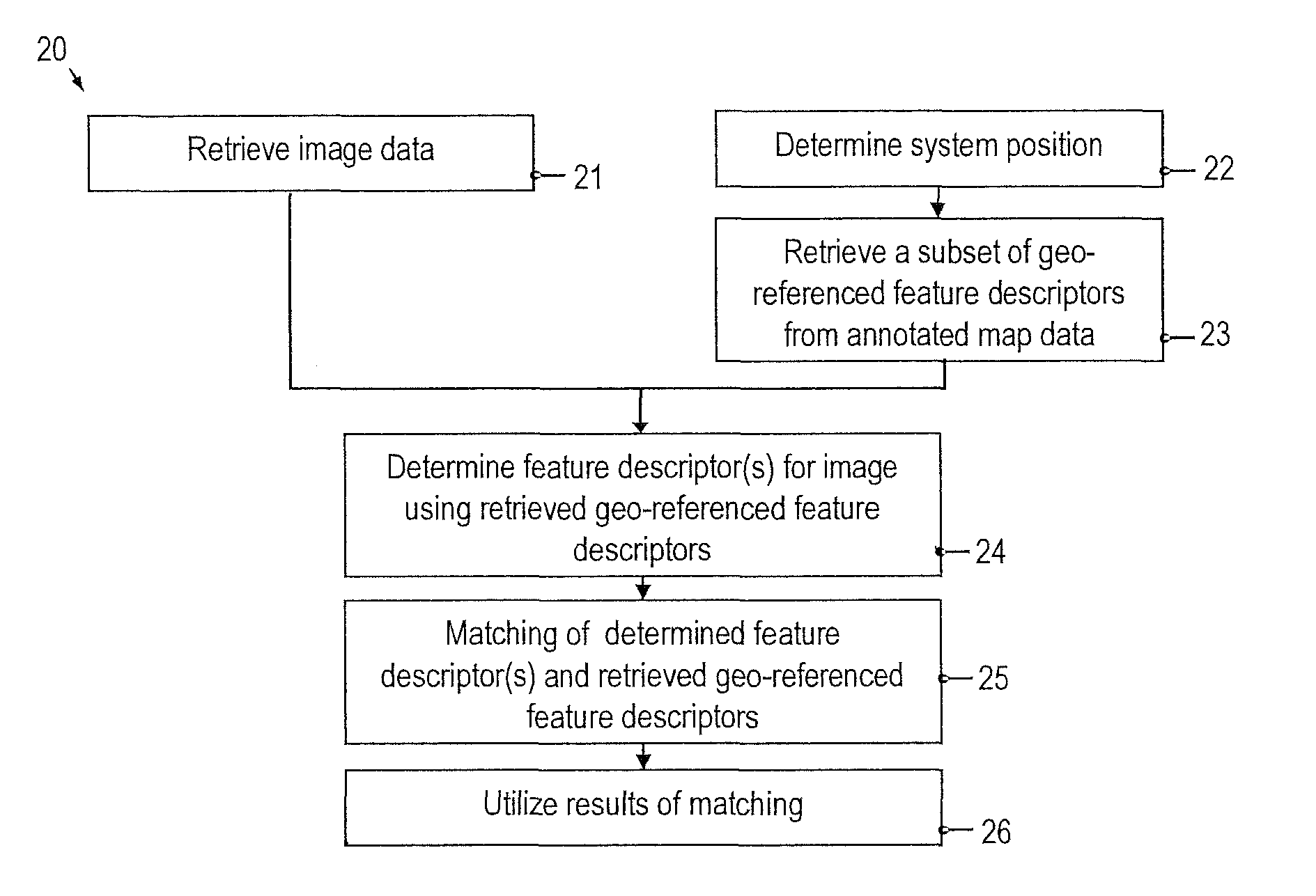
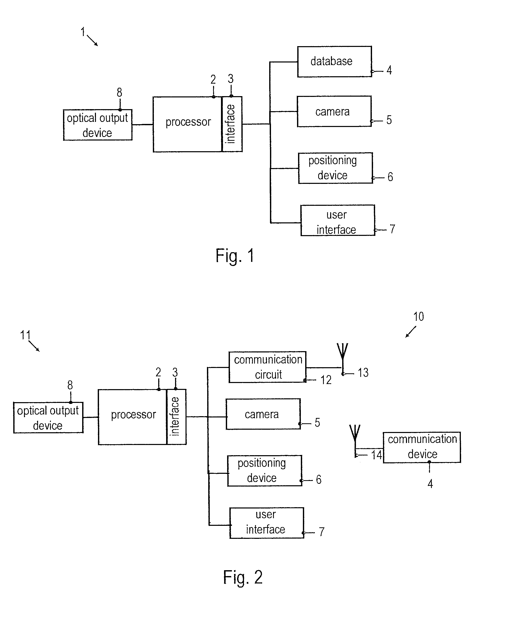
[0057]Embodiments of the invention will be described with reference to the drawings. While some embodiments will be described in the context of vehicle vision systems, the systems and devices of various embodiments may be employed in a wide variety of applications. The features of embodiments may be combined with each other unless specifically stated otherwise.

[0058]According to embodiments, geo-referenced feature descriptors, which may be combined to form geo-referenced feature vectors, are utilized for object recognition in an automated vision system. As used herein, the term “geo-referenced” refers to a quantity that is associated with at least a pair of coordinates specifying the lateral position of an object associated with the quantity. For example, a geo-referenced feature descriptor is a feature descriptor that is associated with at least a 2-tuple of coordinates, which represent a position or position estimate of the object represented by the geo-referenced feature descript...


PUM


Abstract

A vision system comprises a camera that captures an image and a processor coupled to process the received image to determine at least one feature descriptor for the image. The processor includes an interface to access annotated map data that includes geo-referenced feature descriptors. The processor is configured to perform a matching procedure between the at least one feature descriptor determined for the at least one image and the retrieved geo-referenced feature descriptors.

Description

CLAIM OF PRIORITY[0001]This patent application claims priority from EP Application No. 10 014 418.7 filed Nov. 9, 2010, which is hereby incorporated by reference.FIELD OF TECHNOLOGY[0002]The invention relates to a vision system, and in particular to an automated vehicle vision system.RELATED ART[0003]Machine vision is practiced in a wide variety of systems. Recently, applications that employ vision systems in automotive environments have been contemplated for safety or other applications. In particular, image recognition in automotive systems may be employed for various purposes including navigation or aiding the driver in controlling a vehicle. For these purposes, images of a neighborhood of the vehicle are recorded, frequently by a camera onboard a vehicle, and analyzed in order to identify objects (e.g., roads or road edges), that may be of relevance for navigation purposes or for controlling the vehicle. Once an object has been identified or recognized in an image, specific proc...

Claims


Application Information

Patent Timeline
Patent Type & Authority Patents(United States)
IPC IPC(8): G06K9/00G01C22/00G01C21/36
CPCG01C21/3602G06K9/00791G06K2209/27G06V20/56G06V2201/10
Inventor PLATONOV, JURIPRYAKHIN, ALEXEYKUNATH, PETER
Owner HARMAN BECKER AUTOMOTIVE SYST
Why Eureka
Try Eureka