
Systems and methods for providing optimized taxiing path operation for an aircraft

a taxiing path and optimization system technology, applied in the field of aircraft taxiing systems, can solve the problems of insufficient accuracy and data/time consumption of applications, large workloads of flight crews, slow and cumbersome manual process of entering sequences, etc., and achieve the effect of small memory space and easy embedding in different sequences

Active Publication Date: 2016-11-15
AIRBUS OPERATIONS (SAS)
View PDF6 Cites 10 Cited by
  • Summary
  • Abstract
  • Description
  • Claims
  • Application Information

AI Technical Summary

Benefits of technology

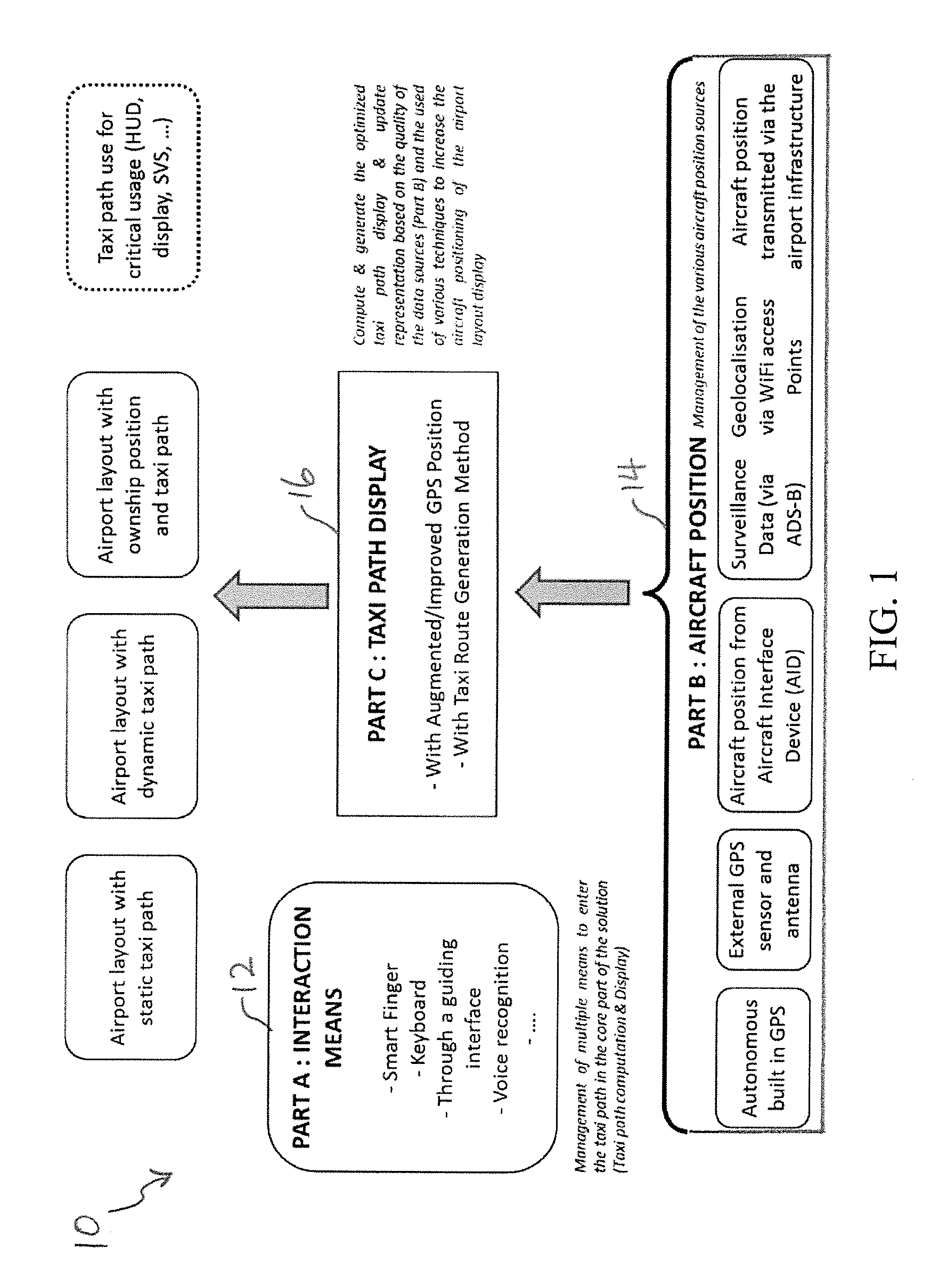
[0012]Advantages are achieved by the present taxiing path optimization system which includes an improved Airport Graph Database (AGDB) for storing specific information relating to geographic and geometric relationships between an aircraft and its surrounding objects in a two or three dimensional coordinate system. The present taxiing path optimization system further includes a computer processor coupled to databases and programmed to perform tasks and display positional information of airport elements and paths. Included in the present AGDB is a description of an airport flow graph, and is designed to take up minimal space in memory such that it can be readily embedded in different applications, such as avionics systems in an aircraft.
[0014]As discussed in greater detail below, the present taxing path optimization system provides an enhanced support function for taxiing operations with an optimized dynamic behavior of the taxi path update using various positioning sources and augmented algorithm techniques. In a preferred embodiment, it is contemplated that a system and method is provided for processing multiple sources of data for positioning of the aircraft using at least one of an internal or external GNSS sensor, a geometric layout data system, an Automatic dependent surveillance-broadcast (ADS-B), a wireless technology (e.g., Wifi), and the like.
[0015]Also included in the present taxiing path optimization system is that a system and method configured for correlating various sources of positioning data with the geometric topology of an airport layout. Further, the present taxing path optimization system provides enhanced displays and updates of the taxi path based on GNSS positions related to the airport elements and the aircraft in real time.
[0016]The present taxing path optimization system automatically generates the taxi route for the aircraft based on the positional information. As a result, a stable and efficient taxi route is maintained during taxiing, and a reliable on-ground navigation is provided while the aircraft is moving on a runway or taxiway, or when the aircraft is in a standby mode at a terminal gate or on the runway or taxiway. Thus, the present taxing path optimization system provides a reliable means of assisting in the operation of the aircraft during on-ground taxing or while being parked at the terminal gate or other locations at the airport.
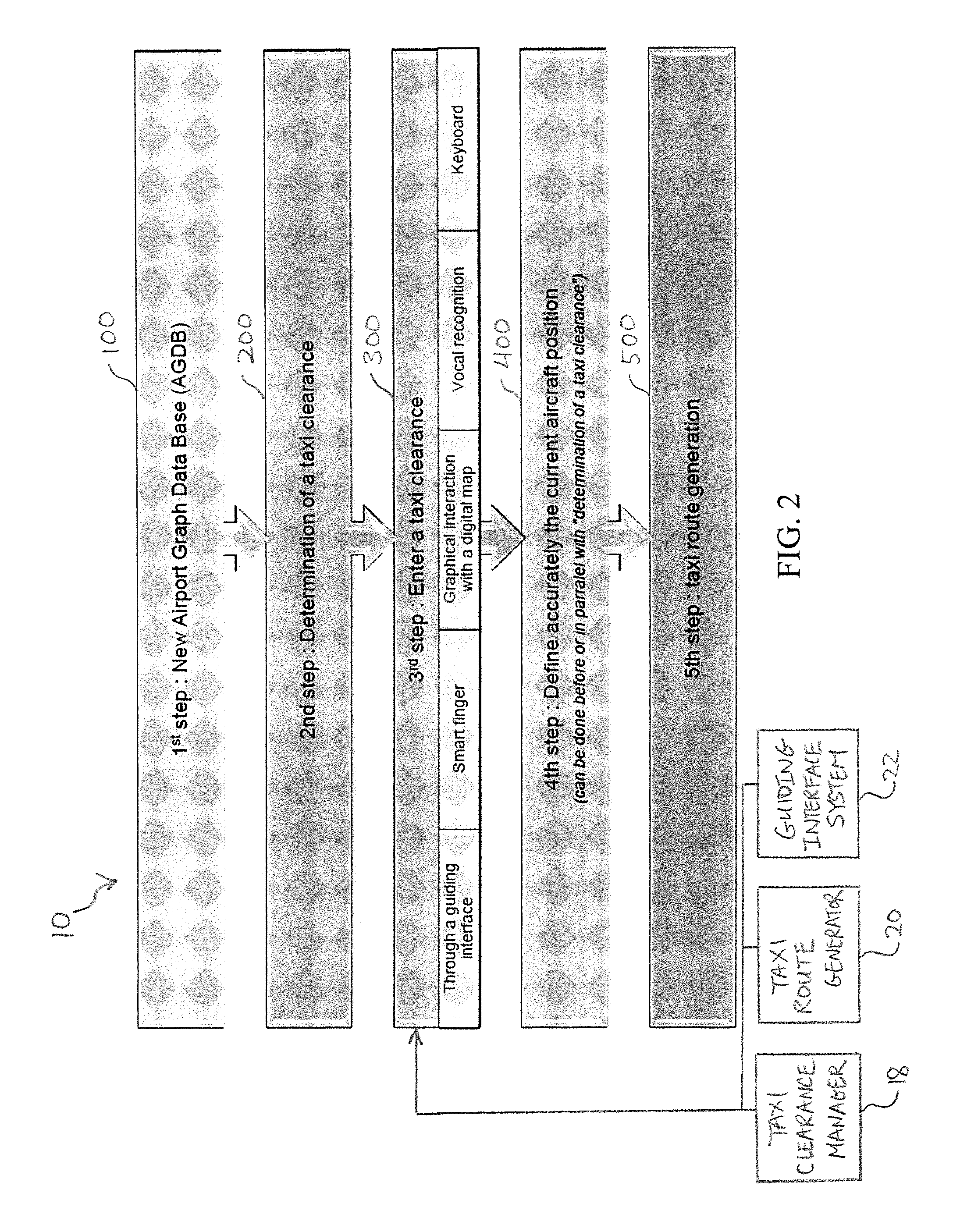
[0017]Other advantages of the present taxing path optimization system include, as described in greater detail below, a pre-computed connectivity of each link and a pre-computed dual relationship between points and nodes, curves and links, and links and airport elements. Because the present optimization system enables the flight crew member to quickly enter a taxi clearance during a taxi phase, the operation time, costs, and workload are reduced significantly. Since the taxi clearance input does not have to be complete or continuous, and the present optimization system automatically constructs the taxi clearance by filling in potential gaps, the crew can quickly select the taxi clearance by entering only a portion of the entire taxi clearance. For example, entering only the departure and destination elements suffices, and intermediate clearance elements between the departure and destination elements are automatically generated by the present optimization system. As a result, the next element entered in the taxi clearance does not need to be contiguous to the previous element because the present optimization system automatically fills in the elements between adjacent elements.
[0019]In another embodiment, a method of computing a taxi route for an aircraft is provided. The taxi route represents an on-ground trajectory of an airport during taxiing operations utilizing a taxiing path optimization system. Included in the method are building a display-independent and geometrically-based database for describing a flow graph of the airport, the database representing a description of all potential taxi ground trajectories for the aircraft; receiving an initial taxi clearance having airport elements, the taxi clearance being inputted by a user or a related system based on information stored in the database; modifying the initial taxi clearance by eliminating ambiguous taxi routes caused by the initial taxi clearance, and by resolving gaps between the airport elements in the initial taxi clearance; and finalizing the taxi route based on the modified taxi clearance for on-ground navigation of the aircraft at the airport.

Problems solved by technology

As a result, the workloads of the flight crews become significant and convoluted during airport surface operations.
Today, certain conventional applications are provided for an effective taxing operation, but these applications are not accurate enough and are data / time consuming.
This manual process of entering the sequence is slow and cumbersome because the clearance needs to be continuous (i.e., each clearance element must be connected to a successive one).
Thus, the flow graph of the airport includes unnecessary geometrical descriptions of the airport, causing memory space waste, longer computation time, and redundant complexity for generating the taxi route.
Further, because this type of flow graph does not include an explicit connectivity of each edge, the associated application must determine to which set of edges a given edge is connected, thereby causing additional computation time.
Typically, this type of flow graph only includes taxiways and runways, and does not have parking apron and deicing areas, making it impossible to compute the taxi route from or to a gate or a parking stand.
Another disadvantage of the conventional application is that when a system of visualization of the taxi clearance is available in the cockpit via the avionics system or an Electronic Flight Bag (EFB) system, the flight crews often must use a piece of paper to write down the clearance before entering the clearance into the system, and explicitly advise the avionics system that the pilot will manually enter the clearance.
However, the drawback of Component On-The-Shelf (COTS) tablets is that a GNSS position provided by the tablets does not satisfy mandated accuracy required in the aviation rules and regulations, such as a general acceptable means of compliance for airworthiness of products, parts and appliances, namely AMC 20-25.
All these steps take additional time and increase workload during the taxiing operation while the pilot simultaneously performs other tasks, such as checking and controlling the aircraft, communicating with ground personnel, performing surveillance tasks, and the like.
These additional tasks can be a source of potential errors, and may require significant time and effort to correct mistakes while listening to ATC instructions, thereby increasing operation costs.

Method used


Image

  • Systems and methods for providing optimized taxiing path operation for an aircraft
  • Systems and methods for providing optimized taxiing path operation for an aircraft
  • Systems and methods for providing optimized taxiing path operation for an aircraft

Examples


Embodiment Construction

[0038]Preferred embodiments of the present disclosure are described below by way of example only, with reference to the accompanying drawings. Further, the following description is merely exemplary in nature and is in no way intended to limit the disclosure, its application, or uses. As used herein, the term “module” or “unit” may refer to, be part of, or include an Application Specific Integrated Circuit (ASIC), an electronic circuit, a processor (shared, dedicated, or group) and / or memory (shared, dedicated, or group) that executes one or more software or firmware programs, a combinational logic circuit, and / or other suitable components that provide the described functionality. Thus, while this disclosure includes particular examples and arrangements of the modules, the scope of the present system should not be so limited since other modifications will become apparent to the skilled practitioner.

[0039]Referring now to FIG. 1, the present taxiing path optimization system is general...


PUM


Abstract

A taxiing path optimization system is provided for computing a taxi path of an aircraft using available taxi routes of a corresponding airport. An interaction means management unit manages interactions between a user and the taxiing path optimization system using an interactive device for inputting a taxi clearance. An aircraft positioning management unit manages positional information of the corresponding airport and aircraft received from a plurality of sources for augmenting an aircraft position by consolidating the aircraft position with the positional information in a complementary fashion. A taxi path display unit displays the taxi path based on the inputted taxi clearance and the augmented aircraft position, wherein the taxi path is automatically computed based on aircraft characteristics or airport capabilities.

Description

FIELD OF THE DISCLOSURE[0001]The present disclosure generally relates to aircraft taxiing systems, and in particular relates to a taxiing path optimization system for an aircraft using positioning data collected from various sources.BACKGROUND OF THE INVENTION[0002]To assist in navigation in an airport, a process of taxiing typically includes receiving a clearance from an air traffic controller (ATC), checking the received clearance, entering the received clearance into a navigation system for displaying the clearance on a map, and building a taxi route from a current position to a destination position, for example, on a runway or at a parking gate.[0003]In preparation for the taxiing, flight crews perform several tasks. The crews determine an accurate position of the aircraft by observing its external surroundings and / or a map. Then, the crews find and monitor a taxiing path based on the ATC clearance while monitoring an outside events and movements for preventing collision with ot...

Claims


Application Information

Patent Timeline
Patent Type & Authority Patents(United States)
IPC IPC(8): G01C21/36G08G5/06G01C21/28G08G5/00
CPCG08G5/065G01C21/28G01C21/3626G01C21/3667G08G5/0013G08G5/0021B64F1/002G01C21/20G01C21/3453
Inventor DEPAPE, PIERRESCACCHI, PIERRELOUISE, PASCALEBOUNAIX, FRANCOISSTANISLAWIAK, THOMAS
Owner AIRBUS OPERATIONS (SAS)
Learn More