Survey data processing device, survey data processing method, and program therefor

a data processing device and data processing technology, applied in the field of surveying techniques, can solve the problems of heavy burden on the operator, inability to perfectly synchronize the location data of the uav with still images, etc., and achieve the effect of burdening the operation for confirming the corresponding relationship

Active Publication Date: 2017-08-15
KK TOPCON
View PDF8 Cites 4 Cited by
  • Summary
  • Abstract
  • Description
  • Claims
  • Application Information

AI Technical Summary

Benefits of technology

[0006]However, there may be many cases in which the location data of the UAV cannot be perfectly synchronized with still images due to the costs and the precisions of devices. Therefore, an operator must visually confirm the synchronization at the last step. Meanwhile, since there may be cases in which there are several hundred or more of still images, performing the above confirmation operation is complicated and imposes a heavy burden on the operator. In view of these circumstances, an object of the present invention is to provide a technique for reducing a burden of operation for confirming the corresponding relationship between multiple still images, which are photographed while traveling, and the traveled route of the photographing.
[0008]According to the first aspect of the present invention, a UI (User Interface) image, by which the corresponding relationship between the flight route and the multiple still images is made easy to visually recognize, is obtained. Moreover, the moving direction of the mobile body that photographed the displayed still image is indicated in the displayed still image. Therefore, by visually comparing this indication with the trajectory of the traveled route of the mobile body, whether flight route data and still image data of survey data are synchronized correctly is judged. Here, the survey data is a base data for displaying data, that is, survey data, in which the image data of multiple still images, which are photographed from the mobile body while flying, is correlated with the flight route of the mobile body. This operation is easily performed, and a burden on an operator in confirming the survey data is reduced.
[0009]According to a second aspect of the present invention, in the first aspect of the present invention, a mark for identifying a location at the time when the still image was photographed may be indicated in the displayed flight route. According to the second aspect of the present invention, the relationship between the flight route and the still images is more easily visually recognized.
[0013]According to the present invention, a burden of operation for confirming the corresponding relationship between multiple still images, which are photographed while traveling, and the traveled route of the photographing, is reduced.

Problems solved by technology

However, there may be many cases in which the location data of the UAV cannot be perfectly synchronized with still images due to the costs and the precisions of devices.
Meanwhile, since there may be cases in which there are several hundred or more of still images, performing the above confirmation operation is complicated and imposes a heavy burden on the operator.

Method used


Image

  • Survey data processing device, survey data processing method, and program therefor
  • Survey data processing device, survey data processing method, and program therefor
  • Survey data processing device, survey data processing method, and program therefor

Examples


example of processing

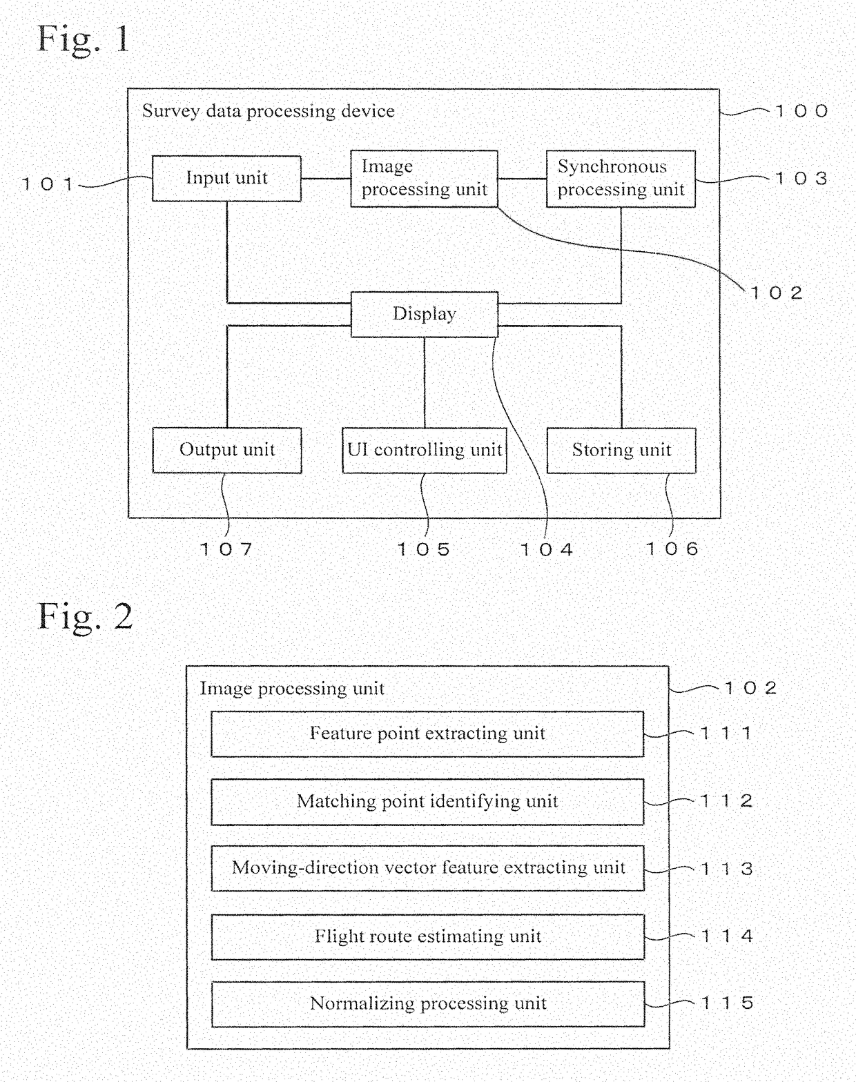
[0059]FIG. 6 shows an example of a processing procedure. When the processing is started, image data is input (step S101), and the log data is also input (step S102). After the image data is input, feature points are extracted in each of the still images (step S103). The processing of this step is performed by the feature point extracting unit 111 shown in FIG. 2. After the feature points are extracted, the feature points, which match between still images that are photographed in a consecutive manner, are identified (step S104). The processing of this step is performed by the matching point identifying unit 112.

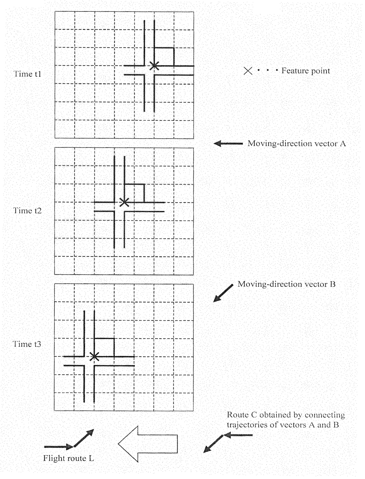
[0060]After the matching points are identified, features of moving-direction vectors are extracted by using the method exemplified in FIG. 5 (step S105). The processing of this step is performed by the moving-direction vector feature extracting unit moving direction vector feature extracting unit 113 shown in FIG. 2. Next, the procedure advances to step S106, and a flight rout...


PUM


Abstract

An operation burden in confirming a corresponding relationship between multiple still images and a traveled route is reduced. A survey data processing device includes a storing unit 106 and a UI controlling unit 105. The storing unit 105 stores survey data, in which image data of multiple still images that are photographed from a mobile body while flying is correlated with a flight route of the mobile body. The UI controlling unit 105 displays the flight route and at least one of the multiple still images on a screen. The displayed flight route and the displayed still image are displayed on the same screen at the same time in a condition in which a corresponding relationship between the flight route and the multiple still images is determined, and a moving direction of the mobile body that photographed the displayed still image is indicated in the displayed still image.

Description

BACKGROUND OF THE INVENTION[0001]Technical Field[0002]The present invention relates to a surveying technique.[0003]Background Art[0004]For example, a technique for obtaining a three-dimensional model of the topography of an object based on image data (three-dimensional topographic data in which the topography of the object is modeled as electronic data) is publicly known (for example, refer to Japanese Unexamined Patent Application Laid-Open No. 0000-00005). The image data may be obtained by photographing a civil engineering worksite or the like from the air. In such a technique, information of photographing locations must be linked with the photographing data.[0005]In the above technique, a method of using an autonomously flying unmanned air vehicle (UAV) equipped with a camera may be used. In this case, a relationship between an obtained still image (frame image in the case of using a moving image) and a location and an attitude of the camera (UAV) must be obtained.SUMMARY OF THE ...

Claims


Application Information

Patent Timeline
Patent Type & Authority Patents(United States)
IPC IPC(8): H04N5/232G06T1/00G01C21/00G01C11/06G06F3/0481
CPCH04N5/23222G01C11/06G01C21/005G06F3/0481G06T1/0007B64C2201/123G06T2200/24B64U2101/30H04N23/64
Inventor SASAKI, DAISUKEFUKAYA, NOBUYUKIOOTANI, HITOSHIOSARAGI, KAZUKISASAKI, TAKESHIANAI, TETSUJI
Owner KK TOPCON
Why Eureka
Try Eureka