Method for rapidly modeling of urban street base on image sequence

A technology of image sequences and urban blocks, which is applied in the field of rapid modeling of urban blocks based on image sequences, can solve the problems of complex collection equipment, too many model patches, and high cost, and achieve convenient data collection and simple interaction Effect

Inactive Publication Date: 2008-12-24
ZHEJIANG UNIV
View PDF0 Cites 27 Cited by
  • Summary
  • Abstract
  • Description
  • Claims
  • Application Information

AI Technical Summary

Problems solved by technology

This method can obtain accurate models, but the acquisition equipment is relatively complicated and expensive
[0006] 4. 3D reconstruction methods based on computer vision: such as Marc Polleveys, David Nistér and others' Detailed Real-Time Urban 3D Rec

Method used


Image

  • Method for rapidly modeling of urban street base on image sequence
  • Method for rapidly modeling of urban street base on image sequence

Examples


Embodiment Construction

[0021] The present invention will be further described below in conjunction with the accompanying drawings and embodiments.

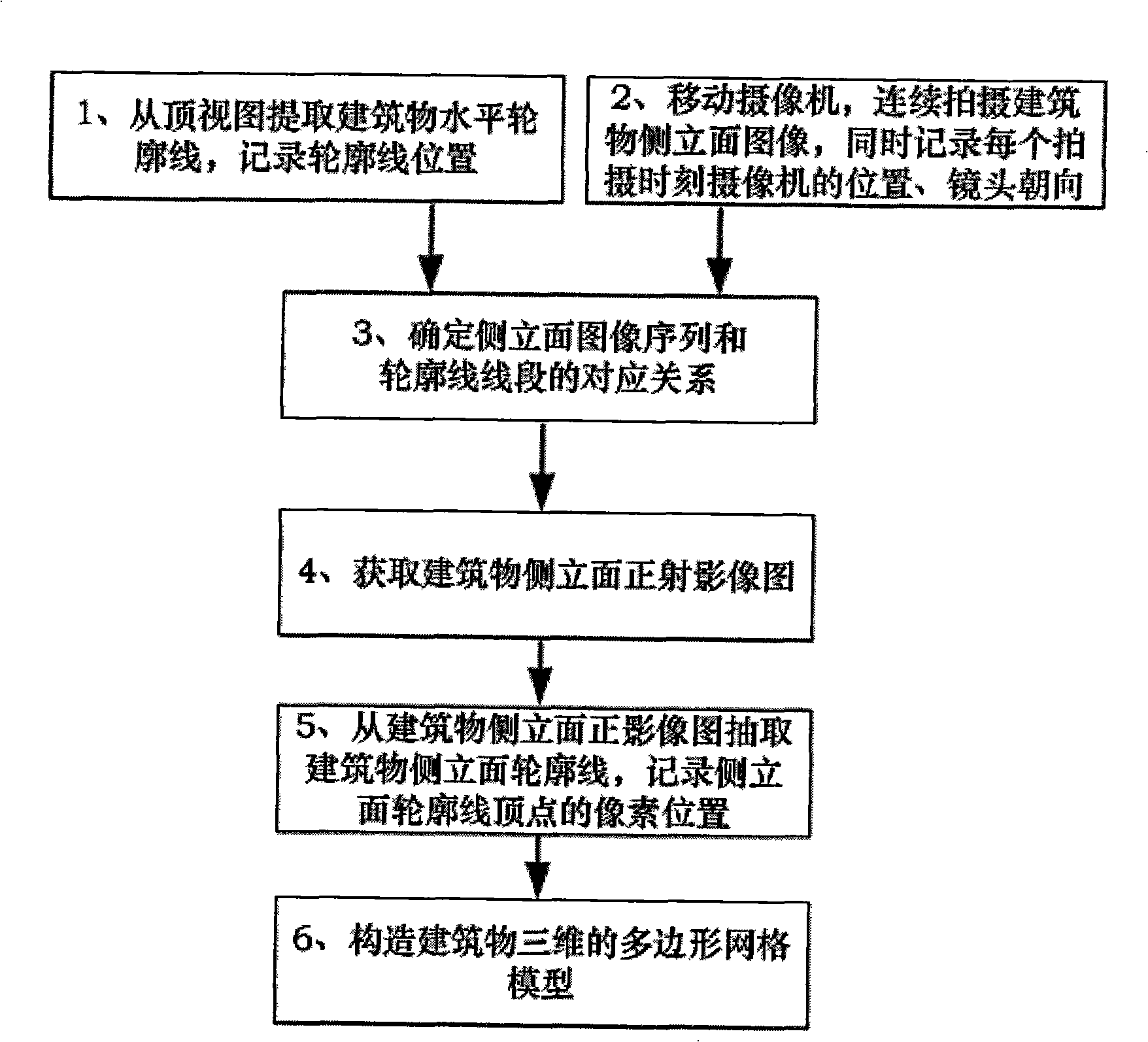
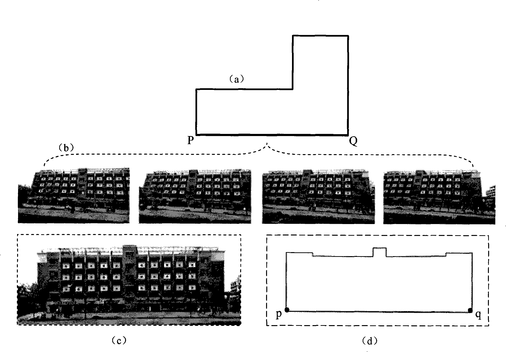
[0022] The present invention proposes an efficient and fast method for urban modeling, including six steps: first, extract the horizontal outline information of buildings from top views such as aerial images or urban planning drawings; at the same time, use cameras to obtain building side elevation image sequences And record the camera position and lens orientation at each shooting moment, and then determine the correspondence between the building's horizontal contour line segment and the building's side elevation image sequence; then use the side elevation image sequence to generate the building's side elevation orthophoto map , then determine the contour line of the side elevation on the orthophoto map, calculate the height of the side elevation of the building, and finally integrate the geometric and texture information of the horizontal contour line ...


PUM


Abstract

The invention discloses a rapid modeling method of urban blocks based on image sequences. The method comprises six steps: firstly, horizontal contour information of buildings is extracted from the top views of aerial photographing images or urban planning maps, and side elevation image sequences are acquired by a camera and the positions of the camera at each photographing moment and the directions of lens are recorded; secondly, the correspondence between segments of the horizontal contour lines of the buildings and the image sequences of the side elevations of the buildings are defined, and the image sequences of the side elevations of the buildings are utilized to generate positive projection images of the side elevations of the buildings, and then the side elevation contour lines are defined on the positive projection images and the height of the side elevations of the buildings is calculated, and finally a complete three-dimension model is obtained by integrating geometrical and textile information of the horizontal contour lines of and the side elevation contour lines of the buildings. Aims at overcoming the shortcomings of the prior art, the method of the invention proposes the urban modeling method integrating the top views and the image sequences of the side elevations of the buildings; the method of the invention needs no special expensive hardware equipment, and the interaction manner is simple and the data collecting manner is rather convenient.

Description

technical field [0001] The invention relates to a method for three-dimensional reconstruction generally based on image / video data, in particular to a method for fast modeling of city blocks based on image sequences. Background technique [0002] Current common urban 3D modeling theories and methods: [0003] 1. Manual interactive modeling: Use modeling tools such as 3ds max to construct the geometric model of the building, and use image processing tools such as Photoshop to edit the collected texture data to obtain ideal textures. This method is still the most reliable and practical way of urban modeling, but it is time-consuming and labor-intensive, and the efficiency is not high. [0004] 2. Photogrammetry, such as commercial software Photomodeler, etc., shoots the target object from various directions, and selects and determines the corresponding points, lines and other information on different viewpoint images, and then uses the principle of photogrammetry to obtain the...

Claims


Application Information

Patent Timeline
IPC IPC(8): G06T17/00G06T15/00G01C11/00
Inventor 华炜鲍虎军张艺江
Owner ZHEJIANG UNIV
Why Eureka
Try Eureka