City ground impermeability degree analyzing and drawing method

A water-permeable, urban technology, applied in the direction of electromagnetic wave re-radiation, re-radiation, measurement devices, etc., can solve the problems of complex urban structure, time-consuming, labor-intensive, high cost, etc., and achieve the effect of simple technical process, high efficiency and improved efficiency

Inactive Publication Date: 2009-04-08
BEIJING JIAOTONG UNIV
View PDF0 Cites 10 Cited by
  • Summary
  • Abstract
  • Description
  • Claims
  • Application Information

AI Technical Summary

Problems solved by technology

This method is mainly based on manual visual interpretation, which is time-consuming, labor-intensive, costly, and inefficient
The other is the pixel-based remote sensing image classification method. Due to the complex structure of the urban area, the same object wit

Method used


Image

  • City ground impermeability degree analyzing and drawing method
  • City ground impermeability degree analyzing and drawing method
  • City ground impermeability degree analyzing and drawing method

Examples


Embodiment Construction

[0029] The present invention will be further described in detail below in conjunction with the accompanying drawings and specific embodiments.

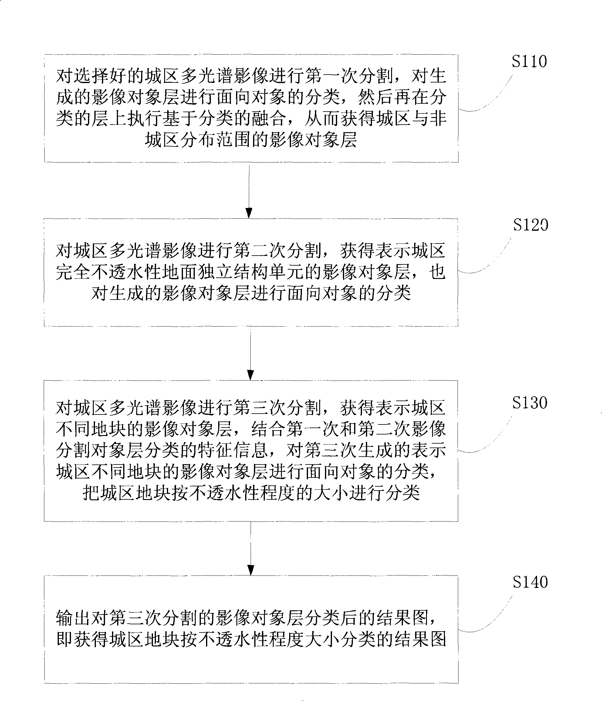
[0030] figure 1 It is a flow chart of the urban ground impermeability degree analysis and drawing method of the first embodiment of the present invention, as figure 1 shown, including the following steps:

[0031] Segment the multispectral image of the selected urban area for the first time, perform object-oriented classification on the generated image object layer, and then perform classification-based fusion on the classified layer to obtain image objects in the distribution range of urban and non-urban areas layer (S110).

[0032] The second segmentation is performed on the multispectral image of the urban area to obtain an image object layer that can represent the independent structural unit of the completely impermeable ground in the urban area, and an object-oriented classification is also performed on the generated image obje...


PUM


Abstract

The invention discloses an analyzing and charting method of urban land water impermeability degree, which comprises the following steps: a chosen urban multispectral remote sensing image is segmented for the first time, object-oriented classification is carried out on image object layer which is produced, and classification-based fusion is performed on the classified layer, thereby obtaining image object layer in urban and non-urban distributing areas (S110); the remote sensing image is segmented for the second time to obtain an image object layer which indicates absolute construction unit of fully impermeable urban land, and object-oriented classification is carried out on the image object layer (S120); the remote sensing image is segmented for the third time to obtain an image object layer which indicates different land parcels in urban area, and object-oriented classification is carried out on the image object layer with combination of characteristic information of the first and the second classification of the segmented image object layer (S130); after the image object layer segmented for the third time is classified, a result picture is output, thereby obtaining a result picture that urban land parcels are classified by water impermeability degree (S140).

Description

technical field [0001] The invention relates to a method for analyzing and drawing the degree of water impermeability of urban ground, which belongs to the application fields of urban development planning, urban surveying and mapping, and urban remote sensing technology. Background technique [0002] It is well known that the analysis and mapping of urban ground imperviousness is extremely important for understanding the development of urban areas, formulating future urban planning, and evaluating the environmental quality and living suitability of urban areas. Currently, two methods are used for mapping the degree of imperviousness of the urban ground. One is the method of remote sensing visual interpretation mapping. This method first determines the scope of the urban area to be analyzed, and then classifies and outlines various urban impermeable surfaces in the urban area, such as roads, buildings, parking lots, etc., as well as water permeability. Ground, such as grassl...

Claims


Application Information

Patent Timeline
IPC IPC(8): G01S17/89
CPCG06K9/00637G06V20/176
Inventor 谭衢霖魏庆朝杨松林胡吉平师红云王斌
Owner BEIJING JIAOTONG UNIV
Why Eureka
Try Eureka