Remote monitoring system for disaster of mountain massif coast

A technology for remote monitoring and landslides, applied in signal transmission systems, non-electrical signal transmission systems, instruments, etc., can solve problems such as difficult to reliably characterize the actual state and level of landslides, difficult to put into engineering implementation, and inconvenient installation and construction, etc., to achieve Low node cost, small environmental impact, and good real-time effect

Inactive Publication Date: 2009-06-10
WUHAN UNIV
View PDF3 Cites 45 Cited by
  • Summary
  • Abstract
  • Description
  • Claims
  • Application Information

AI Technical Summary

Problems solved by technology

The displacement sensor is a traction wire installed on the active slope, using various direct or indirect displacement sensors, such as angle sensors, telescopic displacement sensors to sense the displacement of the active slope relative to the stable slope, and there are installations for such sensors. The problem of inconvenient construction
The use of ordinary GPS technology to monitor landslides and collapses has low measurement accuracy. If static differential GPS technology is used, the equipment price is relatively high
[0007] In particular, it should be pointed out that due to the suddenness and randomness of landslides and the complexity of the evolution process of landslides, a small number of displacement sensors are arranged in the monitoring area, and their sampling distribution is difficult to reliably represent the actual state and grade of landslides.
On the contrary, a large number of displacement sensors and GPS global satellite positioning devices are arranged, because of the risk of being submerged by sliding bodies, rockslides, and being smashed, whether it is use cost, communication or energy consumption, it will become a bottleneck factor, and it is difficult to put it into engineering implementation

Method used


Image

  • Remote monitoring system for disaster of mountain massif coast
  • Remote monitoring system for disaster of mountain massif coast
  • Remote monitoring system for disaster of mountain massif coast

Examples


Embodiment Construction

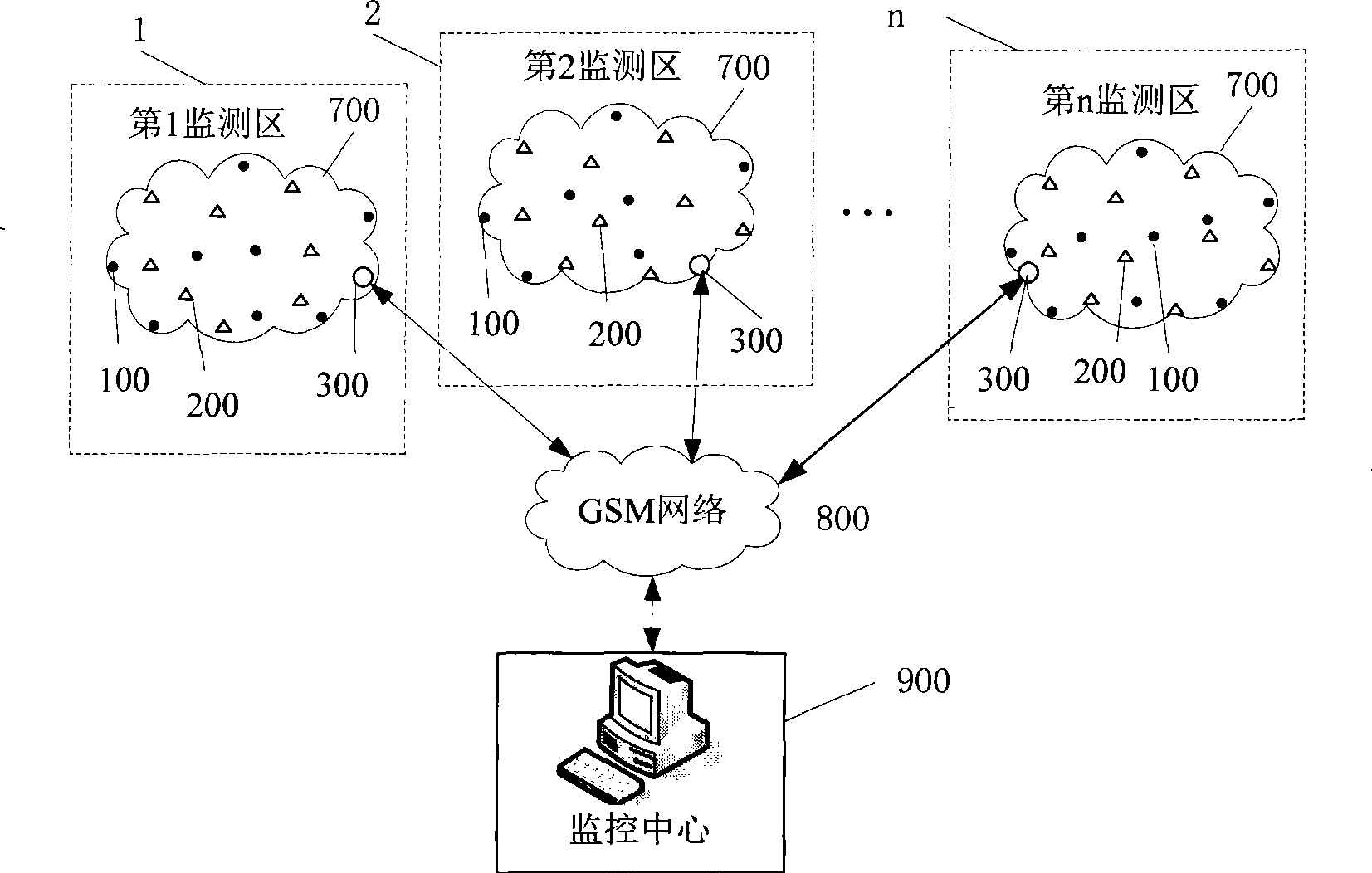
[0068] Below in conjunction with accompanying drawing and embodiment, the present invention is further described:

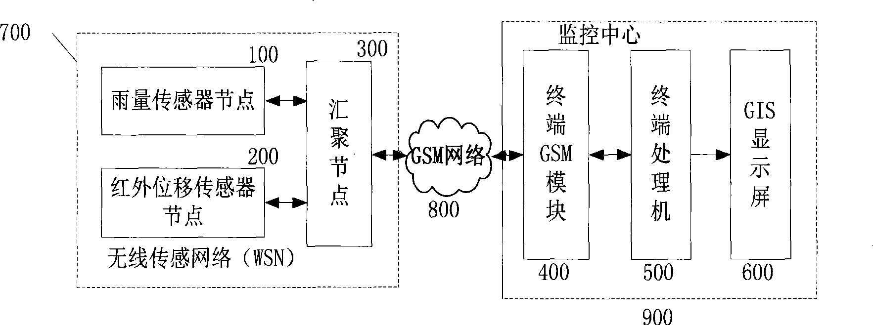
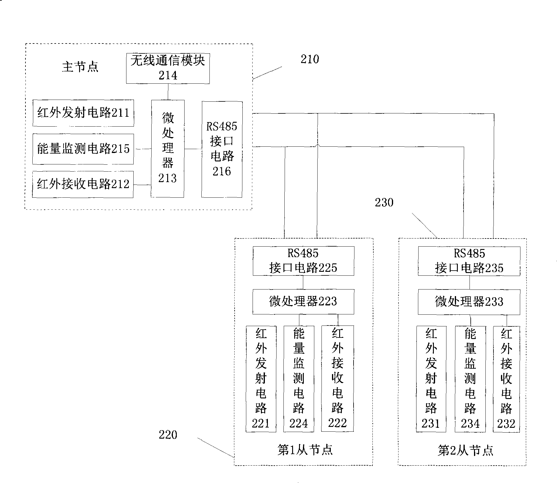
[0069] 1. Functional blocks

[0070] 1. Rain sensor nodes (100)

[0071] According to the range and environment of the monitoring sub-areas, 1 to n number of rain sensor nodes (100) are arranged in each monitoring sub-area, and the sensor nodes are composed of rain-measuring sensitive head, signal conditioning circuit, microprocessor, memory, wireless communication It is composed of several parts with the energy supply module. After the rain-measuring sensitive head converts the perceived rainfall change into an electrical signal, it is sent to the microprocessor for A / D conversion through the signal conditioning circuit, and the preset software is used to identify and accumulate rainfall, and the data is transmitted through the wireless communication module. send it out.

[0072] The rain sensor node (100) is powered by a high-energy secondary lithium battery...


PUM


Abstract

The invention discloses a landslide disaster remote monitoring system, and relates to a landslide monitoring system. The structure of the landslide disaster remote monitoring system comprises the following: a rainfall sensor node (100) and an infrared displacement sensor node (200) are connected with a convergent node (300) respectively to form a wireless sensing network (700), and the wireless sensing network (700), a GSM/GPRS network (800), a terminal GSM/GPRS module (400), a terminal processor (500), and a GIS display screen (600) are connected in turn. The landslide disaster remote monitoring system is used for real-time monitoring of actual rainfall intensity and rainfall duration of landslide and collapse areas, state information of landslide and collapse, and sliding information of dangerous rocks, can objectively and comprehensively monitor and evaluate the rainfall threshold of critical landslide, the evolutive process and the state of landslide, and the landslide and collapse level, and provides a novel real-time monitoring path for landslide and collapse early alarm.

Description

technical field [0001] The invention relates to a landslide monitoring system, in particular to a remote monitoring system for landslide disasters based on a wireless sensor network. Background technique [0002] Landslides and collapses are one of the main natural disasters in mountainous areas. They not only cause huge losses to industrial and agricultural production and people's lives and property, but also cause great harm to railways, highways, water conservancy and hydropower projects, etc. The occurrence and development of landslides are not only controlled by the formation conditions (topography, geological lithology, geological structure, hydrogeological conditions, etc.), but also affected by inducing factors (rainfall, human activities, etc.). Torrential rain, especially continuous heavy rainfall, is one of the important factors causing landslides, so rainfall information is an important basis for monitoring landslide geological hazards. In addition, the state h...

Claims


Application Information

Patent Timeline
Patent Type & Authority Applications(China)
IPC IPC(8): G08C17/00G08C23/00H04L12/28
Inventor 王海华熊昌仑夏晓珣谢辉谭福耀
Owner WUHAN UNIV
Why Eureka
Try Eureka