Unknown-node locating method based on underground wireless sensor network

A wireless sensor and unknown node technology, applied in the field of self-location of unknown mobile nodes, can solve the problems of low positioning accuracy, instability, and high node cost, and achieve the effects of low node cost, improved positioning accuracy, and easy implementation

Inactive Publication Date: 2015-07-01
NANJING UNIV OF POSTS & TELECOMM
View PDF3 Cites 0 Cited by
  • Summary
  • Abstract
  • Description
  • Claims
  • Application Information

AI Technical Summary

Problems solved by technology

However, the accuracy of RSSI ranging is often sensitive to the harsh electromagnetic environment caused by underground narrow roadways, operating machinery or locomotives, resulting in low positioning accuracy and instability. At the same time, the cost of nodes with RSSI ranging function is also relatively high.
2. For the distance-independent positioning method, although its node cost is relatively low, the narrow and long underground roadway structure also seriously restricts the accuracy of the existing distance-independent positioning method. The reason is that the existing distance-independent or range-free positioning The method, such as the distance vector-hop number (Dv-Hop) method, is to estimate the distance between the unknown node and the beacon node by estimating the hop distance of a single hop and combining the hop number to achieve further positioning, and the narrow and long space structure only occupies a fixed number of nodes. It is difficult for about 10% of the beacon nodes to play the reference role of their known positions in the direction of narrow width, which affects the positioning accuracy of unknown nodes

Method used


Image

  • Unknown-node locating method based on underground wireless sensor network
  • Unknown-node locating method based on underground wireless sensor network
  • Unknown-node locating method based on underground wireless sensor network

Examples


Embodiment 1

[0050] Embodiment 1: Simulation experiment of distance-independent positioning of a section of horizontal shaft roadway in an underground mine.

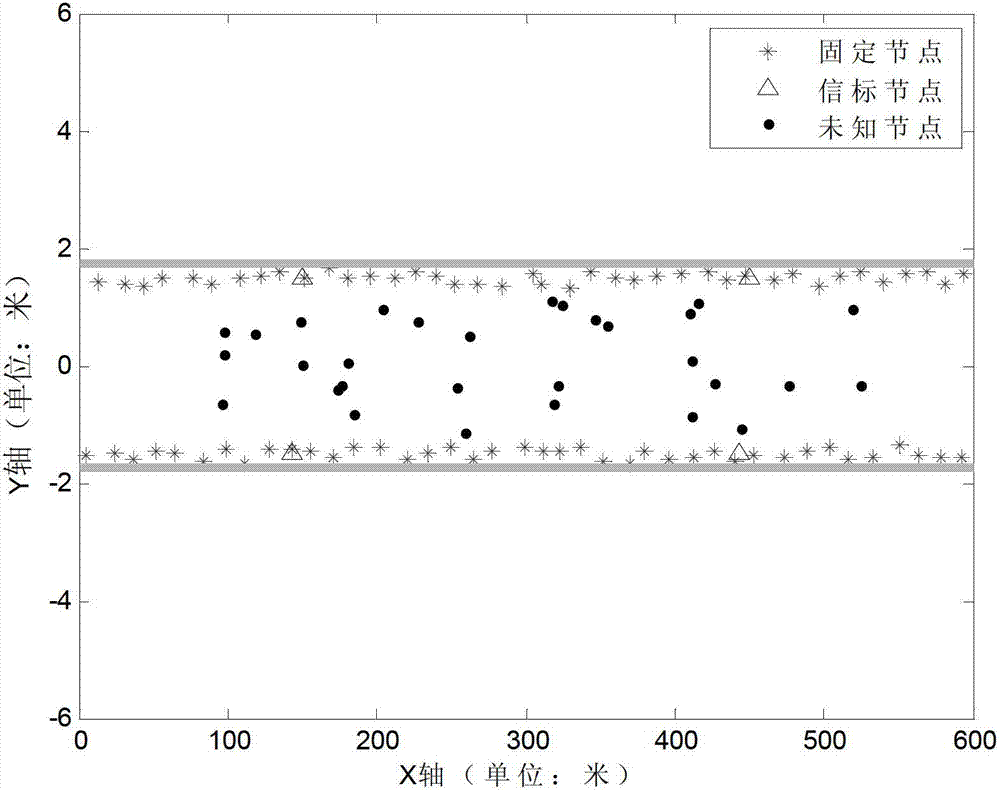
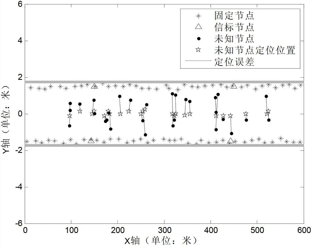
[0051] The distribution of nodes in the simulation experiment is as follows: figure 1 As shown, the x and y axes are the length and width directions of the horizontal well roadway respectively. The roadway is 600 meters long and 3.5 meters wide. The two thick solid lines parallel to the x-axis in the figure represent the roadway wall, and 80 "*" represent the roadway along the roadway. Fixed nodes placed on the wall with low precision, 4 "△" indicate beacon nodes with known positions, and beacon nodes are also arranged along the roadway wall, 30 "◆" represent unknown nodes randomly distributed in the roadway, adjacent fixed nodes The average distance between nodes along the x-axis direction D x =15m, the average distance along the y-axis direction D y = 3m, the deployment error of the fixed node along the x-axis and y-axis directio...

Embodiment 2

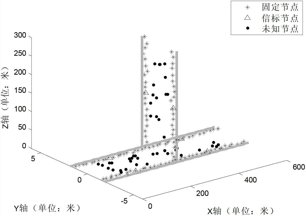
[0052] Embodiment 2: Simulation experiment of distance-independent positioning in underground roadway with branches.

[0053] The distribution of nodes in the simulation experiment is as follows: image 3 As shown, the roadway is composed of a section of horizontal shaft and a section of intersecting vertical shaft. The horizontal shaft is 600 meters long along the x-axis direction, and the vertical shaft is 300 meters long along the z-axis direction. The placement interval and placement error are the same as in Embodiment 1. The positioning result of embodiment 2 is as follows Figure 4 As shown, "☆" indicates the positioning result of the unknown node, and the positioning result and the unknown node are also connected by a solid line. It can be calculated that the average positioning error of the present invention is about 1.78m, and the average positioning accuracy relative to the communication distance is 0.036. It can be seen that the present invention also has higher ...


PUM


Abstract

The invention discloses an unknown-node locating method based on an underground wireless sensor network. The method belongs to the field of node locating for the underground wireless sensor network. The method comprises firstly distributing fixed nodes in a staggered mode on two sides of the roadway from the entrance of the roadway to the tail of the roadway at intervals along the length direction of an underground roadway, distributing a unique ID number to each fixed node, calculating the relative positions of the fixed nodes in the roadway according to the ID number of a fixed node 1 hop count away from the unknown node so as to achieve self-locating of the unknown node. The unknown-node locating method based on the underground wireless sensor network can achieve node locating at the intersecting position of the roadways without accurately placing the fixed nodes, and is high in locating precision, low in calculation and easy to implement.

Description

technical field [0001] The invention relates to a method for self-locating an unknown mobile node based on an underground roadway wireless sensor network, and belongs to the field of underground wireless sensor network node positioning. Background technique [0002] Underground environmental monitoring such as coal mines has always been one of the key contents in the field of safety monitoring. With the wide application of wireless sensor network technology, underground wireless sensor network technology has made great progress. However, the underground electromagnetic environment is complex and harsh, and key issues such as node positioning have not been well resolved. In order to improve the efficiency and reliability of the underground wireless sensor network, node positioning for the underground environment is very necessary. [0003] At present, wireless sensor network node positioning mainly includes two methods based on ranging and distance-independent. 1. For the po...

Claims


Application Information

Patent Timeline
Patent Type & Authority Patents(China)
IPC IPC(8): H04W64/00H04W84/18G01S5/02
Inventor 邱晓晖
Owner NANJING UNIV OF POSTS & TELECOMM
Why Eureka
Try Eureka