Multiple kinds of interference suppression method of universal satellite navigation system

A satellite navigation system, interference suppression technology, applied in the field of satellite navigation system interference suppression, to achieve the effect of ensuring normal operation, reducing multipath signals, and good compatibility

Inactive Publication Date: 2011-07-06
CIVIL AVIATION UNIV OF CHINA
View PDF3 Cites 0 Cited by
  • Summary
  • Abstract
  • Description
  • Claims
  • Application Information

AI Technical Summary

Problems solved by technology

When these three types of interference coexist, since the spoofed interference has the same characteristics as the navigation satellite signal, the blind adaptive beamforming method using the characteristics of the navigation satellite signal is invalid. When the multipath interference of the satellite signal exists, the power inversion method is also invalid.

Method used


Image

  • Multiple kinds of interference suppression method of universal satellite navigation system
  • Multiple kinds of interference suppression method of universal satellite navigation system
  • Multiple kinds of interference suppression method of universal satellite navigation system

Examples


Embodiment Construction

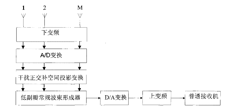
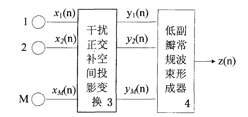
[0029] x ( t ) = Σ l = 1 L ( a l s l ( t ) + Σ p = 1 P a lp s lp ( t - τ lp ) + Σ k = 1 K a lk s lk ( t - τ lk ...


PUM


Abstract

The invention discloses a method for inhibiting various interferences of a universal satellite navigation system. The method is realized by utilizing an self-adaptive array antenna to inhibit interference; the method comprises the following steps: converting an analog radio-frequency signal received by an array antenna into a digital intermediate frequency signal; projecting the converted digitalintermediate frequency data on an interference orthocomplementation space; carrying out low side lobe routine wave beam on the projected data to form inhibit multipath; calculating an array weightingvector; and after the wave beam is formed, converting a satellite navigation signal into the analog radio-frequency signal, and sending the analog radio- frequency signal to a receiver. Interference inhibition through utilization of the self-adaptive array antenna is realized by embedding a secondary interference processor between array antenna and the receiver of the satellite navigation system and does not change an inner structure of the receiver of the satellite navigation system. The method does not need to change the inner structure of a common navigation receiver, has good compatibility with the prior receiver, can ensure the normal operation of the satellite navigation receiver under the condition of coexistence of common deceptive type interference, pressing type interference andsatellite multipath interference.

Description

technical field [0001] The invention relates to a satellite navigation system interference suppression method. In particular, it relates to a general satellite navigation system multi-type interference suppression method capable of suppressing various types of interference without changing the receiver structure of the existing satellite navigation system. Background technique [0002] The satellite navigation system is a satellite-based radio navigation system that uses artificial satellites as the navigation platform. It can provide high-precision three-dimensional position, speed and time information for any place in the world at all times and all weathers, thus fundamentally changing the navigation of many industries. The positioning pattern and level provide convenience and security for countless sea, land, air, and space military and civilian users. It has become an important infrastructure of the information system and a key technical support system directly related ...

Claims


Application Information

Patent Timeline
Patent Type & Authority Patents(China)
IPC IPC(8): G01S5/02
Inventor 卢丹吴仁彪李婵
Owner CIVIL AVIATION UNIV OF CHINA
Why Eureka
Try Eureka