Method for radiometric correction of remote sensing image taken by rotary scan multiple parallel-scan infrared camera

A technology of infrared camera and remote sensing image, applied in the aerospace field

Active Publication Date: 2009-08-26
CHINA CENT FOR RESOURCES SATELLITE DATA & APPL
View PDF0 Cites 27 Cited by
  • Summary
  • Abstract
  • Description
  • Claims
  • Application Information

AI Technical Summary

Problems solved by technology

Due to the first use of double-sided mirror rotation multi-element parallel scanning imaging, at present, there is no radiation correction processing flow and algorithm for direct reference in China, which needs independent research and development.

Method used


Image

  • Method for radiometric correction of remote sensing image taken by rotary scan multiple parallel-scan infrared camera
  • Method for radiometric correction of remote sensing image taken by rotary scan multiple parallel-scan infrared camera
  • Method for radiometric correction of remote sensing image taken by rotary scan multiple parallel-scan infrared camera

Examples


Embodiment Construction

[0022] see figure 1 , figure 2 , image 3 , Figure 4 , Figure 5 , Figure 6 .

[0023] The technical solutions of the present invention will be further described below in conjunction with the accompanying drawings and specific embodiments.

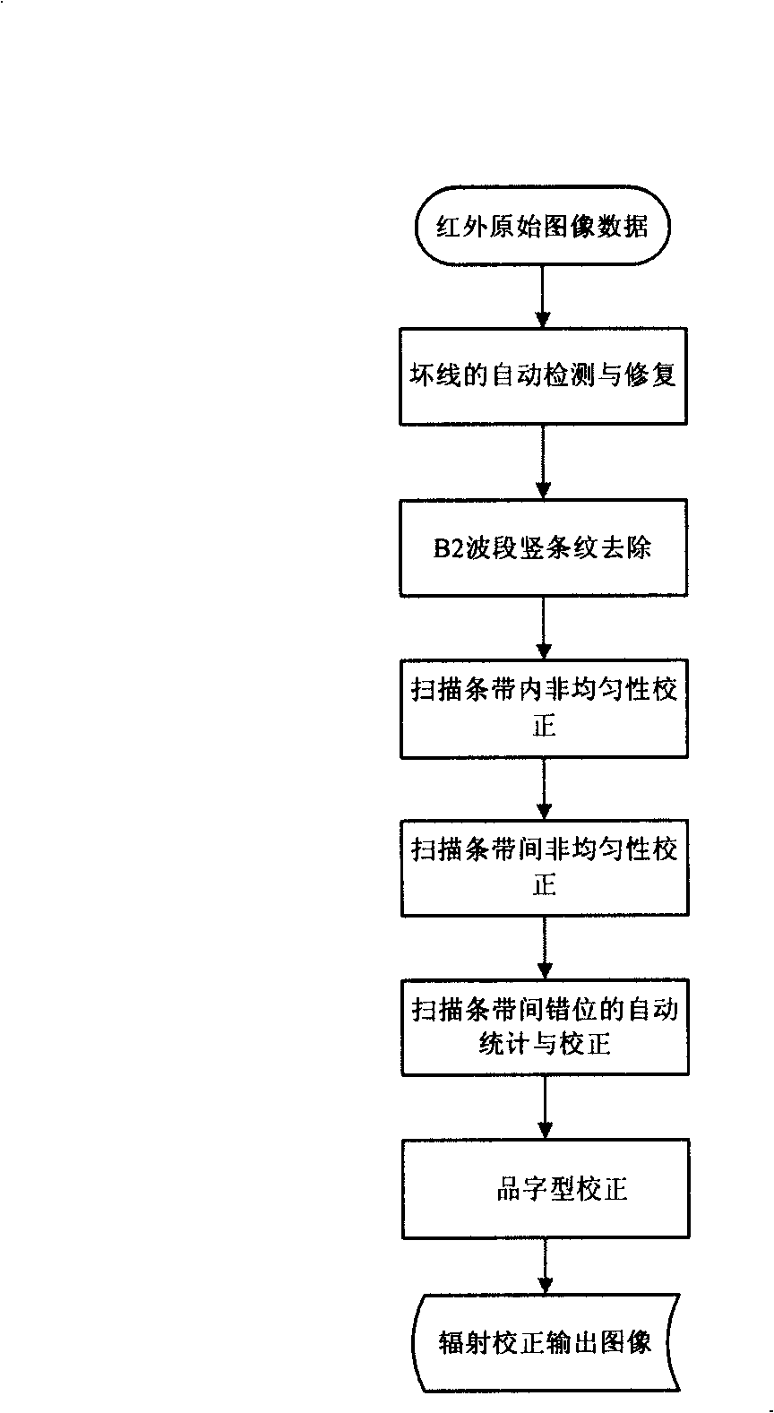
[0024] The present invention adopts figure 1 The flow chart of the radiation correction method for remote sensing images of the HJ-1B infrared camera is shown, and the specific implementation steps are as follows:

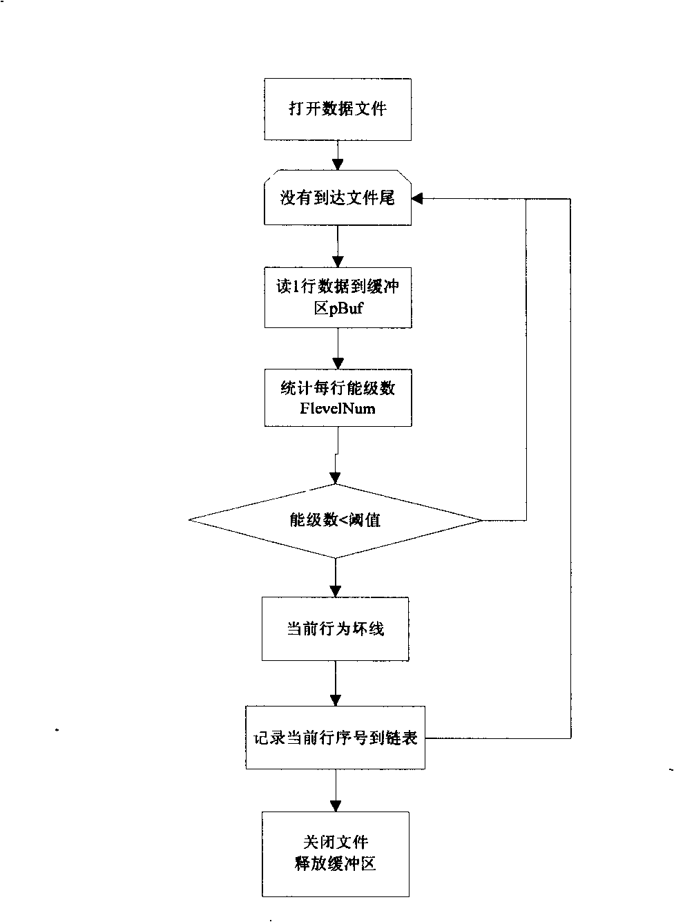
[0025] 1. Automatic detection and repair of dead and dummy pixels based on "DN value mapping-energy level statistics" algorithm

[0026] On the HJ-1B infrared image, the dead pixels appear as uniformly spaced scanning bands with bad pixels, and the gray value of the pixels is almost zero. Abnormal, either high or low.

[0027] The energy level statistical method is used to detect dead pixels and dummy pixels. The algorithm principle is: in the same scan line, the DN value of normal pixels has more quantitative energ...


PUM


Abstract

The invention discloses a ground data processing method for the radiometric correction of a remote sensing image taken by a double-sided mirror rotary multiple parallel-scan infrared camera. The method is based on the imaging principle of the double-sided mirror rotary multiple parallel-scan of an HJ-1B infrared camera, and solves the actual engineering problem of the data processing in a satellite ground system; the position of a damaged line is automatically detected by a DN value mapping-energy level statistical method, and the image recovery is carried out by the linear interpolation; aiming at the unevenness in a scan band caused by the multiple parallel-scan and the unevenness among the bands caused by the double-sided mirror scan, the multipoint piecewise linear interpolation fitting algorithm and the two-point linear algorithm are adopted for correction; aiming at the image dislocation between the adjacent scan bands caused by the double-sided mirror scan, the algorithm for minimizing the difference value of adjacent pixels is adopted for correction; and aiming at a vertical stripe appeared on the B2 waveband of the infrared camera after the satellite is launched, the first derivative gradient value method is adopted for automatic detection and recovery, thereby effectively eliminating the stripe and obviously improving the image quality.

Description

technical field [0001] The invention belongs to the ground system processing algorithm technology in the field of aerospace, and mainly relates to a remote sensing image radiation correction processing algorithm of a double-sided mirror rotating multi-element parallel scanning imaging mode infrared camera. Background technique [0002] The HJ-1B infrared camera, which was launched into orbit on September 8, 2008, uses a dual-mirror rotating multi-element parallel-scan imaging method. This imaging method is currently used in satellite remote sensors for the first time in China. According to its imaging mechanism and the unique problems encountered after the camera enters orbit, it is required to consider the particularity of many aspects in the image radiation correction of the ground system, such as the character font correction between the detectors, and the difference in the AB surface response of the scanning mirror. Correction, misalignment correction in the long axis di...

Claims


Application Information

Patent Timeline
Patent Type & Authority Applications(China)
IPC IPC(8): H04N1/409H04N5/217
Inventor 郭建宁李照洲王海燕
Owner CHINA CENT FOR RESOURCES SATELLITE DATA & APPL
Why Eureka
Try Eureka