Method for navigating and positioning aerocraft based on landmark capturing and tracking

A technology of navigation and positioning and aircraft, which is applied in the direction of navigation through speed/acceleration measurement, navigation calculation tools, etc., can solve the problems of increasing the cost of aircraft navigation and positioning, impossibility, limitations, etc., to achieve enhanced application versatility, improve positioning accuracy, good reliability

Inactive Publication Date: 2009-09-16
HUAZHONG UNIV OF SCI & TECH
View PDF0 Cites 34 Cited by
  • Summary
  • Abstract
  • Description
  • Claims
  • Application Information

AI Technical Summary

Problems solved by technology

There are two main problems with this method: additional laser rangefinder equipment is required, which increases the cost of aircraft navigation and positioning. Once the laser rangefinder fails, this method cannot be realized; on the other hand, this method is only applicable to planes. type landmarks, applications are limited

Method used


Image

  • Method for navigating and positioning aerocraft based on landmark capturing and tracking
  • Method for navigating and positioning aerocraft based on landmark capturing and tracking
  • Method for navigating and positioning aerocraft based on landmark capturing and tracking

Examples


Embodiment Construction

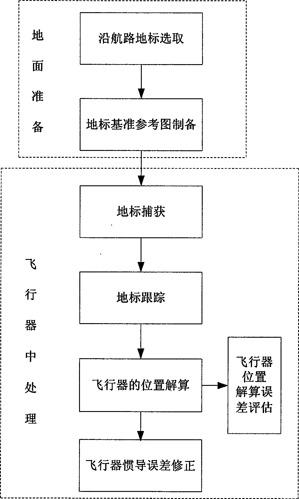
[0033] Reference below figure 1 To illustrate the steps of the present invention:

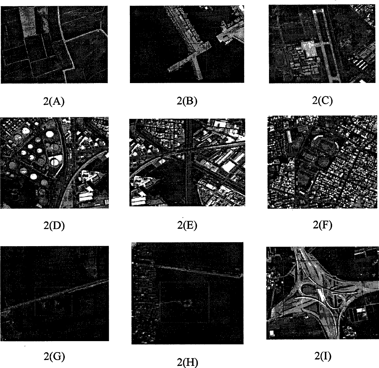
[0034] (1) Steps to select landmarks along the aircraft route: pre-plan the route and select the route with several landmarks. The landmarks should select those with significant structural features suitable for matching and recognition, that is, the contrast with the local background is obvious, and the features are not compared to the surrounding scene. Repeat pattern. Such as: bridge and river crossing area, highway crossing point, lake / sea islets, curved river channels and isolated buildings, etc. figure 2 Shown.

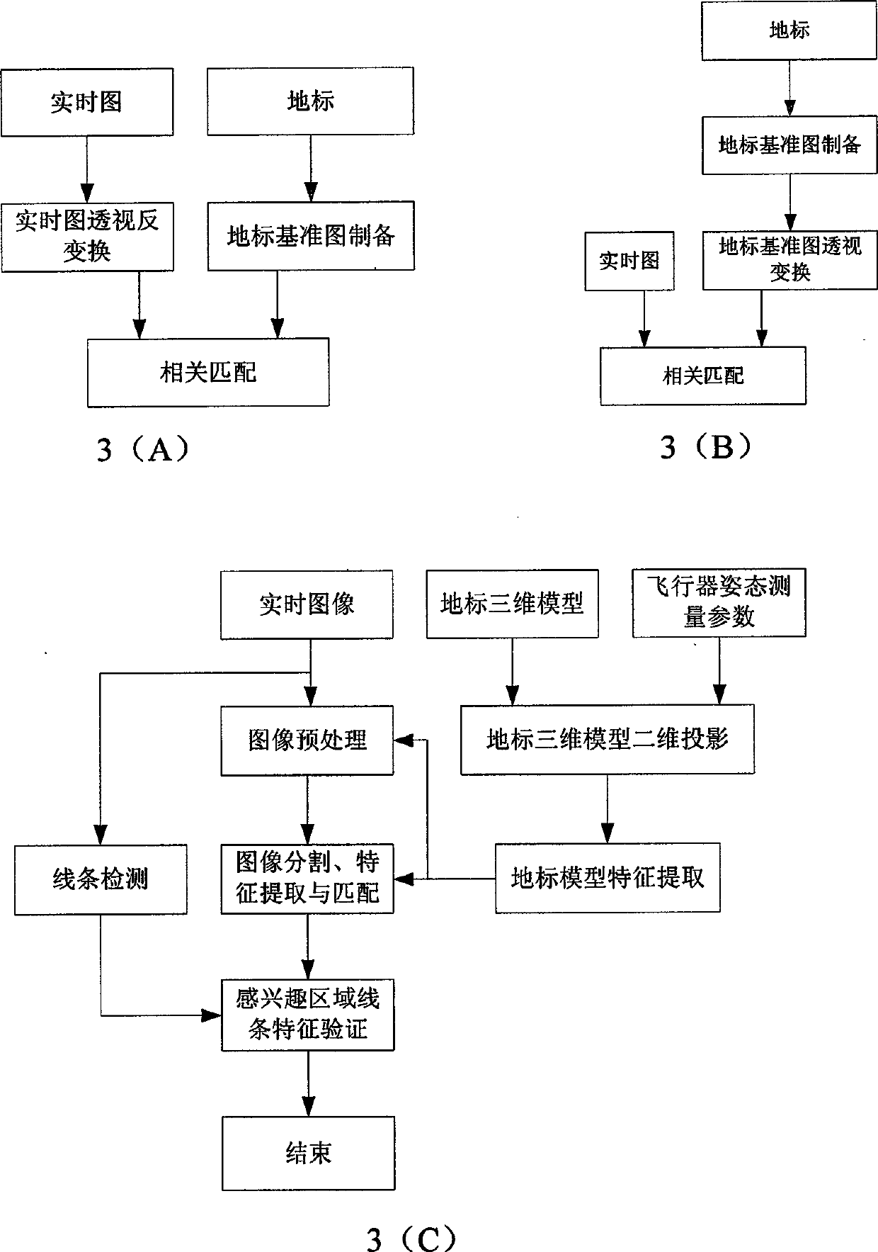
[0035] (2) Steps for preparing the landmark reference map: If the landmark is a flat landmark, the satellite images used to prepare the flat landmark reference map are taken from different weather, seasons and viewpoints, and different ground scenes have their own differences under different spectrums. There may be a big difference between the visible light and infrared imaging sens...


PUM


Abstract

The invention discloses a method for navigating and positioning an aerocraft based on landmark capturing and tracking, which belongs to the field of navigation and guidance for carrying out error correction on an aerocraft inertial navigation system. The method comprises that: the aerocraft captures a landmark along an airway, once the landmark is captured, aerocraft positioning is started. The aerocraft is positioned according to the following mode: acquiring measurement data related to the position of the aerocraft at time of t-delta t, t and t+delta t, and making the delta t more than zero second and less than 1 second; calculating coordinates of the aerocraft in a coordinate system of the landmark; calculating geodetic coordinates of the aerocraft according to the geodetic coordinates of the landmark; and finally, carrying out positioning and error correction on the inertial navigation system by the geodetic coordinates of the aerocraft. In the method, the type of the landmark can be plane type or solid type, can capture the landmark under the forward view or downward view imaging condition; and the position of the aerocraft can be calculated through adopting the measurement data of three adjacent sampling points so as to effectively improve the positioning precision with good reliability. Therefore, the method is suitable for navigating and positioning the aerocarft with a remarkable landmark in a flight path plan.

Description

Technical field [0001] The invention relates to the field of navigation and guidance, in particular to an aircraft navigation and positioning method. While capturing and tracking landmarks, the aircraft guidance system samples the aircraft's measurement data at certain time intervals, and automatically calculates the aircraft's coordinates at the landmarks based on the collected measurement data. According to the coordinates of the landmarks, the coordinates of the aircraft in the geodetic coordinate system are calculated. This method is used to correct the errors of the aircraft inertial navigation system to realize the precise navigation of the aircraft. Background technique [0002] Continuously improving the navigation accuracy of aircraft has always been an important research topic in the field of aerospace technology. The accumulated error of the inertial navigation system gradually increases with time. Therefore, relying on the inertial navigation system alone cannot meet ...

Claims


Application Information

Patent Timeline
Patent Type & Authority Applications(China)
IPC IPC(8): G01C21/20G01C21/16
Inventor 张天序杨效余杨卫东黎云钟胜颜露新桑农曹治国胡静邹腊梅王岳环左峥嵘
Owner HUAZHONG UNIV OF SCI & TECH
Why Eureka
Try Eureka