Method for automatically dividing display level of character marks in navigation electronic map and device thereof

A technology for displaying grades and electronic maps, which is applied to road network navigators and other directions, can solve the problems of rough division of display grades, reduce the readability of navigation electronic maps, display too much, etc., and achieve the effect of maintaining information load

Active Publication Date: 2010-02-24
NAVINFO
View PDF3 Cites 13 Cited by
  • Summary
  • Abstract
  • Description
  • Claims
  • Application Information

AI Technical Summary

Problems solved by technology

Because the display level division of text annotation is too rough, it is difficult to accurately describe the display difference requirements of text annotation only by dividing N levels, and it is impossible to distinguish the difference between any two different text annotations in display level
[0009] In the process of realizing the present invention, it is found that the prior art has at least the following problems: in the existing method for dividing the display level of text annotation, because the display level division of text annotation is not carried out according to the spatial structure relationship of text annotation , resulting in too much text annotation being displayed at one scale and less text annotation at another scale, reducing the readability of the navigation map

Method used


Image

  • Method for automatically dividing display level of character marks in navigation electronic map and device thereof
  • Method for automatically dividing display level of character marks in navigation electronic map and device thereof
  • Method for automatically dividing display level of character marks in navigation electronic map and device thereof

Examples


Embodiment 1

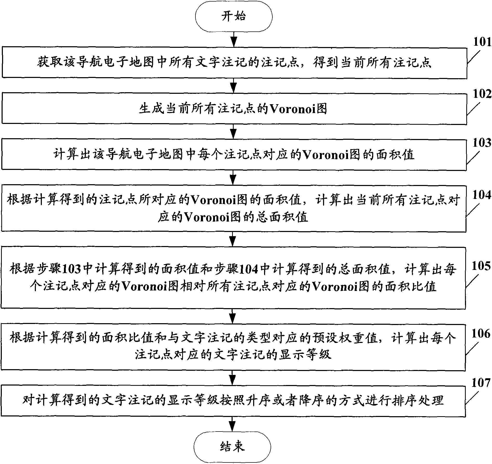
[0047] Such as figure 1 As shown, it is a flow chart of the automatic division method one of the text annotation display grade in the embodiment of the present invention, and the specific steps are as follows:

[0048] Step 101, obtaining all the annotation points of text annotation in the navigation electronic map, and obtaining all the current annotation points;

[0049]In this embodiment, since it is necessary to automatically classify the display levels of the text annotations in combination with the spatial distribution relationship of the text annotations, the spatial distribution of the text annotations can be obtained by generating Voronoi diagrams corresponding to all text annotations. The above annotation points are used to mark the text annotations in the electronic navigation map. At this time, the annotation points of all the text annotations in the electronic navigation map can be obtained by obtaining the coordinates of the annotation points.

[0050] Step 102,...

Embodiment 2

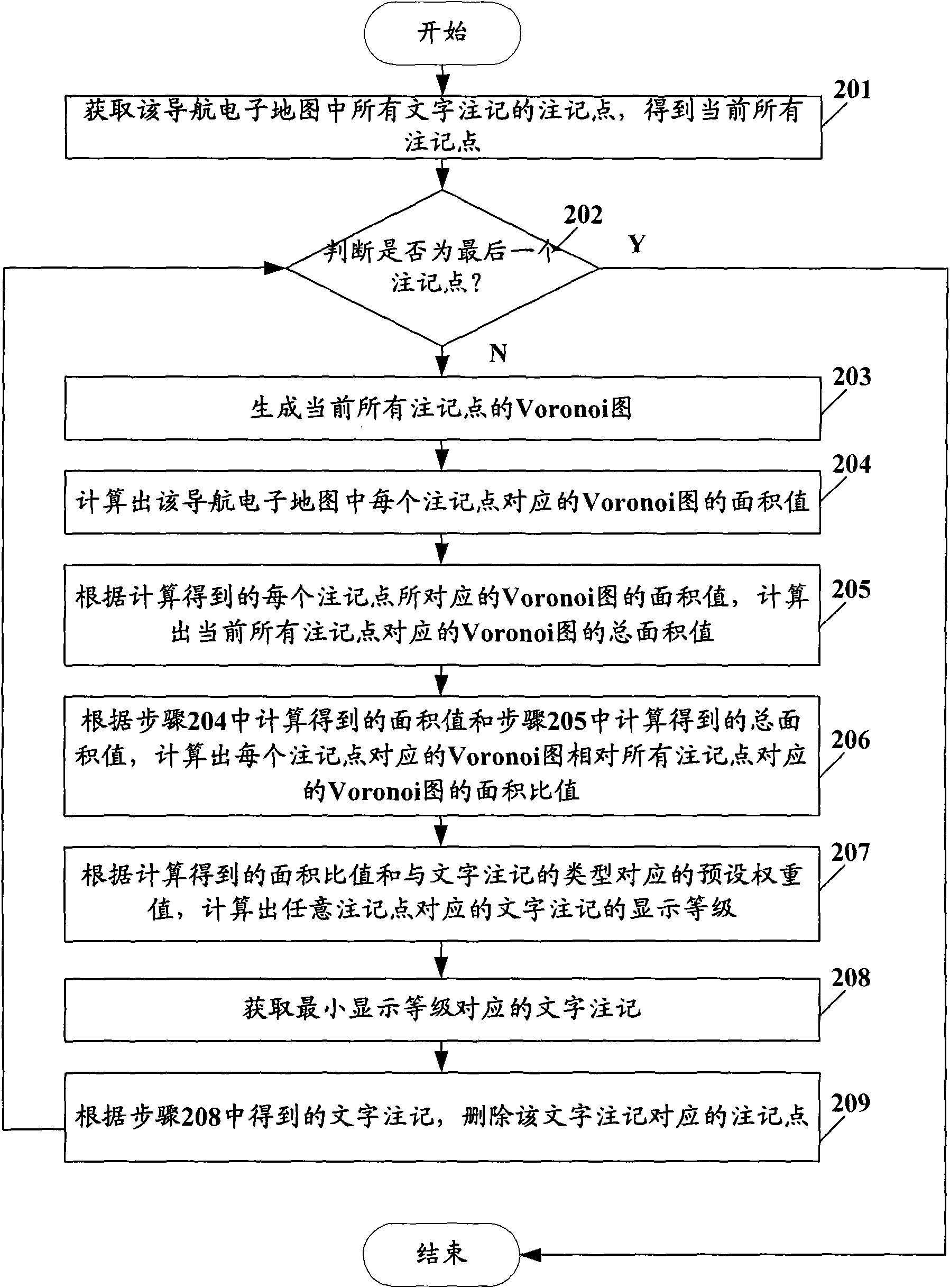
[0075] Such as figure 2 Shown, be the flow chart of the automatic division method two of text annotation display grade in the embodiment of the present invention, concrete steps are as follows:

[0076] Step 201, obtaining all the annotation points of text annotation in the navigation electronic map, and obtaining all the current annotation points;

[0077] In this embodiment, since it is necessary to automatically divide the display level of the text annotation in combination with the spatial distribution relationship of the text annotation, the spatial distribution of the text annotation can be obtained by dividing the Voronoi diagram.

[0078] Step 202, judging whether it is the last note point, if so, then end the process; otherwise, execute step 203;

[0079] Step 203, generating Voronoi diagrams of all current note points;

[0080] Step 204, calculate the area value of the Voronoi diagram corresponding to each annotation point in the electronic navigation map;

[008...


PUM


Abstract

The invention provides a method for automatically dividing the display level of character marks in a navigation electronic map and a device thereof, belonging to the field of a digital drawing technology. The method comprises the following steps: obtaining mark points of all the character marks in the navigation electronic map to obtain all the current mark points; generating the voronoi maps of all the current marking points, and computing the area value of the voronoi maps corresponding to each marking point; according to the computed area value of the voronoi maps corresponding to each marking point, computing the gross area value of the voronoi maps corresponding to all the marking points; according to the area value and the gross area value, computing the area ratio of the voronoi maps corresponding to all the marking points relative to the voronoi maps corresponding to the each marking points; and according to the computed area ratio and the preset weighting value corresponding to the type of the character marking, computing the display level of the character marks corresponding to the each marking point, thereby being capable of automatically ensuring the display level of the character marks in a multi-level scale map.

Description

technical field [0001] The invention belongs to the technical field of digital drawing, and in particular relates to a method and a device for automatically classifying display levels of text notes on a navigation electronic map. Background technique [0002] Navigation electronic map is the carrier of spatial information positioning in mobile information services. Designing and developing an efficient electronic map visualization method is one of the important means to improve the quality of mobile information services, especially the practicality of vehicle navigation. [0003] Cartographic notation is an integral part of the map language, composed of natural language, and plays a complementary role to map symbols. Only when maps have annotations can they be readable and translatable. Map annotations are a very important information transmission tool, and the configuration effect of annotations directly affects the transmission efficiency of geographic information. [000...

Claims


Application Information

Patent Timeline
IPC IPC(8): G01C21/32
Inventor 吴中恒曹晓航曲文启
Owner NAVINFO
Why Eureka
Try Eureka