Method for monitoring third party logistics vehicles by GPS

A logistics vehicle and GPS data technology, applied in logistics, instruments, satellite radio beacon positioning systems, etc., can solve the problems of clear transport vehicle status, inability to achieve logistics information, and cumbersome statistics of logistics data, so as to avoid information lag , Improving communication efficiency and saving management costs

Inactive Publication Date: 2010-04-21
WUHAN YICAI SCI & TECH
0 Cites 15 Cited by

AI-Extracted Technical Summary

Problems solved by technology

[0003] Judging from the current status of the domestic logistics industry, in order to reduce logistics costs, manufacturing companies must choose multiple third-party logistics companies to undertake their logistics outsourcing business. Even if the same logistics company, its vehicles may also be equipped with GPS terminal products from different GPS service providers. In order to ...

Abstract

The invention relates to a method for monitoring operation vehicles of a third party logistics forwarding agent by an enterprise logistics department, in particular to a method for monitoring third party logistics vehicles by GPS. The invention provides the method for monitoring third party logistics vehicles by the GPS, which performs centralized dispatcher, monitoring and commanding on the vehicles provided with GPS terminal products of different GPS operation service providers. By applying the method, the enterprise logistics department can monitor and manage the vehicles provided with different GPS terminals on the same monitoring platform, can monitor information about temperatures, tracks and the like of carriage vehicles in real time, and also can assign tasks to the logistic forwarding agent through a system, while the logistic forwarding agent can automatically receive the tasks, arrange vehicles and give feedback in real time through the system, so the communication efficiency of an enterprise and the logistic forwarding agent is improved, the enterprise can know and monitor the carriage vehicles in time, the management efficiency of the enterprise is improved, and the management cost of the enterprise is saved.

Application Domain

Technology Topic

Image

  • Method for monitoring third party logistics vehicles by GPS
  • Method for monitoring third party logistics vehicles by GPS
  • Method for monitoring third party logistics vehicles by GPS

Examples

  • Experimental program(1)

Example Embodiment

[0029] The embodiments of the present invention will be further described below in conjunction with the drawings.
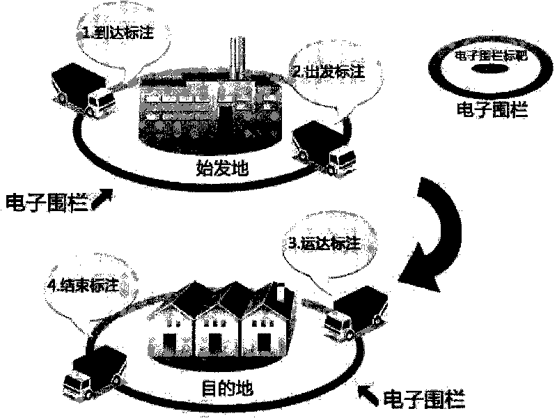
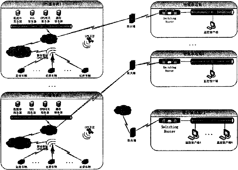
[0030] figure 2 Schematic diagram of the method for GPS monitoring of third-party logistics vehicles; image 3 Diagram of the corporate GPS monitoring architecture (without GPS data forwarding); Figure 4 It is a unified GPS monitoring platform architecture diagram (for GPS data forwarding).
[0031] Such as figure 2 , image 3 , Figure 4 As shown, a method for GPS monitoring of third-party logistics vehicles includes the following steps:
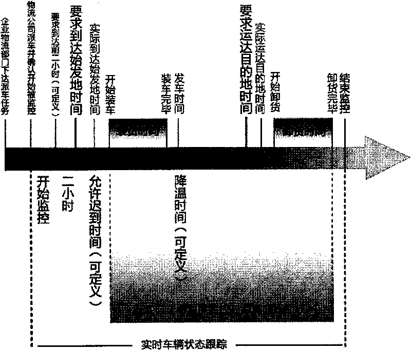
[0032] Step 1: The logistics department of the enterprise issues a dispatch task to the logistics carrier through the GPS monitoring and command software. The information of the dispatch task includes the waybill number, logistics carrier, model, origin, destination, and required arrival specified by the enterprise logistics department. Origin time, required time to reach the destination, temperature requirements of the transported goods;
[0033] Step 2: After the logistics carrier receives the vehicle dispatching task from the logistics department of the enterprise in real time, it selects a vehicle that meets the mission requirements to take charge of this task according to its own vehicle operation. When the logistics carrier confirms that the vehicle is in real-time monitoring, the GPS monitoring command software Send the GPS data forwarding command to the GPS forwarding system on the GPS service provider server of the vehicle in real time;
[0034] Step 3: After the GPS forwarding system of the GPS service provider of the vehicle receives the command to forward GPS data, it will start to forward the GPS data of the vehicle according to the system settings;
[0035] Step 4: After the GPS server of the company's logistics department receives the GPS data forwarded by the GPS forwarding system from the GPS service provider, the company's logistics department can monitor the vehicle's operating status including location and cabin temperature in real time;
[0036] figure 1 Mark the schematic diagram for the electronic fence; figure 1 Shown:
[0037] Step 5: When the carrier vehicle enters the electronic fence of the origin, the system automatically counts the time when the vehicle enters the fence for the first time as the time when the vehicle arrives at the origin;
[0038] Step 6: After the carrier vehicle arrives, the logistics department of the enterprise confirms the start time of loading the vehicle through the mobile smart terminal;
[0039] Step 7: After the vehicle is loaded, the logistics department of the enterprise confirms the time when the vehicle is loaded through the mobile smart terminal;
[0040] Step 8: When the carrier vehicle leaves the "electronic fence of origin", the system automatically counts this time as the departure time of the vehicle; after the departure, the system will continue to monitor the vehicle's information including its running track, vehicle operating status, and cabin temperature. When the temperature of the carriage exceeds the set safety value of the transported goods, and the goods cannot be delivered to the destination on time, the system will give an alarm to prompt the dispatcher to take effective measures;
[0041] Step 9: When the carrier vehicle enters the electronic fence at the destination, the system automatically counts the time of first entering the fence as the time when the vehicle arrives at the destination;
[0042] Step 10: After the vehicle arrives, the logistics department confirms the unloading time through the mobile smart terminal;
[0043] Step 11: After the vehicle is unloaded, the logistics department of the enterprise confirms the unloading time through the mobile smart terminal and sends a message to stop forwarding GPS data to the service provider server to which the GPS of the vehicle belongs in real time, and puts the waybill in the completed state;
[0044] Step 12: After the GPS forwarding system of the GPS service provider of the vehicle receives the message to stop forwarding GPS data, it immediately stops forwarding the GPS data of the vehicle.
[0045] GPS data forwarding format definition and data access interface:
[0046] The invention also specially formulates the data format of GPS data forwarding and the interface of GPS data access. All GPS operators that meet these two standards can forward their GPS data to the company's GPS central server. There are two specific methods, respectively formulating a unified data forwarding format and different data access interfaces.
[0047] method one:
[0048] Through the executable program (interface software) installed on the GPS operator’s computer, use the database type, database server IP address, database name, database access account, database access account password, and data storage table structure provided by the GPS operator to directly access GPS The server used by the operator obtains the required data and actively sends it to the GPS server. This solution requires the GPS operator to open the query authority and query view of the database.
[0049] Operating conditions for interface forwarding software: Operating system: Microsoft Windows XP SP2 and above, Microsoft Windows Server SP2 and above, Microsoft.NET Framework 3.5 SP1. Hardware: Intel P4 2.0G CPU, 512M memory, 60G hard drive and above. Software size: within 10M.
[0050] The information that the interface forwarding software needs to provide is the license plate number, longitude, latitude, direction angle, GPS sending time, speed, temperature, current accumulated mileage, and access control.
[0051] Database types include MS SQL Server, IBM DB2, Sybase, Oracle.
[0052] The view name can be set as "GPS_View_ Vehicle Real-time Information". (This view is provided by GPS service provider)
[0053] This view is mainly to obtain the license plate number, longitude, latitude, direction angle, GPS sending time, cabin temperature, current accumulated mileage, access control and other information.
[0054] View fields (the view should include the following field information)
[0055] Field Name
[0056] Field Name
[0057] Field Name
[0058] Note: There is at least one channel of temperature monitoring data.
[0059] Database read-only account and password
[0060] During installation and debugging, the GPS operator configures the user name and password (read-only account) for accessing the database in the interface forwarding software. The port number that the interface forwarding software needs to open is: 1002. Please open this port in the network firewall.
[0061] Method Two:
[0062] The executable program (interface software) installed on the GPS operator’s computer reads the WebService method provided by the GPS operator to obtain the required data and actively sends it to the GPS central server. This solution requires GPS operators to write XMLWebService interface
[0063] Interface forwarding software operating conditions
[0064] Operating system: Microsoft Windows XP SP2 and above, Microsoft Windows Server SP2 and above, Microsoft.NET Framework 3.5 SP1.
[0065] Hardware: Intel P4 2.0G CPU, 512M memory, 60G hard drive and above.
[0066] Software size: within 10M.
[0067] WebService service provided by GPS operator
[0068] During installation and debugging, the GPS operator configures the WebService address and password in the interface forwarding software.
[0069] Interface function description:
[0070] 1. Obtain vehicle GPS positioning, temperature, access control status information
[0071] Function prototype: GetCarGpsInfo()
[0072] Call constraints: none
[0073] Input parameters:
[0074]
[0075]
[0076] Return parameters:
[0077]
[0078]
[0079] Get the total number of records of vehicle GPS positioning, temperature, and access control status information
[0080] Function prototype: GetCarGpsInfoNumber()
[0081] Call constraints: none
[0082] Input parameters:
[0083] parameter name
[0084] Return parameters:
[0085] parameter name
[0086] The port number that the interface forwarding software needs to open is: 9221. Please open this port in the network firewall.
[0087] Figure 5 The architecture diagram for the first GPS data forwarding; such as Figure 5 As shown, in the key link of step three, after the GPS forwarding system of the GPS service provider of the vehicle receives the command to forward GPS data, it will start forwarding the GPS data of the vehicle according to the system settings.
[0088] We can use another alternative solution, Image 6 For the second type of GPS data forwarding architecture diagram, such as Image 6 As shown, the task of GPS data forwarding can also be completed by the GPS terminal device. After the GPS terminal device receives the message to start forwarding the GPS data, the GPS terminal device sends the collected positioning, cabin temperature and other data to the GPS operator's server and also to the company's GPS central server. This will inevitably increase the flow of data transmitted by GPS terminal equipment, and theoretically double the flow of GPRS (or CDMA) usage. The increase in flow will inevitably increase the operating cost of GPS equipment terminals using mobile networks.
[0089] This method is also quite difficult to deploy and implement in the early stage of enterprise applications. Each time the support for an enterprise is added, each GPS terminal device needs to redeploy the program, and the GPS forwarding software only needs to be deployed to the local area network where the GPS operator’s server is located. On a certain computer, installation, use, upgrade, and maintenance are simple and convenient.
[0090] Any simple modifications, equivalent changes and modifications made to the above embodiments according to the technical essence of the present invention still fall within the protection scope of the present invention.

PUM

no PUM

Description & Claims & Application Information

We can also present the details of the Description, Claims and Application information to help users get a comprehensive understanding of the technical details of the patent, such as background art, summary of invention, brief description of drawings, description of embodiments, and other original content. On the other hand, users can also determine the specific scope of protection of the technology through the list of claims; as well as understand the changes in the life cycle of the technology with the presentation of the patent timeline. Login to view more.

Similar technology patents

WeChat client behavior feedback method and device, and storage medium

ActiveCN107491983AImprove communication efficiencyImprove sales performanceData switching networksSpecial data processing applicationsRandom assignmentPublic account
Owner:PING AN TECH (SHENZHEN) CO LTD

Classification and recommendation of technical efficacy words

  • Improve communication efficiency
  • Improve management efficiency
Why Eureka
Try Eureka