

Automatic and moderate orthographic projection correction method of satellite remote sensing image
A satellite remote sensing image and orthorectification technology, applied to radio wave measurement systems, instruments, etc., can solve problems such as different resolutions, different time phases, and gross errors in control point observations
Active Publication Date: 2010-06-23
CENT FOR EARTH OBSERVATION & DIGITAL EARTH CHINESE ACADEMY OF SCI
View PDF0 Cites 16 Cited by
- Summary
- Abstract
- Description
- Claims
- Application Information
AI Technical Summary
Problems solved by technology
At the same time, due to the defects of the image matching algorithm, and the problems of different resolutions and time phases between the image to be corrected and the reference image, and the difficulty of matching in some areas (snow mountains, deserts, water bodies, forests), etc., the results of a
Method used
View moreImage
Smart ImageViewing Examples

Examples
 PUM
 Abstract
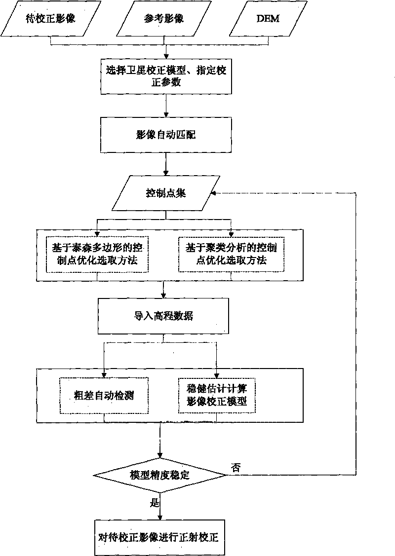
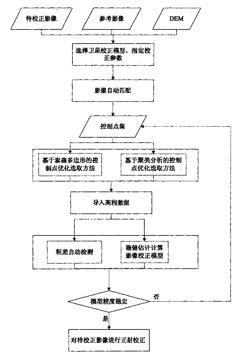
The invention provides an automatic and moderate orthographic projection correction method of a satellite remote sensing image. The method is formed by the organic combination of control point automatic match, control point automatic optimization, control point gross error automatic detection, correction model moderate solving and the like. The method solves the problem that the control points in the control point automatic selection are not uniformly distributed and the problems of detecting control point observed value gross error and improving model solving precision. As the method has the advantages of moderation, precision and high degree of automation, the method is suitable for the production of orthographic projection correction products of the satellite remote sensing image on a large scale.
Description
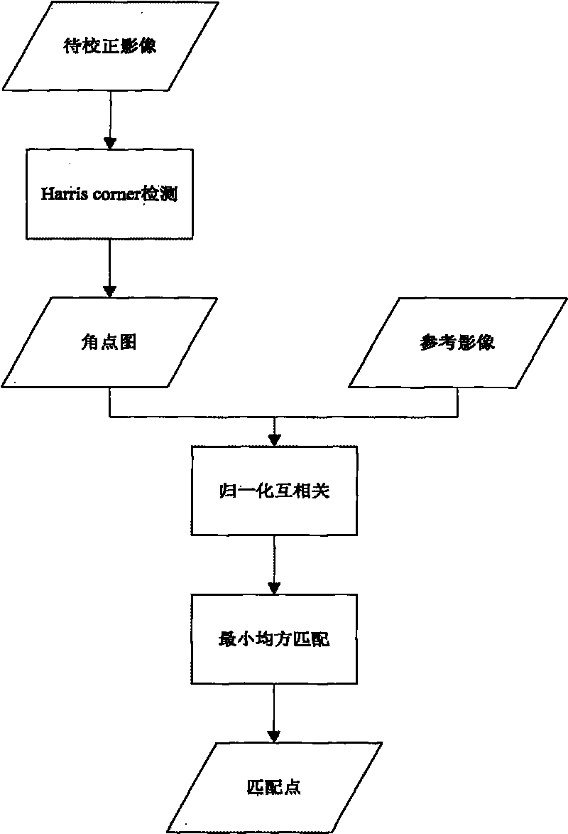
technical field [0001] The invention relates to a satellite remote sensing image geometric correction technology, which is a method for automatically completing the whole process from a satellite remote sensing image preprocessing product to an orthorectification product after specifying required parameter information for correction. The manual selection and editing of control points and gross error observations of control points are the main restrictive factors that could not realize the automatic process of orthorectification of satellite remote sensing images in the past. With this method, the automatic selection of control points, automatic optimization, automatic gross error detection and model robust solution can be realized, and the automation level, correction accuracy and reliability of the satellite remote sensing image orthorectification process can be improved. technical background [0002] The traditional orthorectification process of satellite remote sensing im...
Claims
Login to View More Application Information
Patent Timeline
 IPC IPC(8): G01S7/48
Inventor焦伟利何国金王威程博贾秀鹏项波刘慧婵张晓美陈朋山袁继颖李盈张京涛龙腾飞马应召张兆明孙颖陈立波张鑫刘远秦静刘复生王桂周张思龙王铎
OwnerCENT FOR EARTH OBSERVATION & DIGITAL EARTH CHINESE ACADEMY OF SCI