Method for estimating terrain by polarization interference of data of synthetic aperture radar and software thereof

A technology for interfering synthetic aperture and radar data, which is applied in the field of synthetic aperture radar remote sensing information processing, and can solve problems such as extraction of terrain interferometric phase

Inactive Publication Date: 2010-07-07
INST OF ELECTRONICS CHINESE ACAD OF SCI
View PDF0 Cites 12 Cited by
  • Summary
  • Abstract
  • Description
  • Claims
  • Application Information

AI Technical Summary

Problems solved by technology

The above-mentioned softwares all contain polarization interferometric data processing modules, but they uniformly use coherent optimal or coherent scattering model-based methods to estimate t...

Method used


Image

  • Method for estimating terrain by polarization interference of data of synthetic aperture radar and software thereof
  • Method for estimating terrain by polarization interference of data of synthetic aperture radar and software thereof
  • Method for estimating terrain by polarization interference of data of synthetic aperture radar and software thereof

Examples


Embodiment Construction

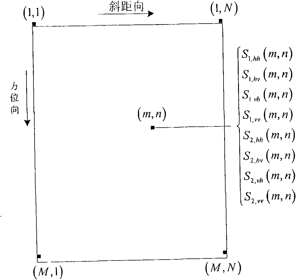
[0137] Firstly, the polarization interferometric data is introduced, which is composed of two sets of fully polarized data such as figure 1 data shown. Full polarization data refers to the four polarities hh, hv, vh, vv obtained by the full polarization antenna system sending horizontal polarization (h) and vertical polarization (v) to send radar signals, and using h, v polarization to receive signals The original echo data in the polarized state, and the complex data S of the hh, hv, vh, and vv polarization states in the same azimuth and slant range positions obtained through imaging processing hh (m, n), S hv (m, n), S vh (m, n), S vv (m, n) constitutes. The polarimetric interferometric SAR data is composed of two sets of fully polarimetric SAR data collected at different times or at different locations at the same time, and the radar signals in each polarization state of each group must be imaged separately. It is also necessary to go through polarization calibration p...


PUM


Abstract

The invention discloses a method for estimating terrain by the polarization interference of the data of a synthetic aperture radar and a software thereof, which relate to synthetic aperture radars. The method comprises the following steps of: (A) filtering polarization interference data; (B) distinguishing different land types by utilizing a polarization classification technique; (C) dividing the data into the land types to form a plurality of simple subblocks; (D) estimating the terrain interference phase of each subblock respectively; (E) processing the terrain interference phase of each subblock in parallel and estimating the terrain of each subblock; and (F) combining the terrain of each subblock and calculating an integral terrain result. The method and the software introduce the polarization classification technique, divide the data into the land types to form a plurality of simple subblocks for processing, adopt different polarization interference methods according to the difference of the land types contained in the subblocks to estimate the terrain interference phases and then calculate the terrain of each subblock. The method not only lowers the difficulty of estimating the terrain of the complicated areas formed by the land types but also enhances the estimation efficiency of the terrain of this class of areas.

Description

technical field [0001] The invention belongs to the technical field of synthetic aperture radar remote sensing information processing, and specifically relates to a method for estimating terrain from polarization interference synthetic aperture radar data and its software. It uses the advantages of polarization classification technology to divide the data of complex areas of land types into several subsections. Block processing reduces the difficulty of terrain interferometric phase estimation and improves the efficiency of terrain estimation; in estimating the terrain interferometric phase of each sub-block, different polarization interferometry methods are used to estimate the terrain interferometric phase for the single scattering center area and the multi-scattering center area ; Due to the differences in the types of multi-scattering center areas between different sub-blocks, different methods are selected to extract the terrain interferometric phase, which is more suitabl...

Claims


Application Information

Patent Timeline
IPC IPC(8): G01S13/90G01S7/41
Inventor 洪文白璐曹芳
Owner INST OF ELECTRONICS CHINESE ACAD OF SCI
Why Eureka
Try Eureka