A Boundary Digitization Method of Cadastral Map Block

A technology of cadastral maps and plots, applied in image data processing, maps/plans/charts, image coding, etc.

Inactive Publication Date: 2011-12-28
BEIJING JIAOTONG UNIV
View PDF0 Cites 1 Cited by
  • Summary
  • Abstract
  • Description
  • Claims
  • Application Information

AI Technical Summary

Problems solved by technology

[0011] The technical problem to be solved by the present invention is to provide a method for digitalizing the boundaries of cadastral map plots to solve the problem of low automation of existing cadastral map digitization methods, man-machine The problem of heavy interactive workload and low efficiency

Method used


Image

  • A Boundary Digitization Method of Cadastral Map Block
  • A Boundary Digitization Method of Cadastral Map Block
  • A Boundary Digitization Method of Cadastral Map Block

Examples


Embodiment Construction

[0056] In order to make the above objects, features and advantages of the present invention more comprehensible, the present invention will be further described in detail below in conjunction with the accompanying drawings and specific embodiments.

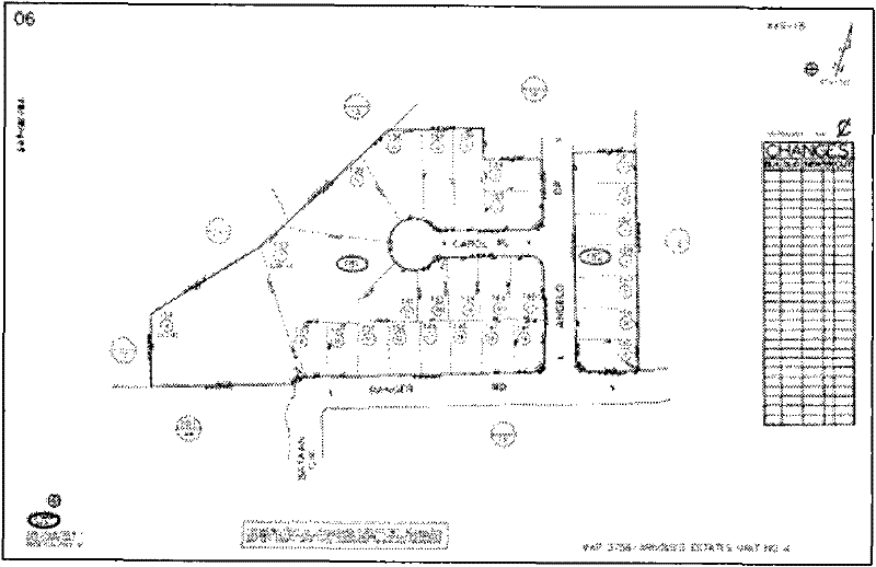
[0057] When digitizing the screen after scanning input, although the scanning vectorization software can be used to perform vector digitization on the scanned raster image, relatively speaking, some work intensity can be reduced and the operation is easier. However, in actual operation, because the cadastral map contains other kinds of graphic content besides the property boundaries or parcel boundaries, such as change records, identifiers and annotations, etc., the scanning vectorization software cannot selectively identify and Therefore, it is not feasible to directly vectorize scanned raster images with scanning vectorization software.

[0058] Object-based image analysis is a new theory that has emerged in recent years. This a...


PUM


Abstract

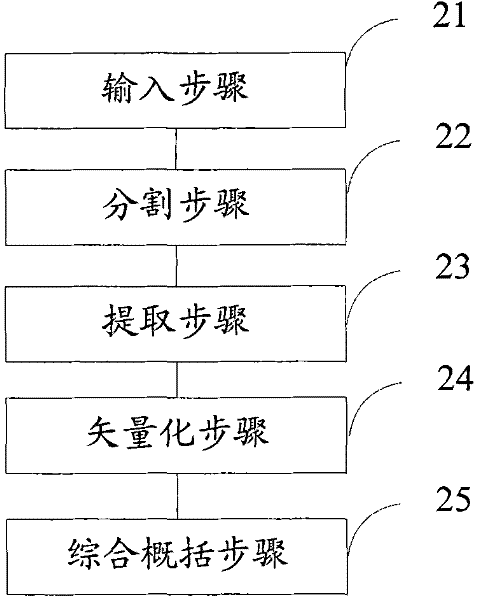
The invention provides a method for digitizing the boundaries of cadastral map plots, comprising: an input step: inputting a scanned raster image of an existing paper cadastral map; a segmentation step: dividing the scanned raster image into a plurality of to-be-classified Image object; extraction step: building knowledge rules, applying object-oriented analysis classification methods, extracting plot objects from the plurality of image objects; vectorization step: vectorizing the extracted plot objects; comprehensive generalization step: The outline of the parcel object is comprehensively summarized, and finally the vectorized cadastral map parcel boundary elements are obtained. The invention is used to solve the problems that the existing cadastral map digitalization method has a low degree of automation, heavy man-machine interaction workload and low efficiency.

Description

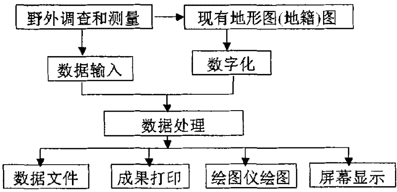
technical field [0001] The invention relates to the technical fields of cadastral surveying, geographical data acquisition and digital surveying and mapping, in particular to a boundary digitization method of a cadastral map block. Background technique [0002] With the continuous acceleration of urban construction, the appearance of the city has undergone tremendous changes, so the existing paper cadastral maps are extremely inconvenient to use and manage. Therefore, the digitization of the original paper maps and the merging of changed cadastral survey data have become inevitable. [0003] refer to figure 1 , which shows the processing flow of a method for digitizing cadastral maps in the prior art, which may mainly include the following parts: [0004] The first part mainly adopts digital input of online hand-held tracking digitizer or screen digitization after scanning input to digitally collect the required cadastral element data (mainly parcels or plot boundaries) on ...

Claims


Application Information

Patent Timeline
Patent Type & Authority Patents(China)
IPC IPC(8): G06T9/00G06K9/00G09B29/00
Inventor 谭衢霖胡吉平
Owner BEIJING JIAOTONG UNIV
Why Eureka
Try Eureka