Method and system for alarming geologic anomaly of location of base station
A geological anomaly and location technology, applied in the field of communication, can solve problems such as inconvenient transportation, damage to communication base stations, and the impact of equipment manufacturers and operators, so as to save costs, ensure normal operation, and strengthen monitoring.
- Summary
- Abstract
- Description
- Claims
- Application Information
AI Technical Summary
Problems solved by technology
Method used
Image
Examples
Embodiment 1
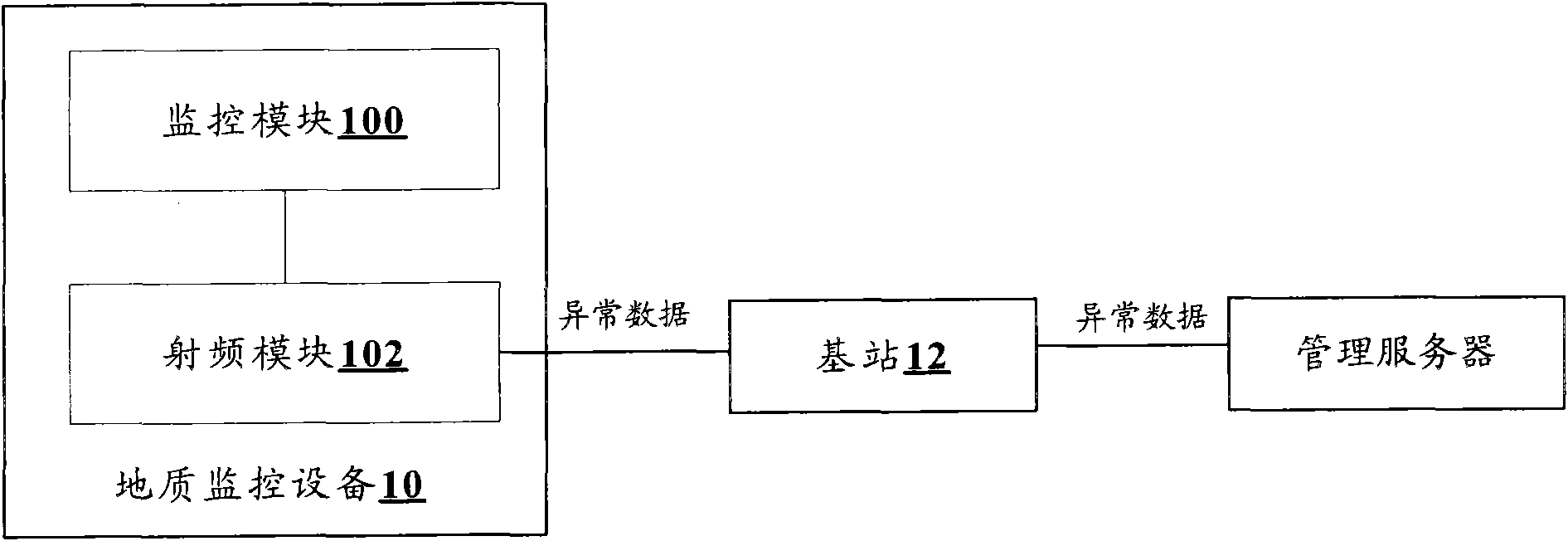
[0018] In this embodiment, a warning system for geological anomalies where the base station is located is provided, figure 1 It is a block diagram of a geological anomaly warning system according to Embodiment 1 of the present invention, such as figure 1 As shown, the system includes: geological monitoring equipment 10 , a base station 12 , and geological data is exchanged between the geological monitoring equipment 10 and the base station 12 . Wherein, the geological monitoring equipment 10 is set at the location of the base station 12 . For example, it is installed on the mountain of the base station 12 .
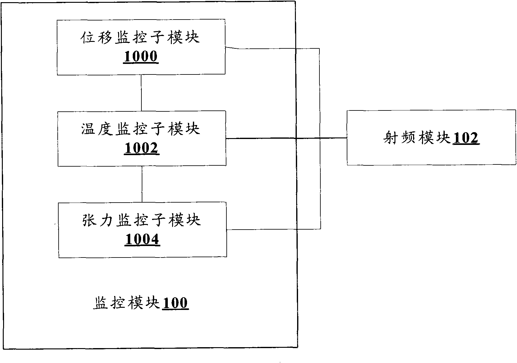
[0019] The geological monitoring device 10 includes: a monitoring module 100 and a radio frequency module 102, wherein the monitoring module 100 is used for real-time monitoring of the geological conditions at the location of the base station 12, and if abnormalities are detected in the geological conditions, the radio frequency module 102 is triggered to send a signal t...
Embodiment 2
[0030] In this embodiment, a preferred geological anomaly warning system is provided, including a geological monitoring device 10 and a base station 12 .
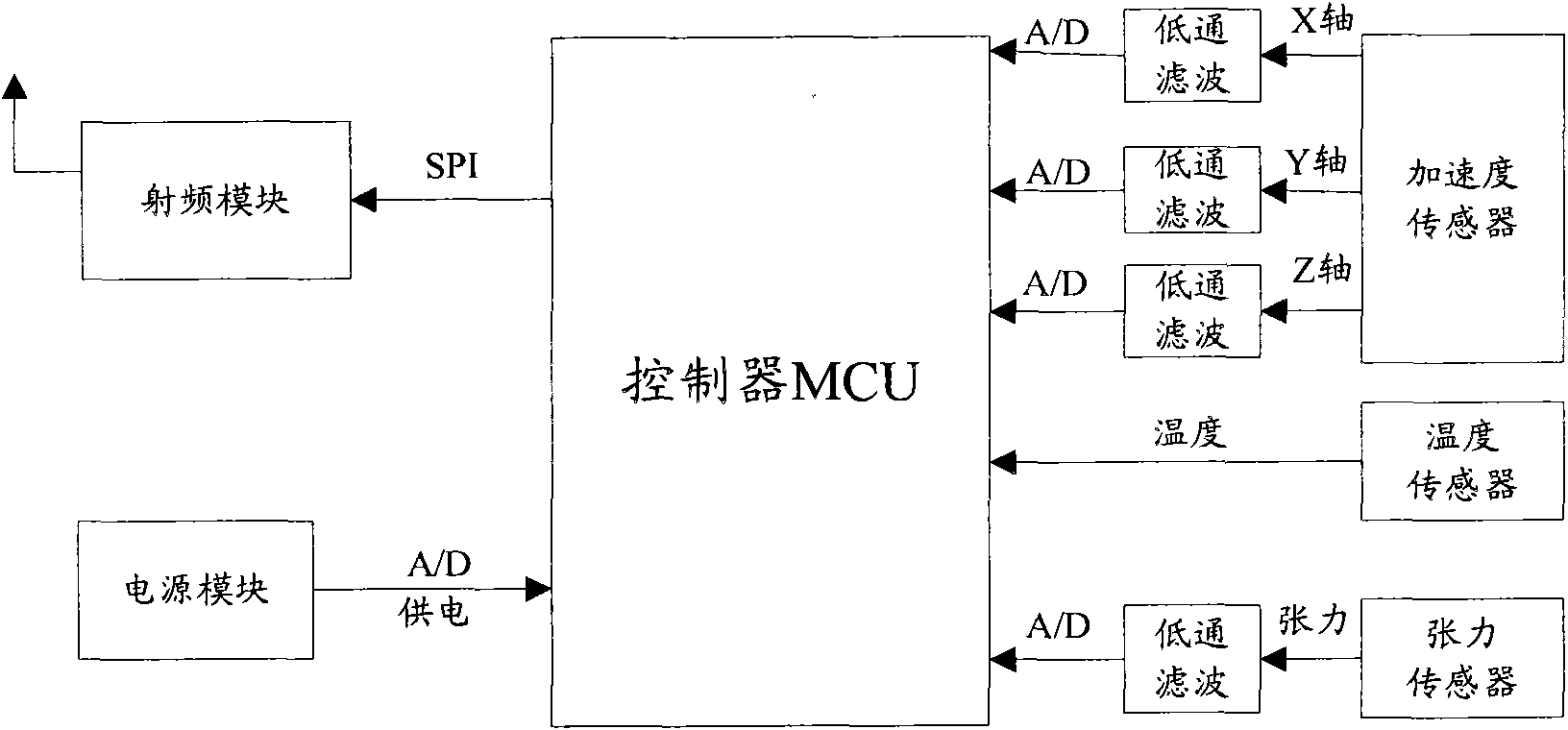
[0031] image 3 It is a hardware deployment diagram of the geological monitoring equipment according to the second embodiment of the present invention. When implementing the geological monitoring equipment of the first embodiment above, the following can be used: image 3 The hardware deployment implementation shown.
[0032] In the implementation process, the displacement monitoring sub-module 1000 in the first embodiment can be realized by setting an acceleration sensor in the geological monitoring equipment, but not limited to, to collect the analog signal of the displacement parameter, and send it to the monitoring module through a low-pass filter and an analog-to-digital converter The controller MCU (can but not limited to use single-chip microcomputer or DSP), the MCU processes the displacement parameter converted in...
Embodiment 3
[0039] In this embodiment, a warning method for geological anomalies in the location of the base station is provided, Figure 5 It is a flow chart of the geological anomaly alarm method according to Embodiment 2 of the present invention, such as Figure 5 As shown, the method includes:
[0040] Step S502, the geological monitoring equipment installed at the location of the base station monitors the geological conditions of the location of the base station in real time;
[0041] Step S504, if the geological condition is monitored to be abnormal, the geological monitoring equipment sends data about the abnormality to the base station;
[0042] Step S506, the base station sends the abnormal data to the remote management server.
[0043] Due to the lack of an effective warning mechanism for geological anomalies in the prior art, the usual solution is to send maintenance personnel to monitor the geological conditions in areas with unstable geological conditions on a regular or lo...
PUM
 Abstract
Description
Claims
Application Information
 - R&D
- Intellectual Property
- Life Sciences
- Materials
- Tech Scout
- Unparalleled Data Quality
- Higher Quality Content
- 60% Fewer Hallucinations
Browse by: Latest US Patents, China's latest patents, Technical Efficacy Thesaurus, Application Domain, Technology Topic, Popular Technical Reports.
© 2025 PatSnap. All rights reserved.Legal|Privacy policy|Modern Slavery Act Transparency Statement|Sitemap|About US| Contact US: help@patsnap.com


