Sensor network-based indoor emergency navigation method

A sensor network and navigation method technology, applied in the field of wireless sensor networks, can solve problems such as inability to accurately quantify congestion, inability to obtain algorithm performance, inability to accurately reflect the impact of congestion evacuation time, etc., to achieve the effect of reducing flooding overhead.

Inactive Publication Date: 2010-11-24
INST OF SOFTWARE - CHINESE ACAD OF SCI
View PDF4 Cites 23 Cited by
  • Summary
  • Abstract
  • Description
  • Claims
  • Application Information

AI Technical Summary

Problems solved by technology

However, these algorithms that consider congestion use the number of people to estimate congestion, cannot accurately quantify congestion, cannot accurately reflect the impact of congestion on evacuation time, and thus cannot obtain the limit of algorithm performance

Method used


Image

  • Sensor network-based indoor emergency navigation method
  • Sensor network-based indoor emergency navigation method
  • Sensor network-based indoor emergency navigation method

Examples


Embodiment Construction

[0045] The present invention will be described in detail through specific embodiments below in conjunction with the accompanying drawings, but it does not constitute a limitation to the present invention.

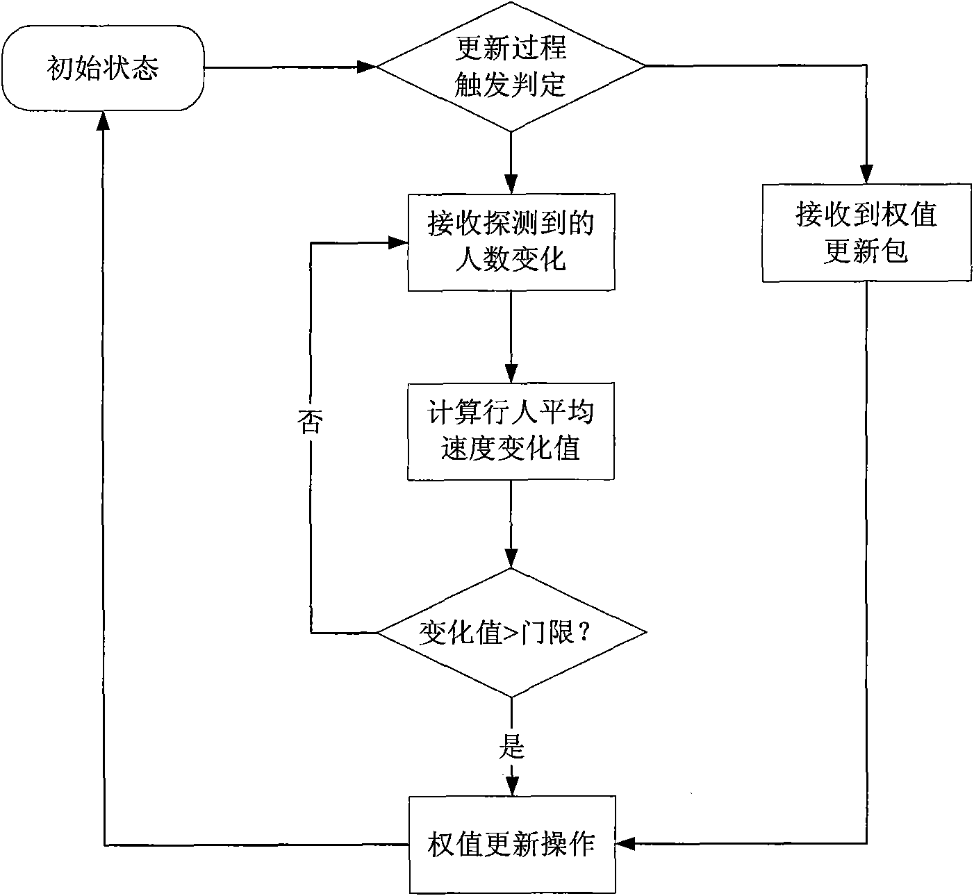
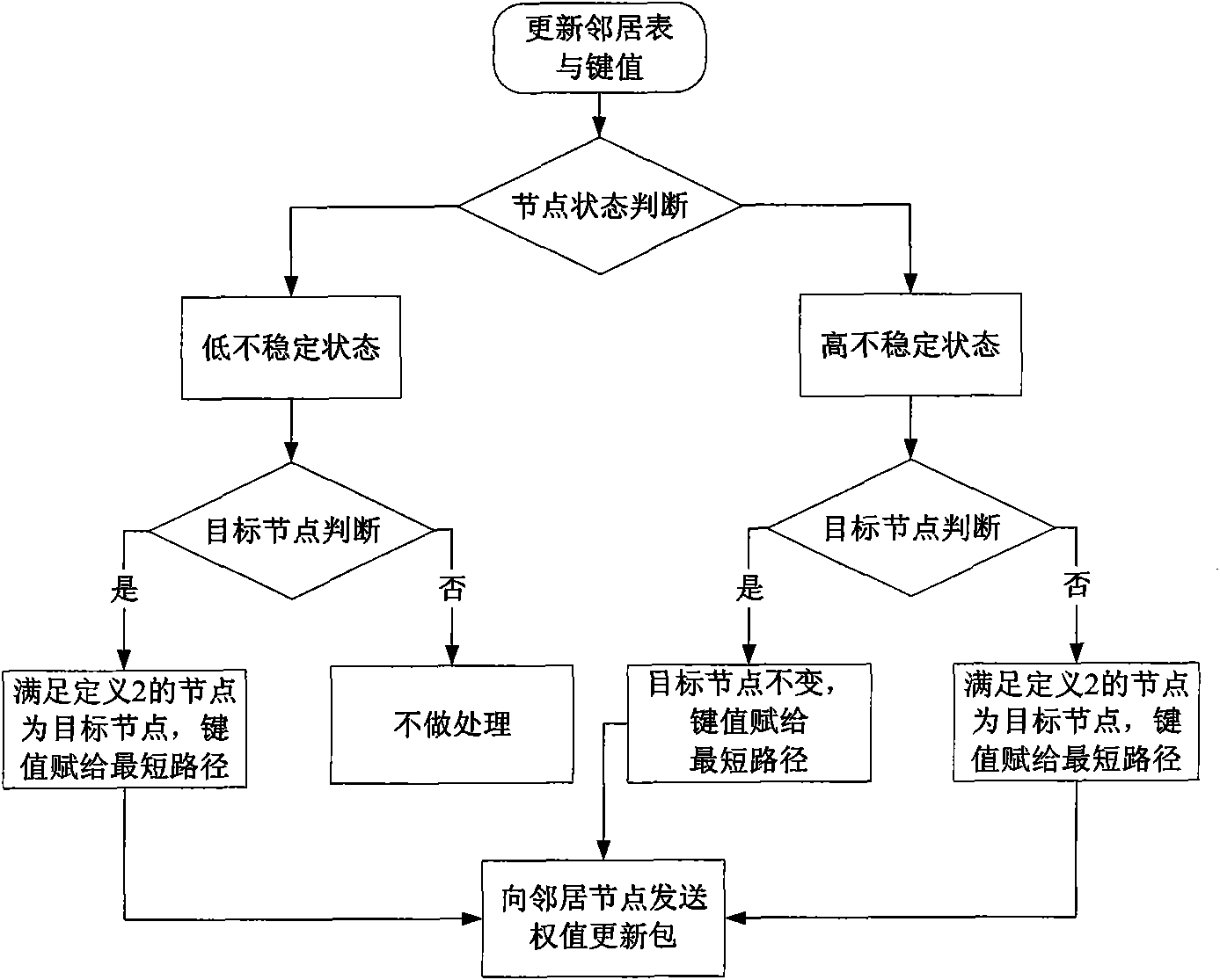
[0046] This embodiment provides an example of an indoor emergency navigation system using the method of the present invention.

[0047] In this embodiment, the nodes deployed in the actual scene are divided into two types. The nodes deployed in the corridor are responsible for detecting changes in the number of people around them, called detection nodes; the nodes deployed at intersections are responsible for guiding indoor personnel to evacuate, called guide nodes node; where the indoor exit position is considered as a special intersection, a guide node needs to be deployed. The detection node is a MicaZ or telosb sensor; a direction display device is connected to the guidance node to instruct the indoor personnel to leave from the nearest corridor, and an LED display can ...


PUM


Abstract

The invention discloses a sensor network-based indoor emergency navigation method. The method comprises the following steps of: arranging a sensor node at an indoor scene, arranging a detection node on a corridor and arranging guide nodes on an intersection and an exit; transmitting detected information of the personnel number to the guide node by using the detection node and calculating the average speed of indoor personnel walking through each corridor and further calculating a weight w by using the guide node; establishing a sensor network diagram G=(V, E, w); if the change value of the average speed of the indoor personnel walking through each corridor is more than a set threshold or a weight update pack transmitted by a neighboring node is received, updating the weight w by using the guide node; and adjusting a target node of the guide node according to the update of the weight w in the diagram G and guiding the indoor personnel to evacuate along an optimal path. Indoor navigation is modeled into a dynamical network diagram, personnel evacuation is described as the movement of network fluid and a shortest path in a network is maintained dynamically so as to realize personnel evacuation with the shortest time.

Description

technical field [0001] The invention belongs to the technical field of wireless sensor networks, relates to an indoor navigation method, in particular to a sensor network-oriented indoor emergency navigation method capable of sensing congestion. Background technique [0002] At present, there are mainly two types of sensor network navigation: centralized and distributed. Among them, the centralized algorithm is mostly used in the situation where the surrounding environment is static or changes slowly, and constructs a navigation route for the mobile robot to cross obstacles. Although these centralized algorithms can accurately complete the navigation task, they are not suitable for situations where the environment changes dynamically. Quickly adjust the navigation route according to the actual situation. The distributed algorithm has high performance in a dynamic environment. The distributed navigation algorithm based on potential energy (Q.Li, M.D.Rosa, and D.Rus, Distribu...

Claims


Application Information

Patent Timeline
Patent Type & Authority Applications(China)
IPC IPC(8): H04W40/02H04W84/18G01C21/00
Inventor 孙利民陈永乐秦伟俊张仲阳
Owner INST OF SOFTWARE - CHINESE ACAD OF SCI
Why Eureka
Try Eureka