Method for realizing target detection and positioning by utilizing GPS satellite navigation signal and device thereof

A satellite navigation signal and target detection technology, which is applied in satellite radio beacon positioning systems, measurement devices, radio wave measurement systems, etc., can solve problems such as insufficient energy of satellite navigation signals, reduce energy constraints, and increase signal processing gain Effect

Inactive Publication Date: 2013-06-05
GUILIN UNIV OF ELECTRONIC TECH
View PDF0 Cites 0 Cited by
  • Summary
  • Abstract
  • Description
  • Claims
  • Application Information

AI Technical Summary

Problems solved by technology

[0003] The technical problem to be solved by the present invention is to provide a method and device for realizing target detection and positioning using GPS satellite navigation signals based on the insufficient energy of existing satellite navigation signals for target detection

Method used


Image

  • Method for realizing target detection and positioning by utilizing GPS satellite navigation signal and device thereof
  • Method for realizing target detection and positioning by utilizing GPS satellite navigation signal and device thereof
  • Method for realizing target detection and positioning by utilizing GPS satellite navigation signal and device thereof

Examples


Embodiment Construction

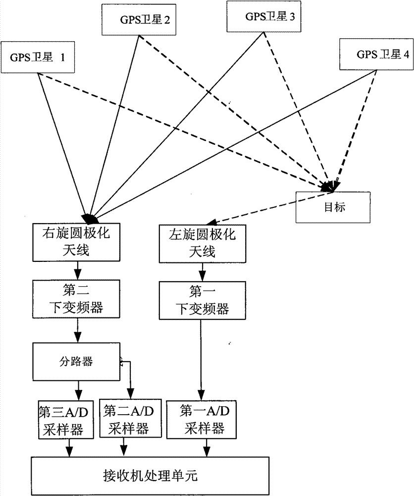
[0025] figure 1 A kind of device that utilizes GPS satellite navigation signal of the present invention to realize target detection and location, mainly by the antenna unit of 2 sets of opposite polarized directions, 2 down-converters, 1 splitter, 3 A / D samplers, and a receiver processing unit; the output end of the second antenna unit receiving the direct waves of 4 or more visible GPS satellites is connected to the splitter through the second down converter; receiving 4 or more The output end of the first antenna unit of the reflected wave of the visible GPS satellite is connected with the first down converter; the output end of the splitter is respectively connected with the third A / D sampler and the second A / D sampler; the first down converter The output end of the frequency converter is connected to the first A / D sampler; the output ends of the first A / D sampler, the second A / D sampler and the third A / D sampler are all connected to the receiver processing unit. The above...


PUM


Abstract

The invention discloses a method for realizing target detection and positioning by utilizing GPS satellite navigation signal and a device thereof. Two antennae in opposite polarization directions are adopted to respectively receive GPS direct wave and reflected wave, the traditional GPS C / A code positioning method is adopted on the direct wave, and receiver position and satellite ephemeris are obtained. Corresponding processing is carried out on P code of GPS reflected signal and P code of direct signal, thus obtaining distance difference between the reflected wave and the direct wave. When four or more than four visual satellites are existed, receiver position and satellite ephemeris which are measured by utilizing C / A code and distance difference measured by utilizing P code are utilized to form a hyperboloid equation, and real time positioning on target is realized. The invention utilizes C / A code P code aid method to improve signal processing gain, energy restriction of GPS can be solved or reduced, cost is low, hidden nature is more obvious, and detection and positioning tracking on hidden and low-angle target in important protected airspace are realized.

Description

technical field [0001] The invention relates to the technical field of satellite navigation, in particular to a method and device for realizing target detection and positioning by utilizing GPS satellite navigation signals. Background technique [0002] GPS is widely used for its high precision, no blind spots, all-weather continuous and rapid positioning, timing and attitude determination. Since multi-path signals are the main error source of high-precision GPS positioning, the GPS reflection signal is used as an interference signal in the measurement must be suppressed. However, the actual GPS reflection signal can also be used. The GPS reflection signal not only has similarity and compatibility with the traditional target detection signal, but more importantly, the GPS signal can fundamentally solve the problem of time and phase synchronization, and when there are 4 Real-time positioning can be achieved when there are visible satellites or more. Among them, the use of G...

Claims


Application Information

Patent Timeline
Patent Type & Authority Patents(China)
IPC IPC(8): G01S19/42
Inventor 孙希延纪元法莫建文孙希刚耿建平张顺岚
Owner GUILIN UNIV OF ELECTRONIC TECH
Why Eureka
Try Eureka