Electronic map information grid processing and querying method facilitating quick query

A technology of electronic map and query method, applied in the direction of electronic digital data processing, special data processing applications, instruments, etc., can solve the problems of fast and real-time geographic processing, and achieve the effect of fast search

Inactive Publication Date: 2011-03-30
CHONGQING UNIV +1
View PDF5 Cites 25 Cited by
  • Summary
  • Abstract
  • Description
  • Claims
  • Application Information

AI Technical Summary

Problems solved by technology

[0003] In view of the above problems, the present invention provides an electronic map information grid processing and query method that is convenient for fast query, so as to solve the application bottleneck problem that requires fast and real-time geographic processing

Method used


Image

  • Electronic map information grid processing and querying method facilitating quick query
  • Electronic map information grid processing and querying method facilitating quick query
  • Electronic map information grid processing and querying method facilitating quick query

Examples


Embodiment Construction

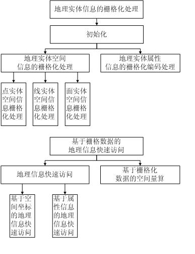
[0031] Rasterization processing of geographic entity information in step 3) of the present invention

[0032] (1) Rasterization processing of spatial information of point entities

[0033] Set the coordinates of the point entity as (X A , Y A ), according to the raster resolution (X R , Y R ), the point entity A at the grid position (m, n) is:

[0034] (Form I)

[0035] (I) where For rounding operation, (X O , Y O ) is the geographic coordinate corresponding to the starting grid geography.

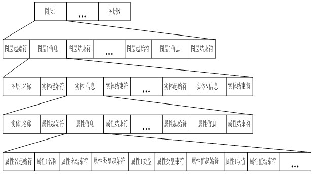
[0036] On this basis, the attribute information of the point entity is coded and converted according to the method given in (4) below in this step, that is, the grid coordinates are converted into two-dimensional array subscripts, and then the converted attribute information is stored in the location of In the two-dimensional array cell corresponding to the grid of (m, n).

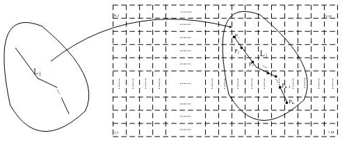
[0037] (2) Rasterization processing of spatial information of line enti...


PUM


Abstract

Aiming at the problems that the conventional two-dimensional electronic map query processing has high time cost and is unfavorable for quickly processing geographic information, the invention provides a grid-based two-dimensional electronic map information data quick processing and querying method. The spacial information of a geographic entity in an electronic map corresponds to subscripts of a two-dimensional array unit one to one according to grid positions; meanwhile, the attribute information of the geographic entity is coded and stored in a corresponding two-dimensional array unit to realize the grid processing of the information data (the spacial information and the attribute information) of the geographic entity in the two-dimensional electronic map. On the basis of the grid processing and aiming at the requirement of query according to the spacial information condition and the attribute information condition, the invention respectively provides a query method from a geographic spacial coordinate to a grid position to a subscript of a two-dimensional array unit, and an attribute content-array subscript index-based query method so as to realize the quick query of the geographic information.

Description

technical field [0001] The invention relates to a fast access processing technology of electronic map information, in particular to a rasterized processing and query method of electronic map information that is convenient for fast query. Background technique [0002] With the development of social economy and information technology, people's demand for spatial information as one of the spatio-temporal elements describing human activities is also increasing. One of the bottlenecks. Especially in the aspects of urban emergency and disaster management, it is necessary to complete the access and processing of geographic information in a very short time. At present, because the data structure of commonly used geographic data is vector data, the continuous, rapid and real-time processing of commonly used geographic data, especially the access processing of geographic information whose boundary range type is known and the range position changes continuously, is not satisfactory. ...

Claims


Application Information

Patent Timeline
Patent Type & Authority Applications(China)
IPC IPC(8): G06F17/30
Inventor 郭茂耘柴毅何京江魏善碧魏洪波孙健王强屈剑锋吴伟
Owner CHONGQING UNIV
Why Eureka
Try Eureka