Adaptive spatial interpolation method

A space interpolation and self-adaptive technology, applied in the direction of image data processing, instrumentation, 2D image generation, etc., to achieve the effect of ensuring accuracy and reliability

Inactive Publication Date: 2011-05-25
北京农产品质量检测与农田环境监测技术研究中心
View PDF2 Cites 3 Cited by
  • Summary
  • Abstract
  • Description
  • Claims
  • Application Information

AI Technical Summary

Problems solved by technology

[0006] The technical problem to be solved by the present invention is: how to overcome the deficiencies in the prior art, and provide an adaptive spatial interpolation method that can ensure the accuracy of

Method used


Image

  • Adaptive spatial interpolation method
  • Adaptive spatial interpolation method
  • Adaptive spatial interpolation method

Examples


Embodiment Construction

[0053] In order to make the purpose, content, and advantages of the present invention clearer, the specific implementation manners of the present invention will be further described in detail below in conjunction with the accompanying drawings and embodiments.

[0054] First, in order to eliminate ambiguity, the content involved in the following content is explained as follows:

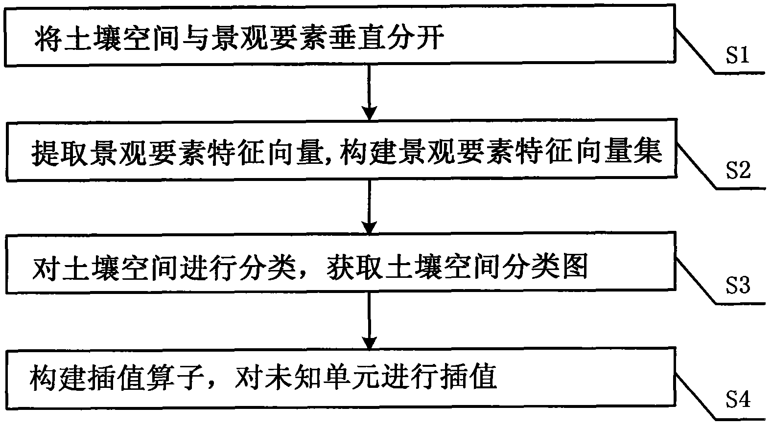
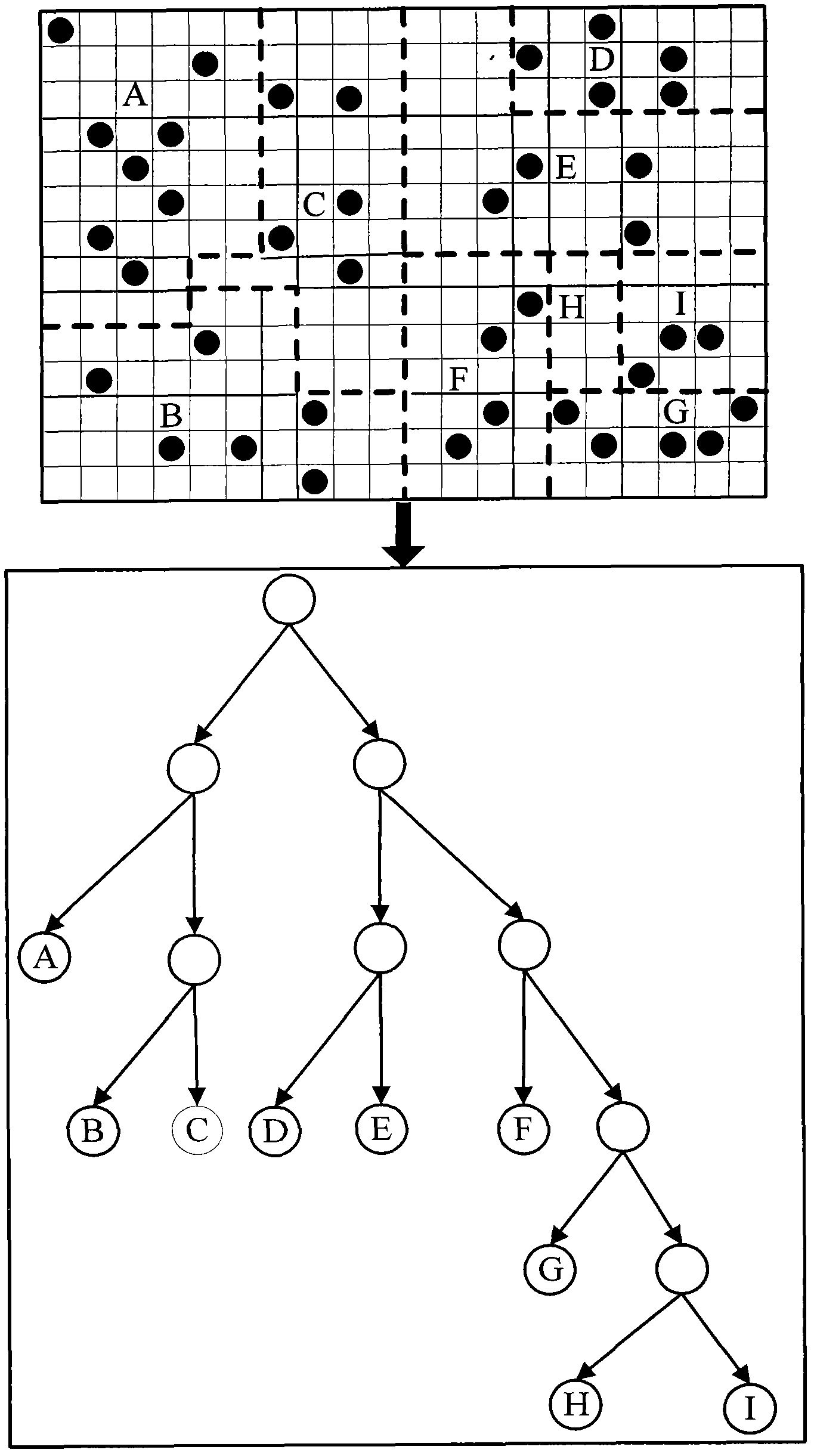
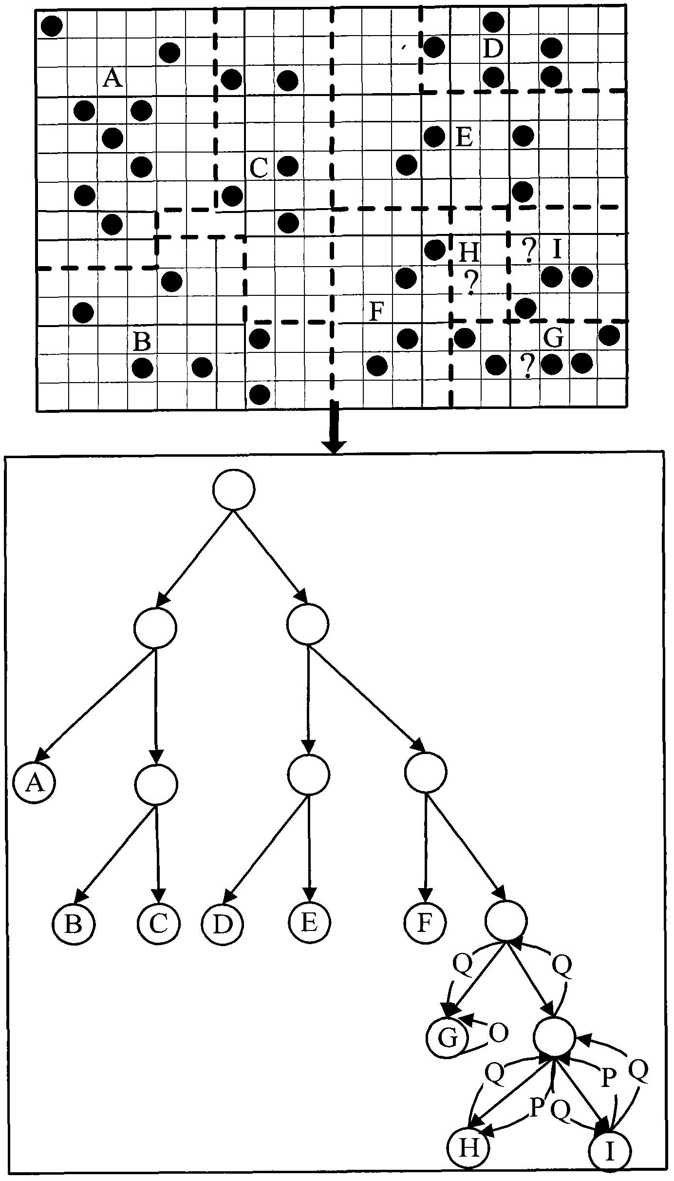
[0055] The interpolation unit refers to the basic grid unit that constitutes the soil space class, see figure 2 shown;

[0056] Unknown unit refers to the interpolation unit that does not contain monitoring sample points;

[0057] The interpolation operator only performs interpolation calculation for the unknown unit, and the observed value of the interpolation unit is characterized by the monitoring sample point data contained in the interpolation unit during the interpolation process.

[0058] Below, such as figure 1 As shown, the adaptive spatial interpolation method involved in the technical so...


PUM


Abstract

The invention relates to an adaptive spatial interpolation method, which belongs to the technical field of soil digital mapping. In order to overcome the difficulty of unreliability of spatial interpolation of soil property in the digital soil mapping, the invention provides an interpolation method, which comprises the following steps of: in a geographic space, separating a soil space from a landscape element in a vertical direction, wherein the bottom layer is a soil layer and the upper layer is a landscape element characteristic vector layer; gridding the soil layer according to a certain scale, extracting landscape element characteristic vectors corresponding to any grid units in the grid soil layer, and constructing a landscape element characteristic vector set; classifying the soil space according to the landscape element characteristic vector set so as to obtain a soil space classification map; and establishing an interpolation operator on the basis of the soil space classification map, and interpolating any unknown units in the soil space according to the interpolation operator. By using the technical scheme, the accuracy and the reliability of the space interpolation of the soil property content under a complicated landscape environment are improved and ensured.

Description

technical field [0001] The invention relates to the technical field of soil digital mapping, in particular to an adaptive spatial interpolation method suitable for spatial interpolation of attribute information of research objects such as soil, hydrology, and meteorology under medium / large-scale complex landscape conditions and digital map production. Background technique [0002] Affected by manpower and material resources, the sampling observation of regional soil attribute information is always limited. How to accurately describe the area source distribution information of regional soil attribute information through limited and discrete observation sample point data has always been a difficult point of interest to people. question. At present, the main methods to describe the spatial distribution information of soil properties are geostatistical methods and soil-landscape models. [0003] The premise of geostatistical methods is that there is spatial autocorrelation in s...

Claims


Application Information

Patent Timeline
IPC IPC(8): G06T11/00
Inventor 王纪华尤冬梅马智宏潘立刚韩平陆安祥
Owner 北京农产品质量检测与农田环境监测技术研究中心
Why Eureka
Try Eureka