Map building method and map system

A technology for establishing methods and maps, which is applied in special data processing applications, instruments, electrical digital data processing, etc., can solve problems such as slowing down of database access speed and affecting user experience, and achieve reduction of storage space, improvement of usage rate, and acceleration of positioning speed effect

Inactive Publication Date: 2011-06-22
CHINA MOBILE COMM GRP CO LTD
View PDF0 Cites 8 Cited by
  • Summary
  • Abstract
  • Description
  • Claims
  • Application Information

AI Technical Summary

Problems solved by technology

When the amount of data stored in the map database is large, it will ine

Method used


Image

  • Map building method and map system
  • Map building method and map system
  • Map building method and map system

Examples


Embodiment Construction

[0021] The present invention will be further described in detail below in conjunction with the accompanying drawings and specific embodiments.

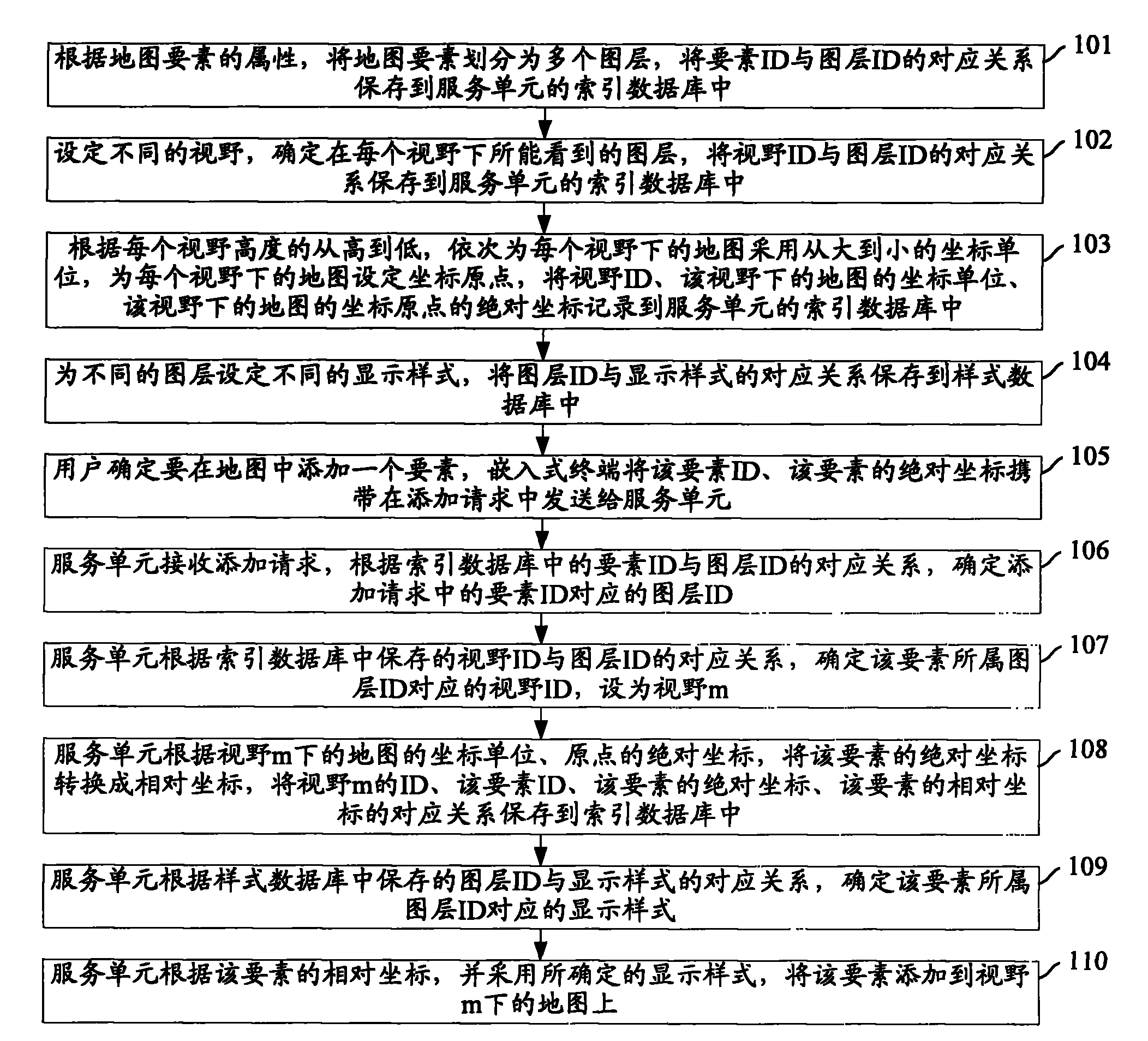
[0022] figure 1 The flow chart of the map creation method provided by the embodiment of the present invention, such as figure 1 As shown, the specific steps are as follows:

[0023] Step 101: Divide the map elements into multiple layers according to the attributes of the map elements, and store the correspondence between element IDs and layer IDs in the index database of the service unit.

[0024] A layer can be: a base terrain layer, a city management part layer, and so on. Among them, the basic terrain layer can be further divided into: road layer, green map layer, building layer, etc., and the city management component layer can be further divided into: road surface layer, manhole cover layer, etc. Each layer contains multiple elements. For example, the manhole cover layer contains all manhole covers, and each manhole cover is a...


PUM


Abstract

The invention discloses a map building method and a map system. The method comprises the following steps of: dividing map elements into multiple map layers according to the attributes of the map elements; setting different visual fields, and determining the map layers seen in the different visual fields; sequentially adopting coordinate units from big to small according to the high-to-low visual field heights; when an element is added in the map, determining the map layer of the element, determining the visual field of the map layer, converting the absolute coordinate of the element into the relative coordinate on the map in the visual field according to the original point and the coordinate unit of the map in the visual field, and storing the corresponding relationship among the visual field identification, the absolute coordinate of the element and the relative coordinate of the element; and adding the element to the map in the visual field according to the relative coordinate of the element. The method reduces the storage space occupied by the map data, and improves the utilization rate of the map to a great extent.

Description

technical field [0001] The invention relates to the technical field of digital maps, in particular to a map establishment method and a map system. Background technique [0002] Urban management components refer to various facilities in urban management public areas, including municipal public facilities, road traffic facilities, city appearance and sanitation facilities, landscaping, and other categories such as: sewer covers, referred to as components. Urban management incidents refer to the general term for events and behaviors that affect or destroy the urban environment and environmental order caused by human or natural factors, and need to be dealt with by the urban management department and restored to normal. The new model of digital city management refers to the combination of the 10,000-meter unit grid management method and the urban component and event management method, and the application and integration of multiple digital city technologies to achieve a digital ...

Claims


Application Information

Patent Timeline
IPC IPC(8): G06F17/30
Inventor 李晟刘越范晓晖王洪深何英杰
Owner CHINA MOBILE COMM GRP CO LTD
Why Eureka
Try Eureka