Method for improving altitude measurement precision of linear array static infrared horizon sensor

A technology of infrared horizon and measurement accuracy, which can be applied to integrated navigators and other directions, and can solve problems such as instantaneous field of view, measurement accuracy, and attitude measurement range constraints

Inactive Publication Date: 2011-09-07
SHANGHAI INST OF TECHNICAL PHYSICS - CHINESE ACAD OF SCI
View PDF3 Cites 27 Cited by
  • Summary
  • Abstract
  • Description
  • Claims
  • Application Information

AI Technical Summary

Problems solved by technology

[0018] The purpose of the present invention is to improve the attitude measurement accuracy of the horizon without changing the optical-mechanical structure and electronic hardware of the existing line array static infrared horizon, and to solve the mutual constraints between the instantaneous field of view of the detection element, the measurement accuracy, and the attitude measurement range The problem

Method used


Image

  • Method for improving altitude measurement precision of linear array static infrared horizon sensor
  • Method for improving altitude measurement precision of linear array static infrared horizon sensor
  • Method for improving altitude measurement precision of linear array static infrared horizon sensor

Examples


Embodiment Construction

[0077] The method described in the invention is verified by a certain type of satellite line array static infrared horizon, and combined with an earth simulator for error evaluation.

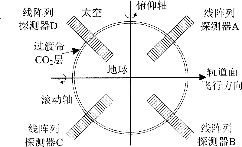
[0078] The orbital height of the satellite is about 800km, and the attitude measurement range is ±11°. Four 32-element line array thermopile detectors are selected, and the field of view angle of a single detector element can be calculated as 0.6875°, and the angle of the transition zone to the satellite is 0.7°, corresponding to one detector element Width, α / θ≈1. The horizon adopts the existing boundary position detection method, the output boundary position value is an integer, and the measurement accuracy of the boundary position is ±1 yuan.

[0079] Place the horizon on the earth simulator, let the "boundary" of the earth simulator scan in steps of 1 / 20 yuan in the field of view of the horizon, and collect detection metadata. V' according to the present invention high and V' low The value...


PUM


Abstract

The invention discloses a method for improving precision of a spaceborne linear array static infrared horizon sensor. The method comprises the following steps of initial judgment of an earth-space boundary position, selection of a reference signal, normalization of a detector signal, selection of a boundary judgment element, high-precision detection of the earth-space boundary position, and high-precision altitude calculation. Combined with the characteristics of the horizon sensor and based on the characteristic that a detection element signal corresponding to a transition zone changes regularly with the movement of the earth-space boundary in a field of view of the detector, the invention creatively provides a method for locating the earth-space boundary position highly precisely by the boundary judgment element to improve the measurement precision of the horizon sensor. By the invention, the problem that an instantaneous field of view angle of a detection element, the measurement precision and the altitude measurement range are restricted mutually in the design of the conventional horizon sensor is solved. The method has the characteristics of small calculation quantity and high generality, and is easy to implement, so the method can be applied to spaceborne linear array static infrared horizon sensors with different orbit heights.

Description

technical field [0001] The invention relates to a spaceborne infrared horizon, in particular to a method for improving the attitude measurement accuracy of a line array static infrared horizon. Background technique [0002] The infrared horizon (or called the infrared earth sensor, referred to as the horizon) is based on the principle of being sensitive to the infrared radiation of the attitude reference source, the satellite attitude optical sensitivity that realizes the measurement of the satellite's rolling and pitching attitude information relative to the local vertical line in orbit. device. According to whether the horizon includes a mechanical scanning mechanism, the horizon can be divided into two types: scanning and static; scanning horizon can be divided into two types: conical scanning and swing scanning; static horizon is divided into two types: line array and area array. . [0003] Since the United States GoodRich company developed the world's first infrared s...

Claims


Application Information

Patent Timeline
Patent Type & Authority Applications(China)
IPC IPC(8): G01C21/24
Inventor 谢宗宝崔维鑫朱进兴张涛韩开亮
Owner SHANGHAI INST OF TECHNICAL PHYSICS - CHINESE ACAD OF SCI
Why Eureka
Try Eureka