Running information based road condition management method and system

A driving information and management method technology, applied in the field of road condition management of generating, automatically collecting, reporting and viewing vehicle road condition information, can solve the problems of inconvenient operation, unintuitiveness, inability to perform comprehensive error correction, etc., to achieve convenient acquisition and data volume. small effect

Active Publication Date: 2011-09-14
ZHEJIANG UNIV
5 Cites 28 Cited by

AI-Extracted Technical Summary

Problems solved by technology

[0002] With the continuous development of automobile transportation, various vehicle road condition monitoring systems are becoming more and more common and extensive. The existing road condition systems can monitor traffic flow and road busy conditions to help traffic management and scheduling, but the existing road condition detection systems The obtained data is relatively single, often only contains GPS location information, which is very unintuitive, and multiple information is also independent of each other, unable to perform comprehensive error correction, analysis and situational reasoning, and automatically report hypermedia information; at t...

Method used

Geographic location acquisition module 111 can adopt GPS or Beidou system, for GPS, because the data that GPS receives can not be directly used for other modules, will analyze data, the data that GPS receives is based on WGS.84 coordinates system, and the plane coordinate system used by some map data in my country is based on the Beijing 54 coordinate system, so for the electronic map based on the Beijing 54 coordinate system, it is necessary to convert the coordinate system of the received GPS data first. The data output by the preprocessing unit 12 is organized in XML format for easy reading.
In the electronic map, the points of interest in an area are defined by names, such as scenic spots, shops, hotels, etc., by using the points of interest as the semantic map position of the current geographic location, the semantic map can be quickly realized Location targeting. Since different POI definitions have different degrees of popularity, when searching for the nearest POI at the current geographic location on the electronic map, the two parameters of the POI's popularity and the distance to the POI are considered to select a nearby POI with high popularity as the Semantic map location.
Road condition information output unit 23 also comprises the voice broadcast unit 231 that is used for voice output road condition information, and voice broadcast unit 231 outputs road condition information according to the evaluation result of road condition importance evaluation unit 22, and voice broadcast unit 231 can automatically filter the same time and positional repeating type events for reliable voice playback. The voice broadcast unit 231 is implemented based on the Speech SDK, and can output the result in text form obtained by the evaluation of the road condition importance evaluation unit 22 in voice output for voice broadcast.
When road condition management center obtains the semantic map position of vehicle according to the geographical location received, obtain the current geographic location type of vehicle according to geographic location, if current geographic location is expressway, then search the section expressway on electronic map The nearest exit or gas station location, the nearest exit location is used as the semantic map location of the current geographic location; otherwise, the point of interest closest to the current geographic location is found on the electronic map, and the point of interest is used as the semantic map of the current geographic location the location on the map. Obtain the semantic map position according to the geographic location type, and obtain the traffic jam ...

Abstract

The invention discloses a running information based road condition management method and system. The method comprises the following steps of: (1) acquiring geographic position, speed, acceleration and distance with a front vehicle of a vehicle which encounters a road condition; (2) packaging the acquired geographic position, speed, acceleration and distance with the front vehicle and transmittingto a road condition management center; and (3) acquiring a semantic map position of the vehicle by the road condition management center according to the received geographic position, and acquiring a traffic jam condition of the current semantic map position according to the received speed, acceleration and distance with the front vehicle. The system comprises a vehicle road condition reporting unit (1) arranged on the vehicle and a master control unit (2) used for road condition management. The method and the system have the advantages of capability of conveniently acquiring the traffic jam condition of the semantic map position, small data quantity, accuracy and reliability.

Application Domain

Technology Topic

Image

  • Running information based road condition management method and system
  • Running information based road condition management method and system
  • Running information based road condition management method and system

Examples

  • Experimental program(1)

Example Embodiment

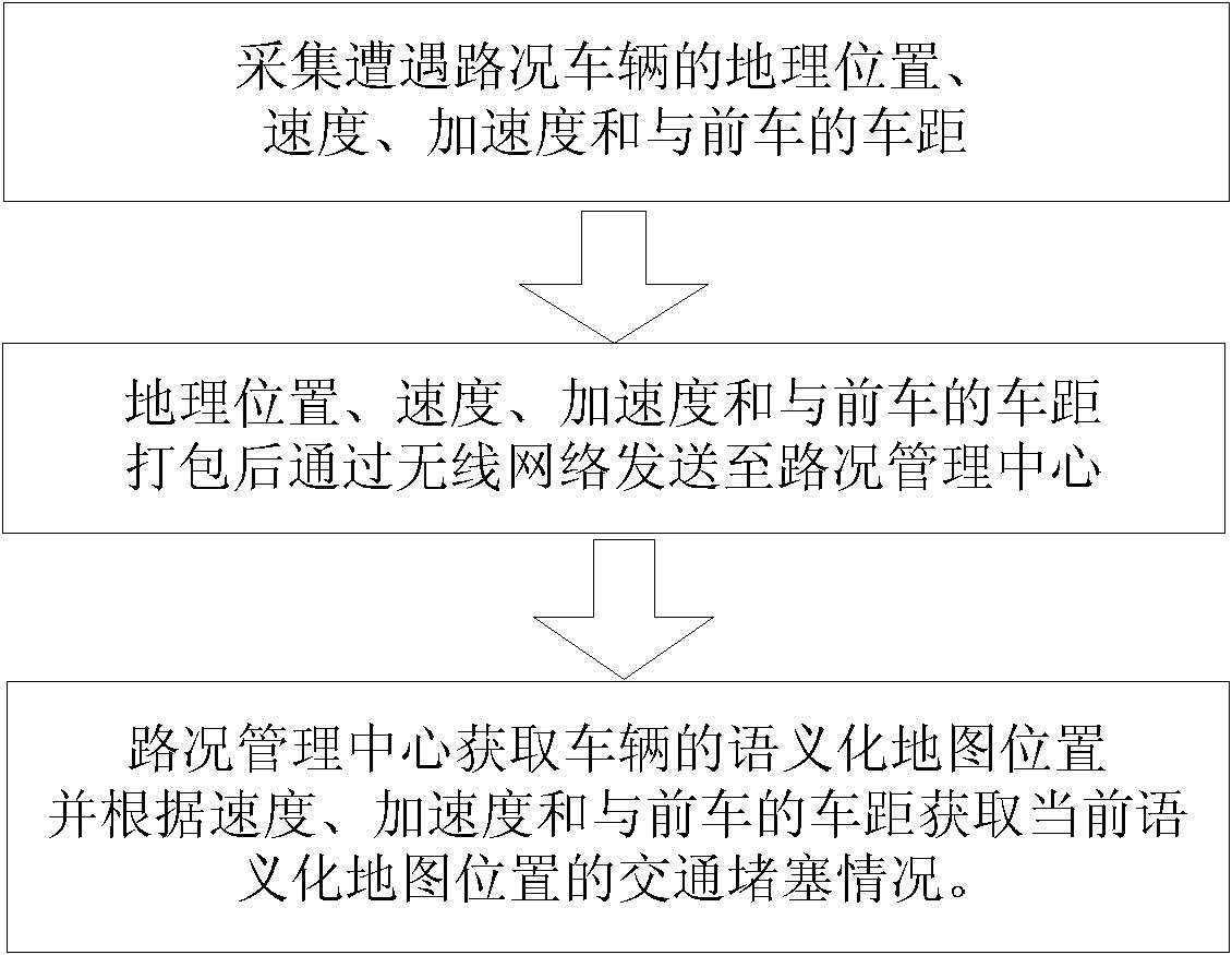
[0025] like figure 1 As shown, the implementation steps of the road condition management method based on driving information in the embodiment of the present invention are as follows:
[0026] 1) Collect the geographic location, speed, acceleration and distance from the vehicle in front of the vehicle encountered in road conditions;
[0027] 2) Pack the collected geographical location, speed, acceleration and distance from the vehicle in front and send it to the road condition management center through the wireless network;
[0028] 3) The road condition management center obtains the semantic map position of the vehicle according to the received geographic location, and obtains the traffic jam situation at the current semantic map position according to the received speed, acceleration and distance from the vehicle in front.
[0029] Encountered road conditions refer to accidents related to vehicle traffic information such as traffic jams, traffic accidents, traffic control, and road conditions.
[0030] When the road condition management center obtains the semantic map position of the vehicle according to the received geographic location, it obtains the current geographic location type of the vehicle according to the geographic location. If the current geographic location is a highway, it searches for the nearest exit of the highway on the electronic map or Gas station location, use the nearest exit location as the semantic map location of the current geographic location; otherwise, find the nearest point of interest on the electronic map to the current geographic location, and use this point of interest as the semantic map location of the current geographic location . Obtain the semantic map position according to the geographic location type, and obtain the traffic jam status more conveniently and intuitively through the acquisition of the semantic map position, and provide traffic jam query service more quickly and accurately.
[0031] In the electronic map, the points of interest in an area are defined by name, such as scenic spots, shops, hotels, etc. By using the point of interest as the semantic map position of the current geographic location, the location of the semantic map position can be quickly realized . Since different POI definitions have different degrees of popularity, when searching for the nearest POI at the current geographic location on the electronic map, the two parameters of the POI's popularity and the distance to the POI are considered to select a nearby POI with high popularity as the Semantic map location.
[0032] The original geographic location on the electronic map is expressed as:
[0033] Location=(Object, Name+Namespace, Properties)
[0034] Among them, Object is the location coordinates, and Name is the text description of the location. Since the same Name location may be repeated, for example, there are "Jiefang Road" in different cities, it is necessary to use namespace to limit the only geographical location in the strict sense, and Properties is The location itself is a series of attributes and a collection of attributes, such as the popularity and importance.
[0035] The semantic map location L_result is expressed as:
[0036]L_result = (Name, Distance)
[0037] Among them, Name represents the name of the semantic map location, and Distance represents the distance to the point of interest.
[0038] For example, when the vehicle is somewhere on the expressway, the semantic map position obtained is "1km away from the Hangzhou exit of the Hangjinqu Expressway", where the Name is the Hangzhou exit of the Hangjinqu Expressway, and the Distance is 1km.
[0039] When the vehicle is in another location, Name is the name of the point of interest near the original GPS location information. For example, the semantic map location obtained at a certain location in downtown Hangzhou is "100 meters away from the broken bridge", where Name is the broken bridge of the point of interest, Distance is 100 meters. Since different POIs have different levels of interest, the specific way to select which POI is to select a nearby and well-known POI as the L_result POI according to the largest quotient of the two parameters of POI popularity and distance position. For example, "100 meters from the broken bridge" is better than "100 meters from the intersection of Beishan Road and Shihan Road", then the final semantic map position is "100 meters from the broken bridge". The expression for selecting POIs based on their popularity and distance is as follows:
[0040] L result = ( roadexit | | gasstation , Dis tan ce ) ( Location = highway ) ( L result POI , Dis tan ce ) ( Location = city )
[0041] L result POI=max(importance/Distance)
[0042] When obtaining the traffic jam situation in step 3), at first set the congestion speed threshold, then obtain the sending start location and the end location of the same vehicle within the specified time, obtain the distance between the start location and the end location and The average traveling speed of the vehicle within the specified time, if the average traveling speed is lower than the congestion speed threshold, it is determined that traffic jam occurs at the location on the semantic map corresponding to the end geographic location of the vehicle. In addition, in step 3) in this embodiment, firstly set the jammed distance threshold and the jammed acceleration threshold, if the current distance between a certain vehicle and the vehicle in front is less than the jammed distance threshold, and the acceleration is lower than the jammed acceleration threshold, then it is determined that the vehicle A traffic jam occurs at the semantic map location corresponding to the current geographic location of . In this embodiment, the above two methods are used to realize congestion detection and determination, and the accuracy of detection can be submitted. In this embodiment, through the above two methods, the method for realizing the congestion detection and judging to obtain the traffic congestion situation can be represented by the following formula:
[0043] State=((t≥T)&&((v
[0044] That is, if the average vehicle speed v is less than the speed threshold V at T historical time, or the distance s between the vehicle and the preceding vehicle is less than the distance threshold S and the acceleration a is less than the acceleration threshold A, it is judged that the current situation is a traffic jam.
[0045] Generally speaking, when there are high-rise buildings blocking or other large interferences, the geographical location signals including GPS are prone to jump points. In step 3), the road condition management center presets the filtering speed threshold. If there is a jump in the received geographic location signal, first obtain the geographic location and the interval time before and after the jump occurs, and then calculate the average time between the jumps. Speed ​​value, if the average speed value exceeds the preset filtering speed threshold, the geographic location filtering after the jump will occur; if the average speed value does not exceed the preset filtering speed threshold, the geographic location between the two acquired geographic locations Use the method of linear interpolation data compensation to obtain its geographical position; if no geographical position signal is received within the specified time, then use the method of linear interpolation data compensation to obtain the current geographical position. Through filtering and linear interpolation data compensation, the availability of geographic location signals can be effectively improved, and more reasonable and accurate positioning information can be provided for traffic jams.
[0046] Suppose P i-2( x i-2 ,y i-2) and P i-1( x i-1 ,y i-1) are the two points with signal before the jump point signal, P i( x i ,y i) is the estimated value of signal jump point, v i is the average speed of the vehicle, t is P i-1 and P i interval time. The estimated value of the signal jump point according to the method of linear interpolation data compensation is as follows,
[0047] x i = x i - 1 + v i * t * x i - 1 - x i - 2 ( x i - 1 - x i - 2 ) 2 + ( y i - 1 - y i - 2 ) 2
[0048] y i = y i - 1 + v i * t * y i - 1 - y i - 2 ( x i - 1 - x i - 2 ) 2 + ( y i - 1 - y i - 2 ) 2
[0049] In this embodiment, the filtering speed threshold is set to 200km/h. If the average speed of two points between a certain point and the previous point exceeds 200km/h, it can be clearly inferred that an error occurs in the obtained geographic location, thus the geographic location of the jump point will occur. filter.
[0050] In step 1), the manual report voice and live video with event type information are collected together; in step 2), the manual report voice and live video are packaged and sent to the traffic management center; in step 3), first define the event type level respectively α, location information level β, time level γ and weather level δ rule table, then manually report the voice through speech recognition and obtain the event type level α according to the rule table, set the road condition report broadcast object according to different event types, and according to the current geographical location of the vehicle Obtain the location information level β according to the location type and the rule table, obtain the time level γ according to the current time and the rule table, obtain the weather level δ according to the weather in the current area and the rule table, and then according to Rank=(α+β+γ+δ)/4 Calculate the importance Rank of the traffic report at the geographic location, and send traffic report information to the broadcast objects corresponding to the traffic report types in sequence according to the importance Rank of the traffic report. In this embodiment, the event type level α, the location information level β, the time level γ and the weather level δ are all greater than 0 and less than 1, and the importance Rank of the road condition report is also greater than 0 and less than 1. Through the Importance Rank of the road condition report, the importance of different road condition reports can be classified, and major problems can be dealt with firstly, and the traffic report information can be sent to the broadcast object corresponding to the type of road condition report according to the type of road condition, so that the notification can be made at the first time Traffic, hospitals, road maintenance departments and the same fleet, so that they can respond quickly to solve road condition problems.
[0051] In this embodiment, when the voice recognizes the type of road condition report, it calls The interface methods of the three classes IspRecognizer, IspRecoContext and ISpRecoGrammar in SpeechSDK, IspRecognizer is the speech-to-text recognition engine, IspRecoContext is responsible for the recording of speech content, and ISpRecoGrammar can define the vocabulary for speech-to-text recognition. Through the interface methods of these three classes, The user's voice can be converted into text, and then the type of traffic report can be identified by intercepting and identifying event type keywords from the text. Among them, the event type level α rule table is defined as follows:
[0052] Event Type Level Alpha
[0053] In addition, the location information level β rule table in this embodiment is defined as follows:
[0054]
[0055]
[0056] The time level γ rule table is defined as follows:
[0057] time level
[0058] The weather level δ rule table is defined as follows:
[0059] weather level δ
[0060] The broadcast object varies according to the type of event. For casualties, the broadcast object is the nearby hospital; for traffic accidents, the broadcast object is the traffic police department, and the broadcast is sent; for road abnormalities, the broadcast object is the road maintenance department, and the broadcast is sent; For traffic jams, the broadcast object is vehicles in the same fleet, and it is sent in the form of broadcast. In addition, the way of broadcasting can be in the form of telephone or network.
[0061] like figure 2 and image 3 As shown, the road condition management system based on driving information in the embodiment of the present invention includes a vehicle traffic report unit 1 and a main control unit 2 for traffic management on the vehicle, and the vehicle traffic report unit 1 includes interconnected information collection units 11 and a preprocessing unit 12, the information collection unit 11 includes a geographical position collection module 111, a speed sensor 112, an acceleration sensor 113 and a vehicle distance sensor 114 for detecting the vehicle distance between the preceding vehicle, and the preprocessing unit 12 communicates with the vehicle through a wireless network The main control unit 2 is connected, and the preprocessing unit 12 sends the data collected by the information collection unit 11 to the main control unit 2 through the wireless network, and the main control unit 2 obtains the traffic jam situation of the management area according to the data output by the preprocessing unit 12 .
[0062] Geographic location collection module 111 can adopt GPS or Beidou system, for GPS, because the data that GPS receives can not be directly used by other modules, to analyze data, the data that GPS receives is based on WGS.84 coordinate system, and The planar coordinate system used by some map data in my country is based on the Beijing 54 coordinate system. Therefore, for electronic maps based on the Beijing 54 coordinate system, it is necessary to convert the coordinate system of the received GPS data first. The data output by the preprocessing unit 12 is organized in XML format for easy reading.
[0063] In this embodiment, the vehicle road condition reporting unit 1 further includes a road condition reporting switch 115 for controlling the preprocessing unit 12 to send data to the main control unit 2 . The road condition report switch 115 is a one-button device installed on the steering wheel. When the user finds that there is an accident or road condition information ahead when driving, the report process can be started by pressing the road condition report switch 115. The preprocessing unit 12 collects the information collected by the information collection unit 11 The data is sent to the main control unit 2 through the wireless network. The main control unit 2 can obtain the position information of the currently reported vehicle, the audio information reported by the owner, the video information and the picture information around the current vehicle reported within a period of time. One-key reporting of road condition information can be realized through the road condition report switch 115, which is simple and convenient to operate, greatly improves the convenience of information collection by the information collection unit 11, and enhances the accuracy of the entire road condition management system.
[0064] The information collection unit 11 also includes a voice collection module 116 and a video collection module 117 for collecting images and videos outside the car. The main control unit 2 includes a speech recognition unit 21, a road condition importance evaluation unit 22 and a road condition information output unit 23. Unit 21 acquires event type according to the voice of voice collection module 116, road condition importance evaluation unit 22 evaluates the importance of road condition report according to the data output by preprocessing unit 12 and the event type acquired by voice recognition unit 21, and traffic information output unit 23 according to road condition The evaluation result of the importance evaluation unit 22 outputs the road condition information to a preset output object.
[0065] The pre-processing unit 12 is connected to the geographic location collection module 111 through a serial port, and converts the collected information into latitude and longitude coordinate information. The video acquisition module 117 can collect video and image information outside the car, and the image outside the car only saves an image when the road condition report switch 115 is triggered; the video outside the car is recorded in real time. And when an accident occurs, the original video will be covered, and the ζ time interval can be set by itself, and ζ is 3 minutes in the present embodiment.
[0066] In this embodiment, the vehicle road condition report unit 1 adopts blue Hui The on-board computer N36 is realized, and the geographic location acquisition module 111 adopts B163 GPS device, voice collection module 116 adopts Bluetooth voice input device, video collection module 117 adopts Lifecamcinema vehicle-mounted camera, video capture module 117 has adopted OpenCV storehouse when gathering the image of vehicle-mounted camera and video, and vehicle distance sensor 114 adopts The LDS-200A range finder, the speed sensor 112 and the acceleration sensor 113 are all built-in modules of the vehicle. Each module of the information collection unit 11 is connected to the preprocessing unit 12 through the CAN bus.
[0067] Road condition information output unit 23 also comprises the voice broadcast unit 231 that is used for voice output road condition information, and voice broadcast unit 231 outputs road condition information according to the evaluation result of road condition importance evaluation unit 22, and voice broadcast unit 231 can automatically filter the same time and position. Repeat type events, allowing for reliable speech playback. Voice broadcast unit 231 is based on The Speech SDK realizes that the result in text form obtained by the evaluation of the road condition importance evaluation unit 22 can be output as voice for voice broadcast.
[0068] The above descriptions are only preferred implementations of the present invention, and the scope of protection of the present invention is not limited to the above-mentioned implementations. All technical solutions belonging to the principle of the present invention belong to the scope of protection of the present invention. For those skilled in the art, some improvements and modifications made without departing from the principles of the present invention should also be regarded as the protection scope of the present invention.

PUM

no PUM

Description & Claims & Application Information

We can also present the details of the Description, Claims and Application information to help users get a comprehensive understanding of the technical details of the patent, such as background art, summary of invention, brief description of drawings, description of embodiments, and other original content. On the other hand, users can also determine the specific scope of protection of the technology through the list of claims; as well as understand the changes in the life cycle of the technology with the presentation of the patent timeline. Login to view more.

Similar technology patents

Classification and recommendation of technical efficacy words

  • Easy access
  • Reduce data volume

Access station for building monitoring systems

ActiveUS20080129484A1Easy accessHighly effective interactionElectric testing/monitoringBurglar alarmTelecommunicationsFirst responder
Owner:DAHL ANDREW A +1

Scan Test Application Through High-Speed Serial Input/Outputs

ActiveUS20100313089A1Reduce data volumeMinimize application timeElectronic circuit testingLogical operation testingData bufferData conversion
Owner:SIEMENS PROD LIFECYCLE MANAGEMENT SOFTWARE INC
Why Eureka
Try Eureka