Intelligent monitoring device and monitoring method for overhead transmission line tension stringing
An overhead transmission line, intelligent monitoring technology, applied in the direction of tension measurement, measuring devices, instruments, etc., can solve the problem of inability to obtain the distance value of the wire to the ground and the distance between the objects, cannot be used to control the tension of the wire, and the value is powerless, etc. question
- Summary
- Abstract
- Description
- Claims
- Application Information
AI Technical Summary
Problems solved by technology
Method used
Image
Examples
Embodiment 1
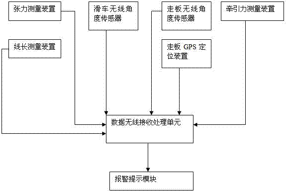
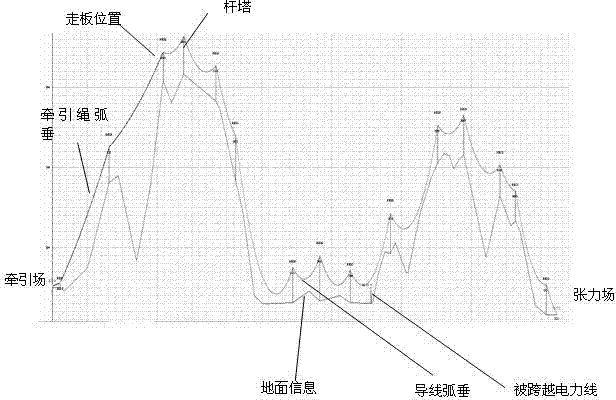
[0051] Embodiment 1: When the tackle wireless angle sensor is set on each base tower, the monitoring method of the present invention includes the following steps: (1), inputting the horizontal distance between each base tower and the distance between each base tower to the data wireless receiving and processing unit in advance The elevation of the ground, the GPS coordinates of each tower, the GPS coordinates of the crossed objects between each tower, and the information of the elevation and the ground; the data wireless receiving and processing unit automatically draws the information position map of the ground, crossed objects, and towers according to these information;
[0052] (2) The data wireless receiving and processing unit draws the wire sag curve of each gear between the tension machine and the running board: firstly, the GPS positioning device in the running board motion attitude measurement device and the GPS coordinate information of the tower are used to solve the ...
Embodiment 2
[0063] Embodiment two: when the tackle wireless angle sensor is arranged on the tackle of one of the base towers of the important gear, wherein the important gear is between two base towers with crossing objects on the ground, the monitoring method of the present invention includes the following steps: (1 ), pre-enter the horizontal distance between the base towers, the elevation of each tower from the ground, the GPS coordinates of each tower, the GPS coordinates of the objects spanned between each tower, and the elevation and ground information to the data wireless receiving and processing unit; The wireless receiving processing unit automatically draws the information position map of the ground, crossing objects, and towers according to these information;
[0064] (2) The data wireless receiving and processing unit draws the wire sag curve of each important gear between the tension machine and the walking board: firstly, the GPS positioning device in the walking board moveme...
PUM
 Abstract
Description
Claims
Application Information
 - R&D
- Intellectual Property
- Life Sciences
- Materials
- Tech Scout
- Unparalleled Data Quality
- Higher Quality Content
- 60% Fewer Hallucinations
Browse by: Latest US Patents, China's latest patents, Technical Efficacy Thesaurus, Application Domain, Technology Topic, Popular Technical Reports.
© 2025 PatSnap. All rights reserved.Legal|Privacy policy|Modern Slavery Act Transparency Statement|Sitemap|About US| Contact US: help@patsnap.com


