Method and device for generating digital elevation model from contour map

A technology of digital elevation model and contour map, applied in the field of geographic information, can solve the problem of high time consumption, achieve the effect of good data quality and improved calculation speed and efficiency

Active Publication Date: 2012-02-01
BEIJING DATUM TECH DEV
View PDF1 Cites 17 Cited by
  • Summary
  • Abstract
  • Description
  • Claims
  • Application Information

AI Technical Summary

Problems solved by technology

Different algorithms have different methods for selecting reference point sets, but when the DEM to be generated is massive data and the amount of contour map data is very large, the process of selecting the reference point set takes a very long time

Method used


Image

  • Method and device for generating digital elevation model from contour map
  • Method and device for generating digital elevation model from contour map
  • Method and device for generating digital elevation model from contour map

Examples


Embodiment Construction

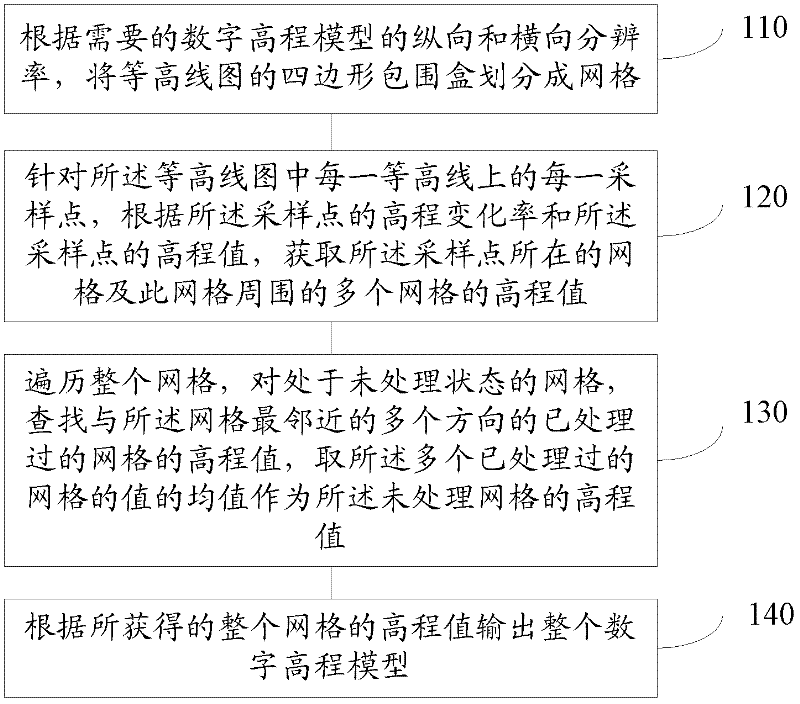
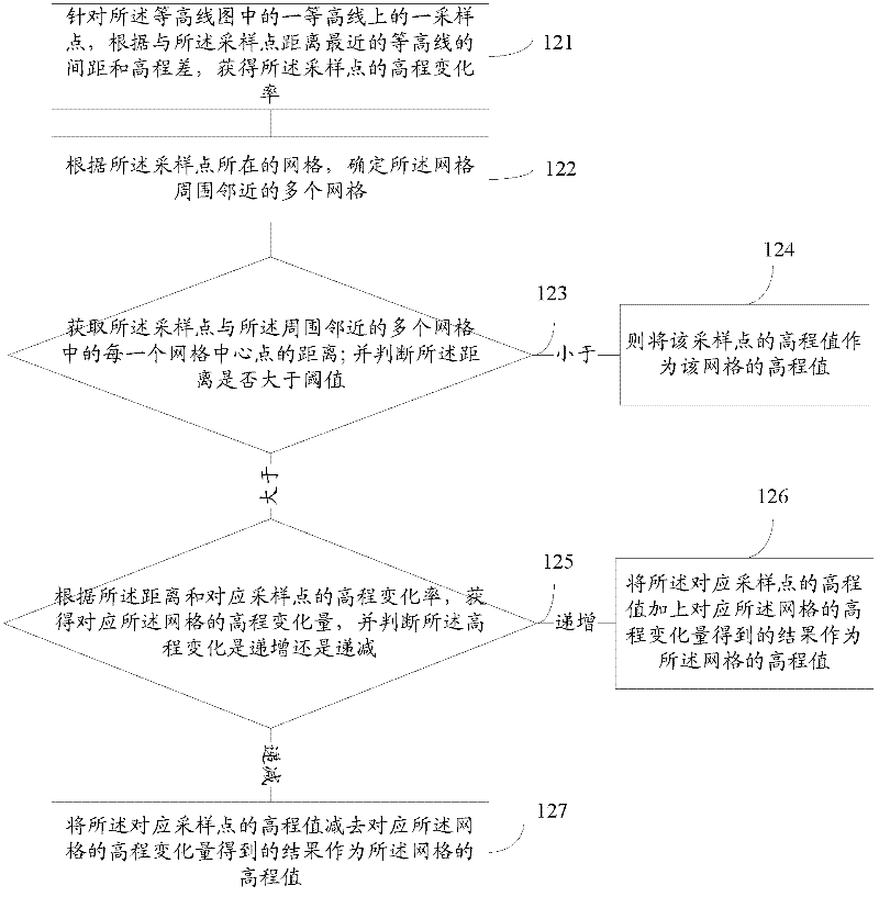
[0053] In order to make the above objects, features and advantages of the present application more obvious and comprehensible, the present application will be further described in detail below in conjunction with the accompanying drawings and specific implementation methods.

[0054] The present application obtains the elevation value of the grid where the sampling point is located and multiple grids around it by firstly obtaining the elevation change rate of each known sampling point and the elevation value of the sampling point, and then traverses the entire grid. For the unprocessed grid, look up the elevation values ​​of the processed grids in multiple directions closest to the grid, and take the mean value of the values ​​of the multiple processed grids as the unprocessed grid The elevation value of the grid is processed, so that the process of obtaining the elevation value of the entire grid does not need the process of selecting a reference point set to directly calculat...


PUM


Abstract

The application provides a method and a device for generating a digital elevation model from a contour map, which relate to the field of geographic information. The method comprises the steps that: a rectangular enclosing box of the contour map is divided into a grid according to the longitudinal and horizontal resolution of the required digital elevation model; the elevation values of the grid in which a sampling point is in and a plurality of grids around the grid are obtained according to the elevation changes of each sampling point on each contour line in the contour map and the elevation value of the sampling point; the whole grid is browsed, the elevation values of the treated grids which are most adjacent to the grid in a plurality of directions are searched for the grid which is not treated, and the average value of the values of the treated grids is adopted as the elevation value of the grid which is not treated; and the whole digital elevation model is output according to the elevation value of the whole grid. When the elevation value of the grid is obtained through the application, a dynamic effect model (DEM) is generated by direct calculation without selecting a reference point set, so that the computing speed and efficiency are obviously improved.

Description

technical field [0001] This application relates to the field of geographic information, in particular to a method and device for generating a digital elevation model from a contour map. Background technique [0002] Digital elevation model (Digital Elevation Model, abbreviated DEM) is a data set of plane coordinates (X, Y) and elevation (Z) of regular grid points within a certain range. It mainly describes the spatial distribution of regional landforms. It is formed by collecting data (including sampling and measurement) through high-line or similar three-dimensional models, and then performing data interpolation. DEM is a virtual representation of landforms. It can derive information such as contour lines and slope maps, and can also be superimposed with remote sensing images or other thematic data for analysis and applications related to terrain. At the same time, it is also the basis for making remote sensing images. data. Digital elevation model (DEM) is a basic data o...

Claims


Application Information

Patent Timeline
Patent Type & Authority Applications(China)
IPC IPC(8): G06T17/05
Inventor 史明昌黄兆伟李团宏曹刚孙成宝李嵩
Owner BEIJING DATUM TECH DEV
Why Eureka
Try Eureka