Relative positioning method for spatial object

A space target, relative positioning technology, applied in positioning, measuring devices, instruments, etc., can solve the problems of long convergence time and low positioning accuracy of single-star passive positioning

Inactive Publication Date: 2012-02-15
BEIJING UNIV OF POSTS & TELECOMM
View PDF6 Cites 21 Cited by
  • Summary
  • Abstract
  • Description
  • Claims
  • Application Information

AI Technical Summary

Problems solved by technology

[0003] 1. The convergence time of single satellite passive positioning is long and the positioning accuracy is low;
[0004] 2. The traditional multi-satellite cross positioning requires high-precision star coordinates, so it is necessary to use ground equipment or space-based navigation equipment to determine the position of the multi-satellite

Method used


Image

  • Relative positioning method for spatial object
  • Relative positioning method for spatial object
  • Relative positioning method for spatial object

Examples


Embodiment Construction

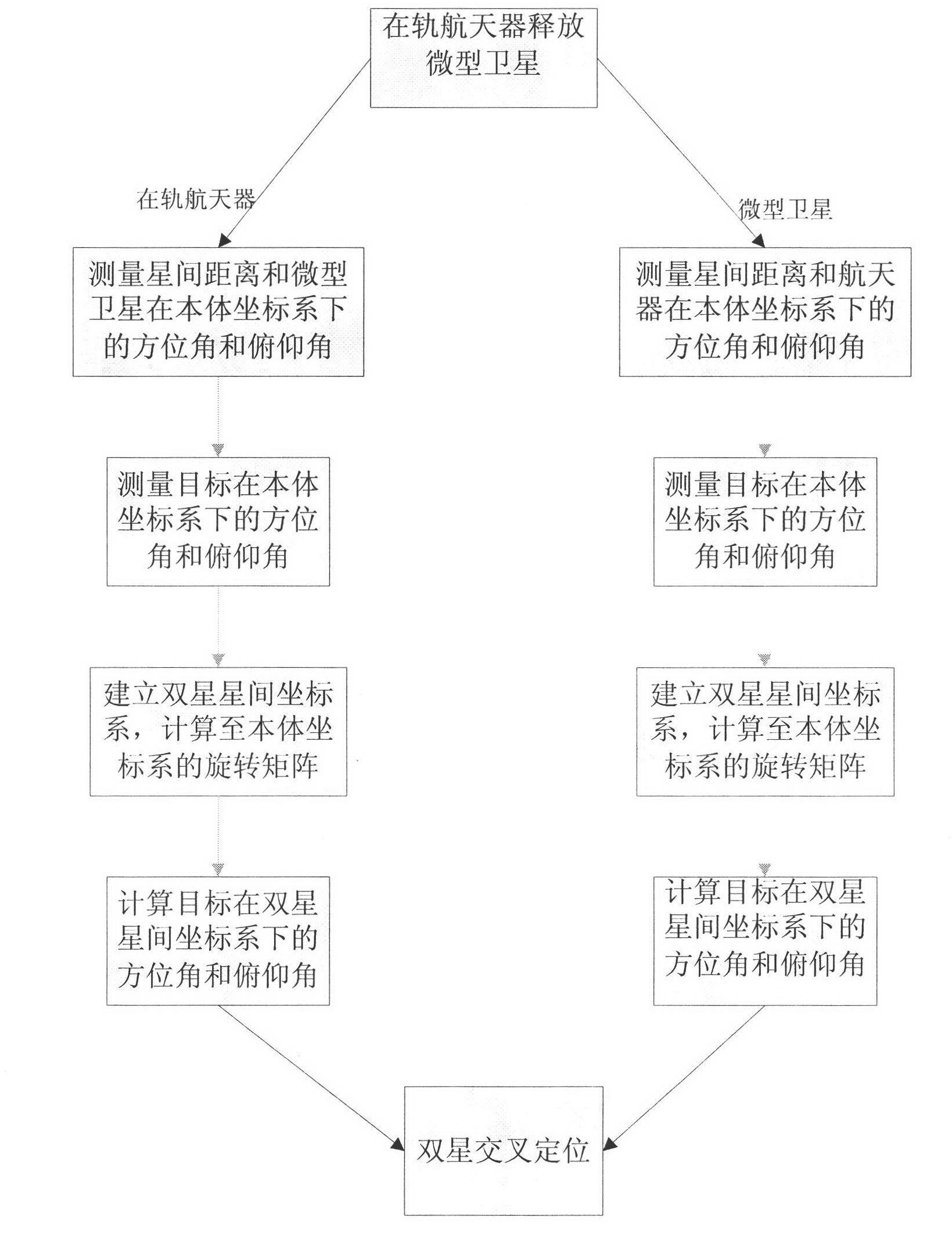
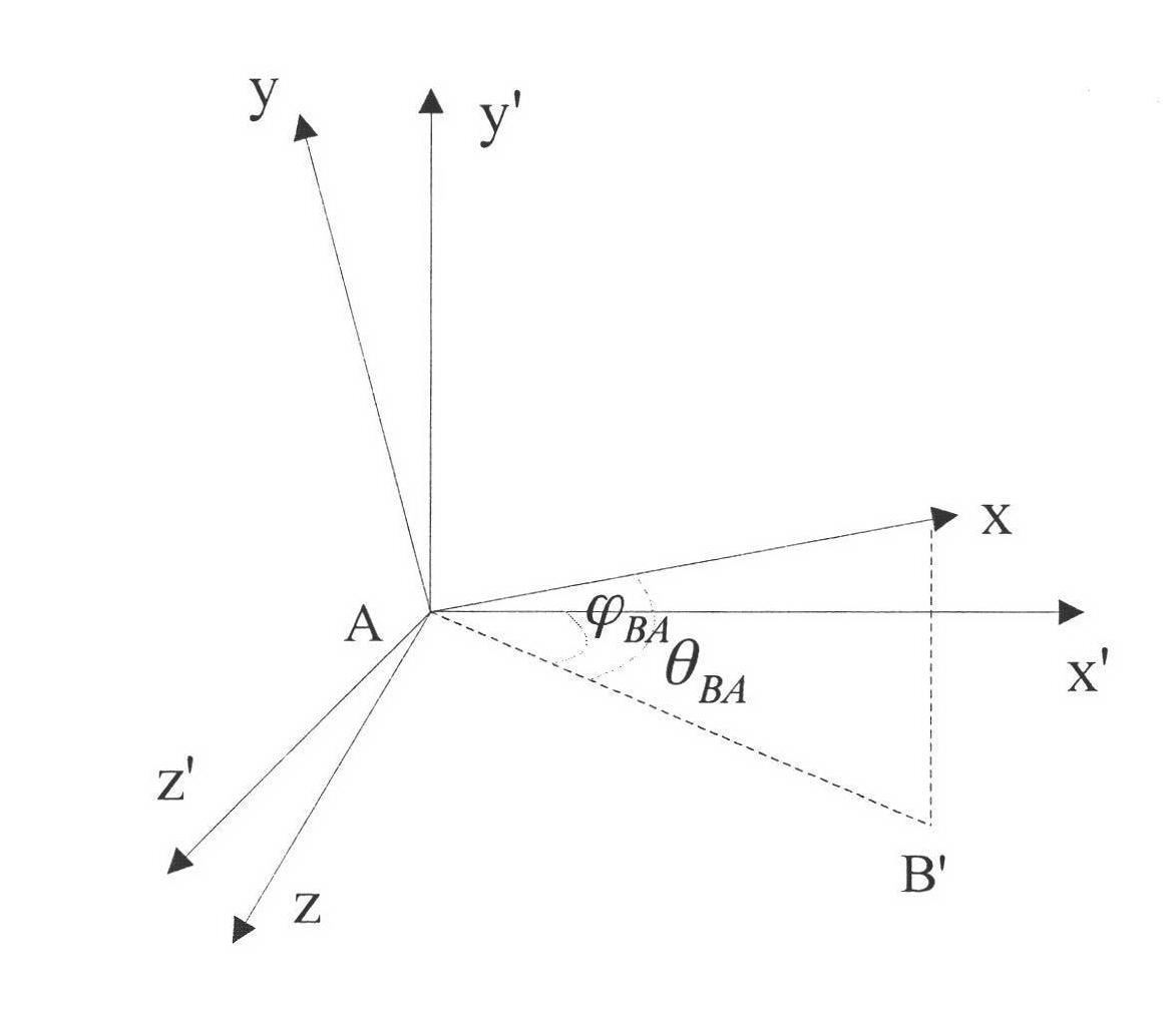
[0031] At first simply introduce several different coordinate systems used in the present invention and the conversion between coordinate systems:

[0032] (1) Satellite body coordinate system

[0033] The coordinate origin is located at the center of mass of the measuring satellite, the z-axis points to the center of the earth in the main symmetry plane of the satellite, the x-axis is perpendicular to the z-axis in the main symmetry plane of the satellite and points to the direction of satellite movement, and the y-axis is perpendicular to the main symmetry plane to form a right-handed coordinate system.

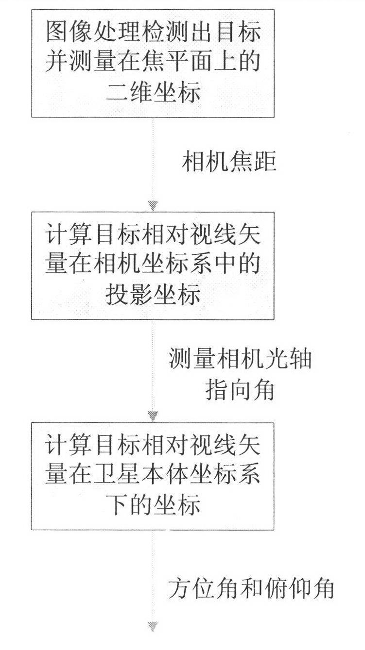
[0034] (2) Camera measurement coordinate system

[0035] The coordinate origin is located at the center of the entrance pupil of the camera optical system, the x-axis coincides with the camera optical axis, the z-axis is perpendicular to the x-axis in the main symmetrical plane of the camera and points to the center of the earth, and the y-axis forms a right-handed coordina...


PUM


Abstract

The invention discloses a relative positioning method for a spatial object. The method comprises the following steps of: releasing a micro satellite carrying a visible light camera by an on-track spacecraft; measuring the distance between the on-track spacecraft and the micro satellite by a microwave distance measurement method; measuring the azimuths and pitch angles of the on-track spacecraft and micro satellite in respective coordinate systems by the direction finding equipment; forming a double-star observation system from the on-track spacecraft and the micro satellite to observe the spatial object together; establishing a double-star inter-star coordinate system by taking the connection direction of the double stars as an X axis, wherein a Z axis is located in a plane formed by the double stars and the earth's core, is vertical to the X axis and points to the earth's core; calculating a transformation matrix from the coordinate system of the satellite to the double-star inter-star coordinate system; calculating the azimuth and pitch angle of the object in the double-star inter-star coordinate system through coordinate system transformation; and finally calculating the three-dimensional position of the spatial object by intersecting the sight lines of the double stars. In the invention, the relative relationship between the double stars is calculated firstly, a double-star inter-star coordinate system is established, then the azimuth and pitch angle measured by the coordinate system of the satellite are transformed to the double-star inter-star coordinate system through coordinate transformation, and finally the accurate position of the object is obtained by intersecting the sight lines of the double stars; the positioning speed is high, and the accuracy is high; and the method is particularly suitable for the real-time positioning for determining the space junk near the spacecraft.

Description

technical field [0001] The invention relates to spatial object positioning in the fields of image processing and pattern recognition. Background technique [0002] In the target recognition technology in the field of image processing and pattern recognition, spatial target positioning is a crucial link, and its positioning speed and accuracy directly affect the performance of the target recognition system. The current space target positioning methods mainly include passive positioning based on angle measurement of a single star to a target, multi-satellite cross positioning and other methods. The main disadvantages of these methods are: [0003] 1. The convergence time of single satellite passive positioning is long and the positioning accuracy is low; [0004] 2. The traditional multi-satellite cross positioning requires high-precision star coordinates, so it is necessary to use ground equipment or space-based navigation equipment to determine the position of the multi-sa...

Claims


Application Information

Patent Timeline
Patent Type & Authority Applications(China)
IPC IPC(8): G01S5/00G01C1/00
Inventor 孙汉旭叶平贾庆轩胡琦何雷杜宇楠
Owner BEIJING UNIV OF POSTS & TELECOMM
Why Eureka
Try Eureka