Method and system for supporting urban land utilization and traffic integrated planning policy

A decision support and land technology, applied in data processing applications, instruments, calculations, etc., can solve the problem of few practical applications

Inactive Publication Date: 2012-03-07
FUDAN UNIV +1
View PDF0 Cites 22 Cited by
  • Summary
  • Abstract
  • Description
  • Claims
  • Application Information

AI Technical Summary

Problems solved by technology

[0035] (3) Advantages and disadvantages of existing models
For example, the model of the relationship between traffic demand and land use is mainly a simple improvement of the traditional four-stage traffic demand forecasting model; for the study of the interaction between land use and traffic at the mesoscopic level (zoning), although a series of traffic and land use models have been established Uses relational mathematical models, but has fewer practical applications

Method used


Image

  • Method and system for supporting urban land utilization and traffic integrated planning policy
  • Method and system for supporting urban land utilization and traffic integrated planning policy
  • Method and system for supporting urban land utilization and traffic integrated planning policy

Examples


Embodiment 1

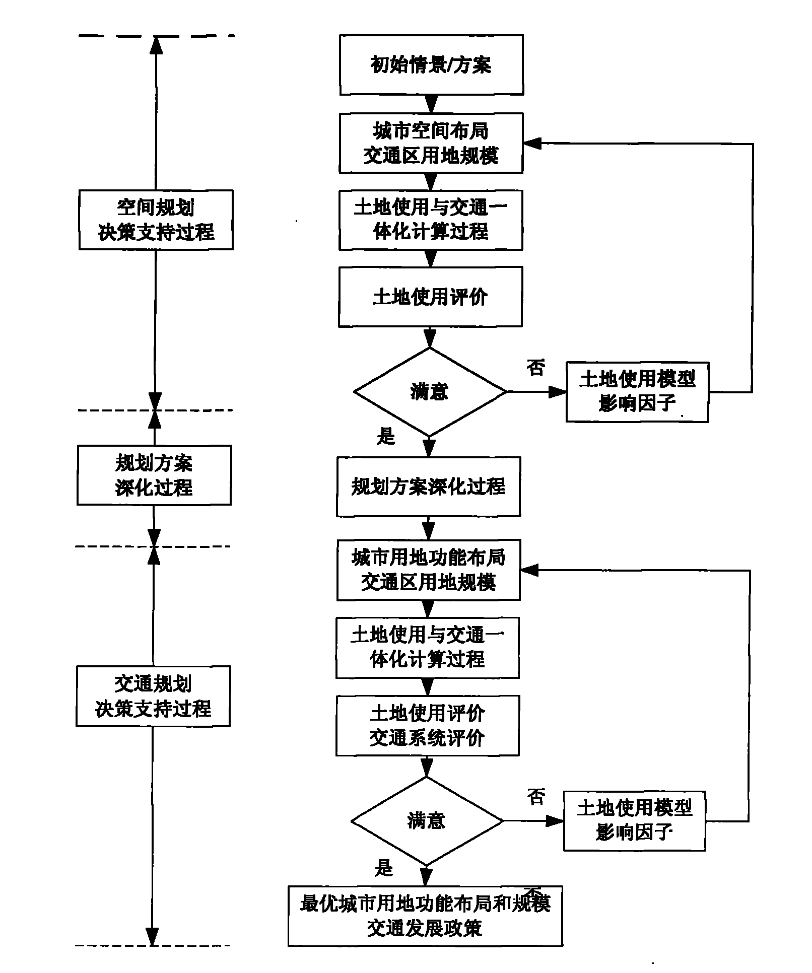
[0103] The integrated planning of urban land and transportation proposed by this system is an integrated planning idea corresponding to planning compilation, which provides technical support for the coordinated development of urban land use distribution and transportation planning, and is an innovation corresponding to the level of planning compilation. The successful implementation of the land use and transportation integrated planning decision support system also provides a good technical environment for the mutual combination of land use and transportation.

[0104] 1. Principles of Land Use and Transportation Integrated Planning Support System

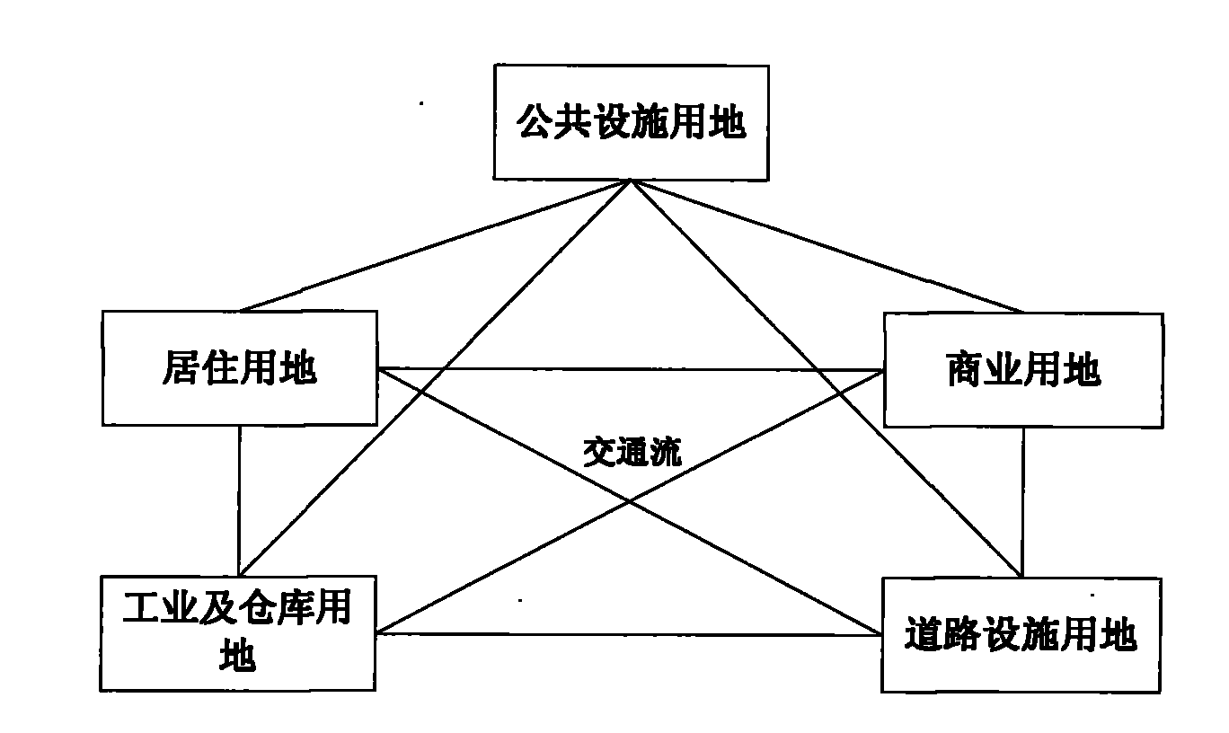
[0105] The complex interactive relationship between urban traffic and land use is manifested as a "source and flow" relationship on a macro level. As shown in the figure, this "source and flow" relationship also constitutes the city's traffic network system.

[0106] The relationship between land use and urban traffic is mainly refle...

Embodiment 2

[0268] A decision support system for integrated planning of urban land use and traffic, said system comprising: a land use model building block, a transport planning demand forecasting model building block, a convergence judging module, and a loop feedback module.

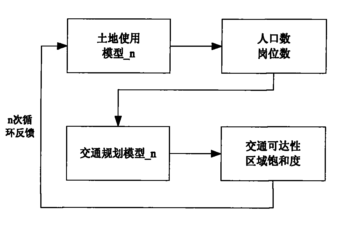
[0269] The land use model construction module is based on the land use planning of the research area in the planning year, transforms the existing urban basic data and various evaluation factors into the data format required in the land use model, and converts the transformed space supply data, evaluation factors input into land use models along with space demand data;

[0270] The traffic planning demand forecasting model building module is used to construct the framework of the traffic planning model according to the basic data of the city; then import the data obtained from the land use model into the traffic planning demand forecasting model as the basic data for constructing the traffic planning demand forecast...


PUM


Abstract

The invention discloses a method and system for supporting an urban land utilization and traffic integrated planning policy. The method comprises the following steps of: S1, constructing a land utilization model; S2, constructing a traffic planning demand predicting model; S3, judging a convergence property of a traffic accessibility value according to a traffic accessibility value result and an accessibility convergence index obtained according to the traffic planning demand predicting model, if a result indicates no convergence, executing an S4, and if the result indicates convergence, executing an S5; S4, feeding a result of the traffic planning demand predicting model back to the land utilization model, and returning to the S1 to restart a model computing process; and S5, stopping a cyclic feedback process, meanwhile, evaluating results of each land utilization scheme and each traffic planning scheme in real time when the cyclic feedback process is stopped, and selecting a preferential land utilization and traffic planning scheme. According to the invention, the urban land utilization and traffic planning can be realized automatically according to basic data, and the planning efficiency and the reasonableness, the scientificity and the continuity for planning can be improved.

Description

technical field [0001] The invention belongs to the technical field of urban planning, and relates to a planning decision-making support method, in particular to a decision-making support method for urban land use and transportation integration planning; at the same time, the invention also relates to a decision-making support method for urban land use and transportation integration planning system. Background technique [0002] The research on the integrated model of land use and transportation abroad started in the 1960s and developed rapidly after the 1980s, accumulating rich research experience and research results. The integration models are classified and commented on from different angles below. [0003] (1) Division based on different structures [0004] The current interaction models of urban land use and traffic can be basically divided into three types of structures: stand-along structure, connected structure and integrated structure. [0005] 1) Separation st...

Claims


Application Information

Patent Timeline
Patent Type & Authority Applications(China)
IPC IPC(8): G06Q10/00G06Q50/00
Inventor 苏海龙吴稼豪宋兵包渊秋谭迎辉曹娟娟傅淳沈永超高凤姣逄莹
Owner FUDAN UNIV
Why Eureka
Try Eureka