Terrain auxiliary navigation method based on mixture of terrain contour matching (TERCOM) algorithm and particle filtering

A terrain-aided navigation and terrain matching technology, applied in the direction of integrated navigator, can solve problems such as the inability of the aircraft to locate, filter divergence, initial position error, etc., to improve reliability and positioning accuracy, continuous and reliable positioning, and ensure reliability. Effect

Active Publication Date: 2012-04-25
BEIHANG UNIV
View PDF2 Cites 20 Cited by
  • Summary
  • Abstract
  • Description
  • Claims
  • Application Information

AI Technical Summary

Problems solved by technology

[0006] The technical problem to be solved by the present invention is to overcome the problems of the existing inertial terrain-aided navigation system with large initial position error, flat terrain area an

Method used


Image

  • Terrain auxiliary navigation method based on mixture of terrain contour matching (TERCOM) algorithm and particle filtering
  • Terrain auxiliary navigation method based on mixture of terrain contour matching (TERCOM) algorithm and particle filtering
  • Terrain auxiliary navigation method based on mixture of terrain contour matching (TERCOM) algorithm and particle filtering

Examples


Embodiment Construction

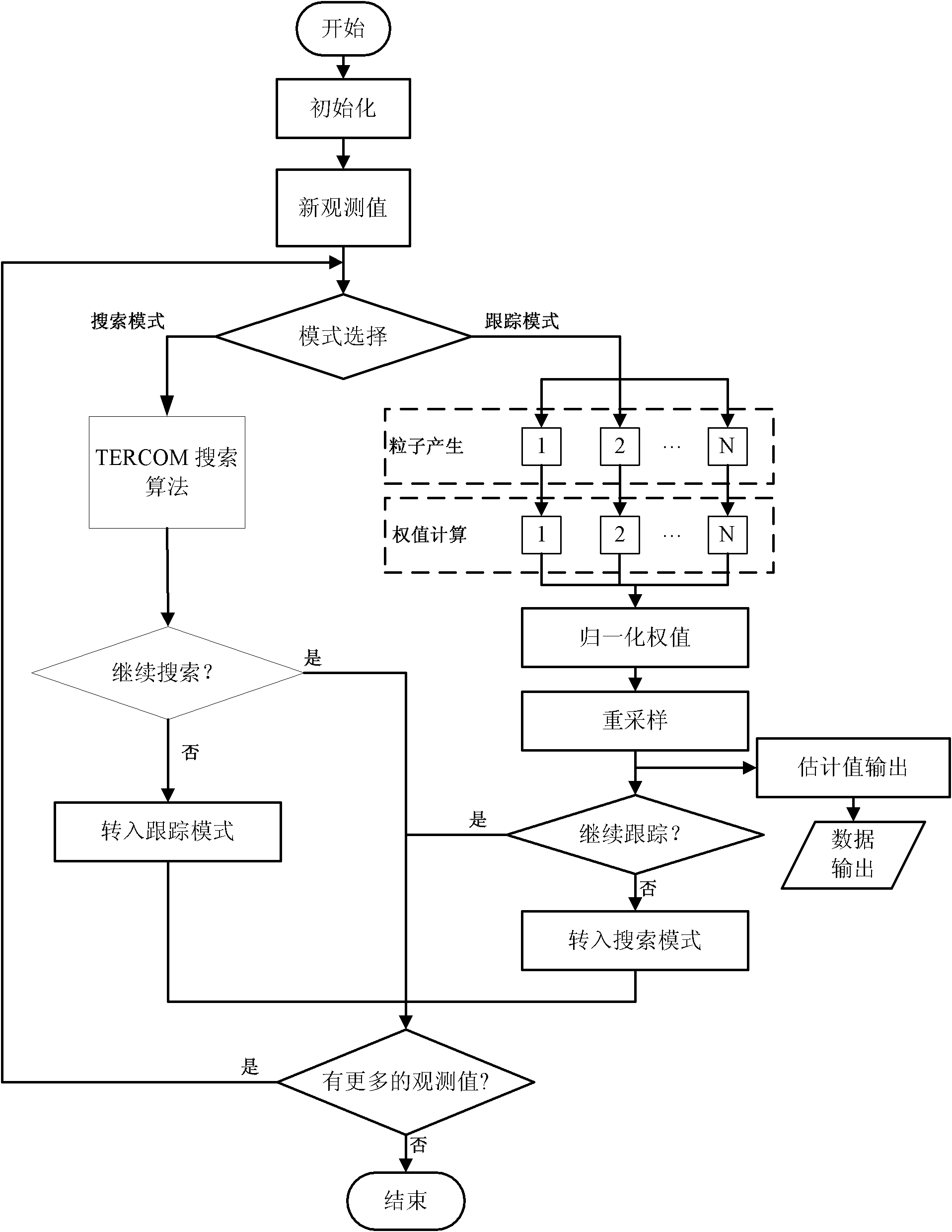
[0041] Below in conjunction with accompanying drawing and specific embodiment, the present invention is further described, and the specific implementation steps of the present invention are as follows:

[0042] (1) Algorithm initialization

[0043] Algorithm initialization includes matching area search size, initial particle distribution, initial position, velocity and attitude of inertial navigation system, origin coordinates of digital elevation basic map, map size and other information.

[0044] (2) Enter the matching area judgment

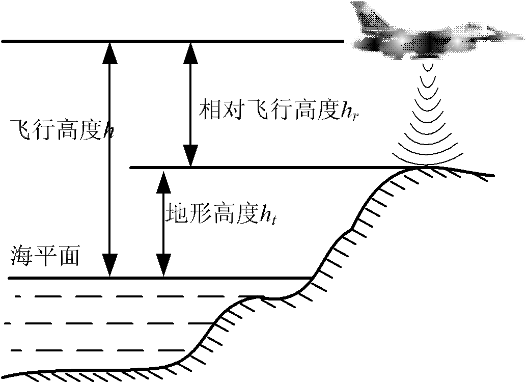
[0045] Such as figure 2 As shown, the inertial navigation system serves as the main navigation system to provide all navigation information, and the altitude h output by the radar altimeter r is the instantaneous distance from the aircraft to the ground, the altitude h is the instantaneous distance from the aircraft to the sea level output by the barometric altimeter or the air data computer alone or in combination with the inertial navigati...


PUM


Abstract

The invention provides a terrain auxiliary navigation method based on mixture of a terrain contour matching (TERCOM) algorithm and particle filtering, aiming at solving the problems of large initial position error and the diffusing of a wave filter when an aircraft flies at high maneuverability in a flat terrain region. The navigation method comprises a searching mode, a tracking mode, a losing mode and mode logical shift. In the searching mode, measurement information is processed in batches respectively by a mean absolute deviation (MAD) algorithm, a mean-square deviation (MSD) algorithm and a cross correlation (COR) algorithm, and initial positioning is quickly and exactly realized under the large initial position error according to a consistent voting algorithm; under the tracking mode, the measurement information is processed in a recurrence way by means of particle filtering, and the continuous matching and position can be realized under the tracking mode; and the searching mode is shifted into the tracking mode after the initial positioning is realized by the losing mode and the mode logical shift, and the tracking mode is shift to be the searching mode after pseudo positioning exists. The continuous positioning under the large initial position error can be guaranteed to be stably and reliably realized.

Description

technical field [0001] The invention relates to an inertial terrain-assisted navigation method, in particular to a terrain-assisted navigation method based on a mixed terrain contour matching TERCOM algorithm and a particle filter, which is suitable for terrain-assisted navigation and positioning systems of unmanned aircraft and manned aircraft. Background technique [0002] Unmanned aerial vehicles (UAVs and cruise missiles) used in modern military and civilian fields have higher and higher requirements for the accuracy and reliability of autonomous navigation systems, and require real-time and reliable information on the position, speed and attitude of unmanned aerial vehicles. Relying on a single navigation system is difficult to meet the requirements. The fusion of inertial navigation system and satellite positioning system information to provide carrier motion information has been widely used. However, because satellite positioning signals are susceptible to interferen...

Claims


Application Information

Patent Timeline
IPC IPC(8): G01C21/24
Inventor 赵龙陆守雷李萌赵君力刘昊
Owner BEIHANG UNIV
Why Eureka
Try Eureka