Measurement and calculation method for determining space boundary of city center area

A technology of spatial boundaries and central areas, applied in computing, instruments, data processing applications, etc., can solve problems such as ignoring architectural functions, and achieve obvious objectivity and accurate results

Inactive Publication Date: 2012-05-02
SOUTHEAST UNIV
View PDF0 Cites 3 Cited by
  • Summary
  • Abstract
  • Description
  • Claims
  • Application Information

AI Technical Summary

Problems solved by technology

First, the setting of the building height demarcation point is still based on subjective judgment; second, only considering the building height while ignoring the building function, it is possible to include a large number of high-rise residential blocks within the scope of the central area

Method used


Image

  • Measurement and calculation method for determining space boundary of city center area
  • Measurement and calculation method for determining space boundary of city center area
  • Measurement and calculation method for determining space boundary of city center area

Examples


Embodiment Construction

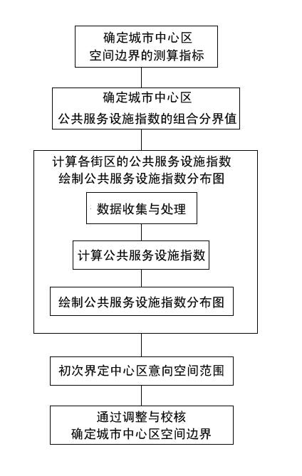
[0050] The technical solution of the present invention will be described in detail below in conjunction with the case of defining the spatial scope of the central area of ​​Nanjing and the accompanying drawings.

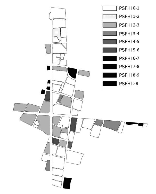
[0051] The method for determining the spatial boundary of the urban central area described in the present invention is used to determine the spatial boundary of the urban central area, which first determines the measurement index that can reflect the functional essence of the central area and can be objectively and accurately measured and calculated, and then According to the survey results of typical cities in my country, determine the combined cut-off value of the public service facility index in the urban central area; collect the original data, and draw the spatial distribution map of the measured index based on this, so as to delineate the spatial boundary of the urban central area.

[0052] Specifically, as figure 1 As shown, the above-mentioned method for deter...


PUM


Abstract

The invention provides a measurement and calculation method for determining space boundary of a city center area. The method comprises the following steps: firstly determining measurement and calculation indexes which can reflect functional essence of the center area and can be objectively and accurately measured and calculated; then determining combined boundary values of public service facility indexes of the city center area according to the survey result of the current situation of typical cities in China; collecting raw data and drawing a spatial distribution map of the measurement and calculation indexes; and finally demarcating the space boundary of the city center area by means of repeated adjustment and check. By adopting fully rational investigation standard, statistical precision and calculation method, the measurement and calculation method provided by the invention has the advantages of obvious objectivity, measurability, high data accuracy and uniqueness; and meanwhile the confusion situation of the city center area and other city areas can be prevented so as to obtain a more accurate result.

Description

technical field [0001] The invention relates to the technical field of urban planning, and relates to a measuring and calculating method for determining the spatial boundary of a city center area. Background technique [0002] After the 1950s, the city center has become one of the important research issues in the field of urban planning. Although people can generally point out the general location of a city center by intuition (such as Chongqing Jiefangbei area, Shenzhen Futian, Luohu area, Nanjing Xinjiekou area), but in-depth research on the land use structure, spatial composition, and building distribution of the central area First, there must be a clear spatial boundary, so that various data can find the basis for statistics and calculations, and comparative analysis between different cities or between different periods of the same city have practical significance. Therefore, in the study of the urban central area, the first thing to do is to clarify its spatial scope,...

Claims


Application Information

Patent Timeline
Patent Type & Authority Applications(China)
IPC IPC(8): G06Q90/00
Inventor 杨俊宴谭瑛
Owner SOUTHEAST UNIV
Why Eureka
Try Eureka