
Web geographic information system (GIS) based on java 2 platform enterprises edition (J2EE) and enterprises java bean (EJB)

A GIS server and server technology, applied in the field of J2EE/EJB-based WebGIS systems, can solve the problems of weak raster mode processing function, small data volume, and low interaction times, and achieve the effect of ensuring the ability to process vector data

Inactive Publication Date: 2012-05-09
SHANGHAI YAO WEI GROUP IND
View PDF3 Cites 3 Cited by
  • Summary
  • Abstract
  • Description
  • Claims
  • Application Information

AI Technical Summary

Problems solved by technology

[0005] The processing function of the raster mode on the client side is too weak, and the interaction with the server is frequent, but the amount of transmitted data is relatively small; the function of the vector mode is strong on the client side, and the number of times of interaction with the server is small, but the amount of data transmitted at one time is relatively large

Method used


Image

  • Web geographic information system (GIS) based on java 2 platform enterprises edition (J2EE) and enterprises java bean (EJB)
  • Web geographic information system (GIS) based on java 2 platform enterprises edition (J2EE) and enterprises java bean (EJB)
  • Web geographic information system (GIS) based on java 2 platform enterprises edition (J2EE) and enterprises java bean (EJB)

Examples


Embodiment 1

[0017] In order to compete with Microsoft, Sun Microsystems released the EJB specification, which is supported by a large number of companies and organizations such as IBM, Oracle, and BEA. Following the EJB specification makes it unnecessary for application developers to understand the details of low-level transactions and state management, multi-threading, resource sharing and other complex low-level APIs, so that they can focus on the development of business logic and easily build distributed applications. Because the J2EE inverted B model uses pure Java technology, it is more attractive than the COM+ model because of its cross-platform nature, that is, "write once, run anywhere". But it should also be noted that JavaBean is not as efficient as COM+ objects when implementing the same GIS function because Java uses a virtual machine mechanism.

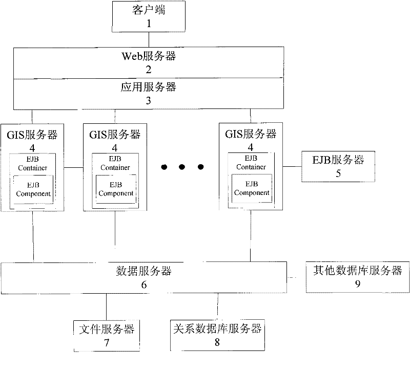
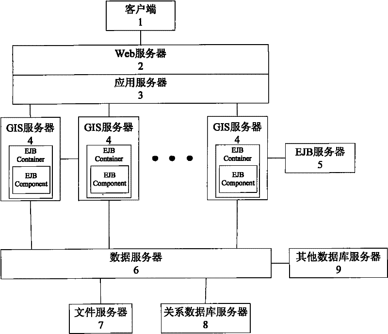
[0018] The implementation framework of WebGIS based on J2EE / EJB is as follows: figure 1 Shown, comprise client 1, Web server 2, ap...

Embodiment 2

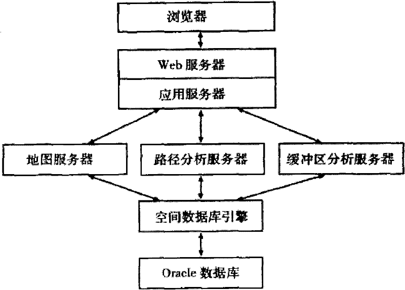
[0020] Such as figure 2 As shown in the figure, it is a logical block diagram to realize the functions of a website such as map release, information query, shortest path analysis, buffer analysis, and thematic map creation.

[0021] The function and performance test of the website was carried out, especially the concurrent user access test, which is an indispensable link before the release of the enterprise-level WebGIS system. The performance test of the website was carried out using the commercial software WebPer-formance2.0, and the results showed that due to the adoption of Object pool, instant activation, data caching and other technologies, the system supports 400 users concurrent access and 4000 users click and zoom operation at a rate of once every 1s for 10 minutes.


PUM


Abstract

The invention relates to a web geographic information system (GIS) based on a java 2 platform enterprises edition (J2EE) and an enterprises java bean (EJB), which comprises a client terminal, a Web server, an application server, GIS server, a data server and an EJB server. The client terminal is connected with the Web server through the Internet, the Web server is arranged on the application server which is connected with the GIS server, and the GIS server is respectively connected with the data server and the EJB server. The GIS server classifies map data into background data and thematic data, and sends the classified background data and the thematic data to the Web server. The Web server transmits the thematic data to the client terminal in vector mode, and enables the background data to be generated into images, and then the images are downloaded in the client terminal. Compared with the prior art, the web GIS based on the J2EE and the EJB has the advantaged of being capable of guaranteeing that the client terminal can process vector data, controlling data transmission quantity to the minimum and the like.

Description

technical field [0001] The present invention relates to a WebGIS system, in particular to a J2EE / EJB-based WebGIS system. Background technique [0002] The overall system structure of GIS has gone through the following four stages: stand-alone mode, centralized mode, client / server (C / s) mode and browser / server (B / s) mode. Traditional GIS mainly adopts the first three modes, among which the C / S mode is the highest form of its development. The C / S mode makes full use of the resources of the client computer, all calculations are performed on the client computer, the client computer and the server maintain a stable connection, and the server is used to access data intensively. The limitations of distributed enterprise-level GIS applications are obvious: a large number of public users cannot maintain a stable connection with the server, and there is not enough bandwidth to copy and transmit data smoothly; in addition, it needs to be installed separately on the client Specialize...

Claims


Application Information

Patent Timeline
Patent Type & Authority Applications(China)
IPC IPC(8): G06F17/30H04L29/06
Inventor 陈伟国姚薇
Owner SHANGHAI YAO WEI GROUP IND
Learn More