Geological measuring and marking instrument

A standard instrument and quality technology, applied in the field of geological quality standard instruments, can solve the problems of reduced measurement accuracy, abstract process, lack of strict basis, etc., to achieve the effect of guaranteed measurement accuracy, intuitive process and accurate measurement

Active Publication Date: 2015-04-22
CHINA UNIV OF GEOSCIENCES (BEIJING)
View PDF5 Cites 0 Cited by
  • Summary
  • Abstract
  • Description
  • Claims
  • Application Information

AI Technical Summary

Problems solved by technology

[0006] Existing technologies cannot realize rapid, intuitive and integrated systematic measurement of geological occurrence, spatial attributes and petrophysical properties
[0007] When measuring stratigraphic occurrence and spatial attributes, the main disadvantages of the above-mentioned traditional geological tools are: high cost of geological compass, complex operation, abstract process, and large human error in measurement
The compass uses abstract geometric methods to measure the occurrence of the formation and the orientation of the target, which is not intuitive enough. Users generally do not understand the principle and the purpose of each operation step. When the formation is close to vertical or horizontal, the measurement accuracy is greatly reduced; the instrument When not in use, the magnetic needle and the agate bearing are easy to wear each other, which affects the sensitivity; the hinge is often loosened, which will affect the measurement result; the shock resistance and drop resistance are poor, and it is easy to be damaged in field use
[0008] When measuring the physical properties of rocks, the main disadvantage of the above-mentioned traditional geological tools is that they cannot meet the requirements of standardization and quantitative-semi-quantitative research on certain physical properties of rocks.
For example: use a geological hammer to strike rocks, and judge rock hardness by sound and feel. There are too many subjective judgments and no strict basis; the magnifying glass can only roughly observe rock characteristics, and cannot determine density, hardness, particle size, roundness, and mineral percentage. Key geological information such as content and oil-gas content; when judging the color of rocks, it is also subjective, and there is no standardized comparison scale; when observing and measuring geological samples, the reference objects for image acquisition vary from person to person (coins, pencils, field books, geological hammer, etc.), there is no standardized unified measure
[0009] In geological research, the other disadvantages of the traditional geological tools mentioned above are: it is troublesome to carry in a unified way, easy to lose and easy to damage, the function is scattered and single, and the realization effect of multi-function and multi-channel cannot be achieved

Method used


Image

  • Geological measuring and marking instrument
  • Geological measuring and marking instrument

Examples


Embodiment Construction

[0031] The preferred embodiments of the present invention will be described below in conjunction with the accompanying drawings. It should be understood that the preferred embodiments described here are only used to illustrate and explain the present invention, and are not intended to limit the present invention.

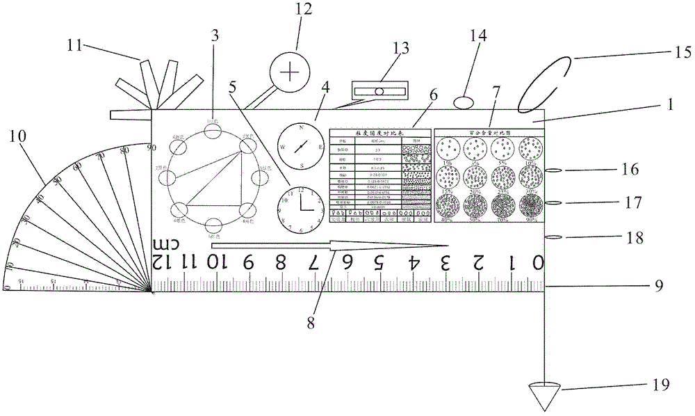
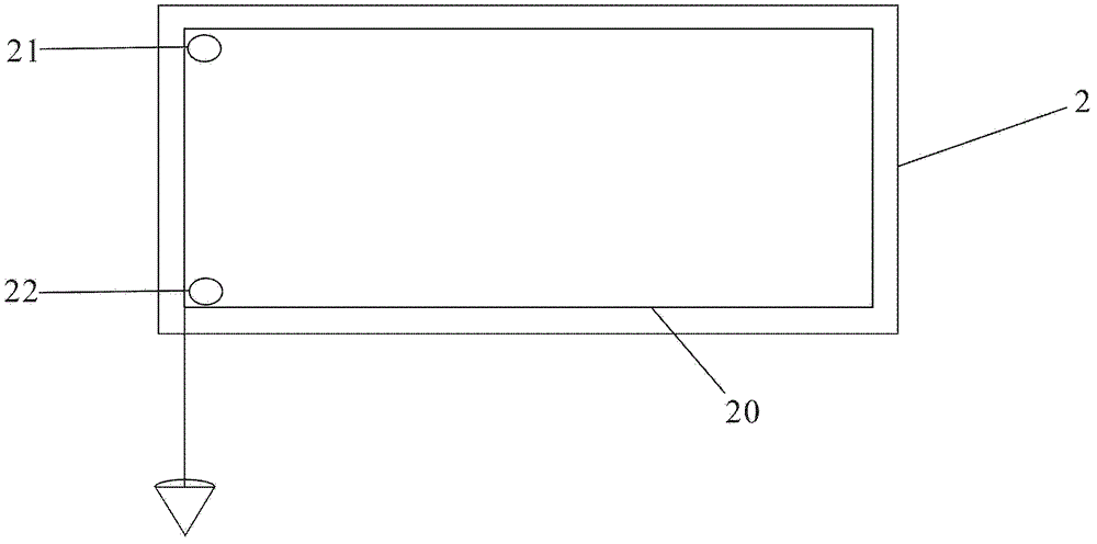
[0032] On the basis of the composite use of magnetic field and gravity field (in the past, gravity field was only indirectly used on the basis of magnetic field), the present invention uses a scale, a protractor, a compass, a spirit level and a plumb bob to directly measure geological elements such as the occurrence of the stratum. All-round measurement; use spatial geometry method (abstract geometry method was used in the past), intuitively measure the characteristics of spatial object elements, and directly realize the goal from spatial field to graphic positioning; use multiple scales to measure the main physical properties of rocks (color, density, etc.) , hardne...


PUM


Abstract

The invention discloses a geological measuring and marking instrument, which comprises a solid box; a panel is arranged on the surface of the solid box; a compass and a graduation ruler are arranged on the panel; the solid box is connected to a protractor, a gradienter and a lead hammer; furthermore, a petrophysical contrast ruler (a graph contrast ruler: a colorimeter, a granulometer, a roundness scale and a percentage content scale) is also arranged on the panel. The geological measuring and marking instrument disclosed by the invention is an integrated multifunctional combination type geological measuring and marking instrument, which relates to stratum attitude elements, space attribute characteristics and petrophysical measurement and has the advantages of being simple in structure, low in cost, intuitional in effect, convenient and rapid; multifunctional multi-channel high-precision measurement and judgement can be realized; the standardization and quantification-semi-quantification requirement can be satisfied; and systematic and integrated measurement on stratum attitudes, petrophysical properties and space attributes can be achieved.

Description

technical field [0001] The invention relates to geological tools, in particular to a geological quality scale instrument for systematic and integrated measurement of stratum occurrence, spatial attributes and petrophysical properties. Background technique [0002] In traditional field geological research, geological compass, geological hammer and magnifying glass are known as three treasures. The geological compass is mainly used to measure the occurrence and spatial characteristics of the rock formation according to the direction determined by the geomagnetic field; the geological hammer is mainly used to knock, take rock samples and feel the possible rock hardness; the magnifying glass is used to roughly observe the surface of the rock feature. [0003] The geological compass is composed of a magnetic needle, a dial, an inclinometer, an aiming target plate, and a level. The structure can be divided into a chassis, a casing, and an upper cover. The main components are fixe...

Claims


Application Information

Patent Timeline
Patent Type & Authority Patents(China)
IPC IPC(8): G01D21/02
Inventor 张金川韩双彪
Owner CHINA UNIV OF GEOSCIENCES (BEIJING)
Why Eureka
Try Eureka