Method for classifying remote sensing images blended with high-space high-temporal-resolution data by object oriented technology

A high-time resolution, object-oriented technology, applied in the field of land cover classification of remote sensing images, can solve the problems of inability to distinguish "different objects with the same spectrum" land cover types, and is not suitable for medium and low resolution remote sensing images, so as to improve accuracy and The effect of speed, clear geographical meaning

Inactive Publication Date: 2012-07-25
NORTHEAST INST OF GEOGRAPHY & AGRIECOLOGY C A S
View PDF1 Cites 34 Cited by
  • Summary
  • Abstract
  • Description
  • Claims
  • Application Information

AI Technical Summary

Problems solved by technology

[0006] In view of the problem that the previous remote sensing image classification method cannot distinguish the land cover types of "different objects with the sa

Method used


Image

  • Method for classifying remote sensing images blended with high-space high-temporal-resolution data by object oriented technology
  • Method for classifying remote sensing images blended with high-space high-temporal-resolution data by object oriented technology
  • Method for classifying remote sensing images blended with high-space high-temporal-resolution data by object oriented technology

Examples


specific Embodiment approach 1

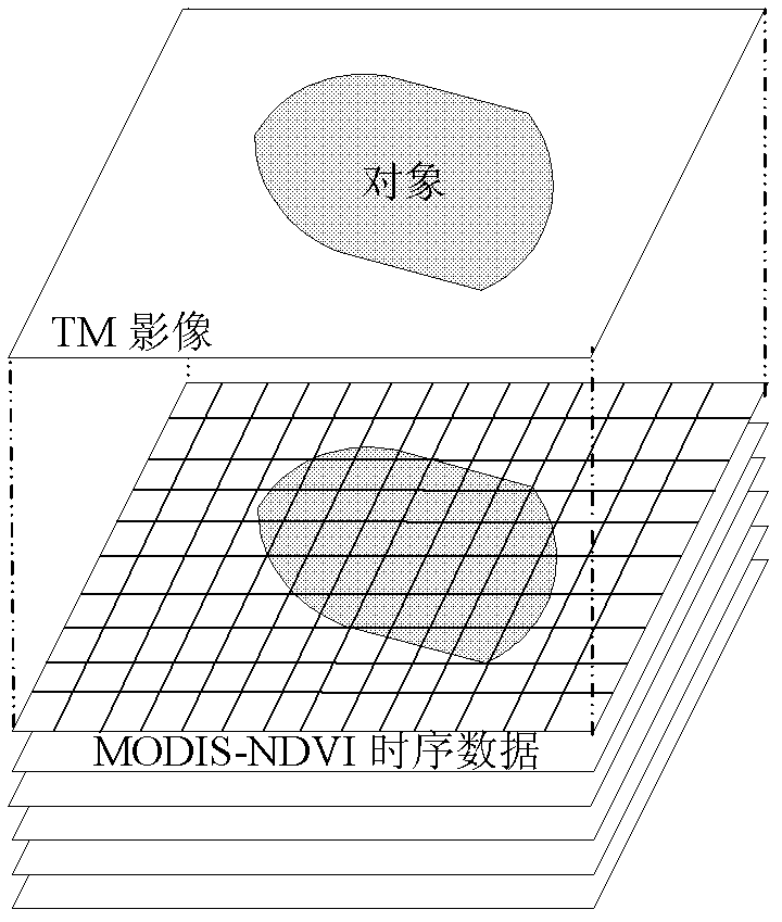
[0019] Specific implementation mode one: the following combination image 3 This embodiment will be described. The remote sensing image classification method using object-oriented technology to fuse high spatial and high temporal resolution data described in this embodiment includes the following steps:

[0020] Step 1: apply the Savitzky-Golay (SG) filter to filter the MODIS-NDVI time series data, remove error information, eliminate the noise generated by the sensor and the acquisition process, and obtain a stable phenology information source;

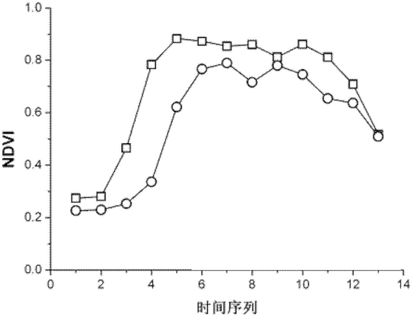
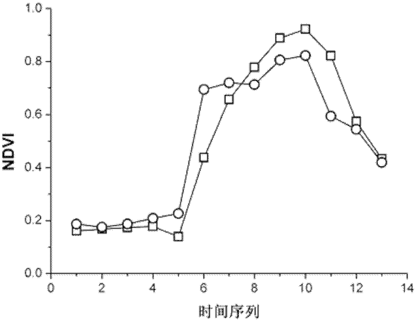
[0021] Step 2: From the stable phenological information source obtained in Step 1, determine the MODIS-NDVI time-series curve of typical vegetation in remote sensing images to be classified, that is, the phenological characteristics of typical vegetation;

[0022] Step 3: Use MODIS-NDVI time series data to obtain vegetation phenology information in the TM image to be classified, and perform multi-layer and multi-scale segmentation on...

specific Embodiment approach 2

[0027] Specific implementation mode two: the following combination figure 1 This embodiment is described. This embodiment is a further description of Embodiment 1. The non-vegetation objects mentioned in Step 5 of Embodiment 1 are water bodies, bare land, and artificial construction sites.

specific Embodiment

[0029] Step 1: Obtain the phenology information of various ground objects in the test area as training samples, and obtain the NDVI variation curve of typical vegetation types in the test area from the beginning of March to the end of September in 2009 according to the vegetation index product MOD13Q1 of the medium-resolution imaging spectrometer MODIS.

[0030] Step 2: Apply the Savitzky-Golay (SG) filter to filter the MODIS-NDVI time series data to remove noise to obtain stable phenological information.

[0031] Step 3: Carry out multi-scale segmentation on the Landsat TM image to obtain a series of spatially adjacent and homogeneous segmentation units, and take each unit as an object. Table 1 shows the parameter settings for multi-scale segmentation during object-oriented classification. The Landsat TM track number used for the test is P120R31, and the time is July 15, 2009.

[0032] Table 1.

[0033] Segmentation scale

color factor

form factor

smooth...


PUM


Abstract

The invention discloses a method for classifying remote sensing images blended with high-space high-time resolution data by an object oriented technology, and relates to a method for classifying remote sensing images of an oriented object, which can be used for solving the problem that the previous method for classifying remote sensing images can not be used for distinguishing land cover types of 'foreign bodies with the same spectrum', and is not suitable for being applied to the remote sensing images with low-medium resolution ratio. The method provided by the invention comprises the following steps: carrying out filter processing by applying an SG (screen grid) filter; determining a time sequence curve of typical vegetational MODIS-NDVI (moderate resolution imaging spectroradiometer-normalized difference vegetation index) in the remote sensing image to be classified; segmenting a TM (thematic mapper) image, wherein each segmentation unit is used as an object; extracting the characteristic information of each object; extracting all non-vegetation objects; removing the non-vegetation objects, and taking the obtained vegetational objects as planar vectors to segment MODIS-NDVI time sequence data, so as to obtain corresponding biotemperature information acquired by each vegetational object; and determining the vegetational type, to which each object belongs; and completing the land cover classification. The method provided by the invention can be used for distinguishing the land cover types.

Description

technical field [0001] The invention relates to a fast and accurate remote sensing image land cover classification method by using an object-oriented remote sensing image classification method to fuse high spatial resolution data (Landsat) and high time resolution data (MODIS-NDVI). Background technique [0002] The object-oriented remote sensing image interpretation method is compared with the traditional remote sensing image processing software, which mainly focuses on the interpretation algorithm of a single pixel. This method not only considers the spectral characteristics of ground objects, but also mainly uses their geometric and structural characteristics when classifying. The smallest unit in the image is no longer a single pixel, but an object. This method is a remote sensing information extraction method based on a cognitive model, which is closer to the human cognitive process, and has become one of the main research directions in the field of remote sensing infor...

Claims


Application Information

Patent Timeline
IPC IPC(8): G06K9/62G01C11/00
Inventor 贾明明刘殿伟王宗明任春颖汤旭光董张玉邵田田
Owner NORTHEAST INST OF GEOGRAPHY & AGRIECOLOGY C A S
Why Eureka
Try Eureka