A Generation Method of Surface Vegetation Covering Model in 3D Visualization Environment

A technology of surface vegetation and coverage models, applied in the design of geographic information systems and remote sensing, can solve the problems of fragmented results, lack of geographical significance, and failure to meet the requirements of geographic information system polygons, etc., and achieve the effect of high precision and speed

Active Publication Date: 2018-09-25
GEOVIS CO LTD
View PDF5 Cites 0 Cited by
  • Summary
  • Abstract
  • Description
  • Claims
  • Application Information

AI Technical Summary

Problems solved by technology

[0004] At present, the research on land vegetation cover classification at home and abroad is mainly focused on the classification of low- and medium-resolution remote sensing images. This method is a traditional pixel-based classification, and the results are often fragmented and do not have clear geographical significance. Geographic Information System Requirements for Polygons

Method used


Image

  • A Generation Method of Surface Vegetation Covering Model in 3D Visualization Environment
  • A Generation Method of Surface Vegetation Covering Model in 3D Visualization Environment
  • A Generation Method of Surface Vegetation Covering Model in 3D Visualization Environment

Examples


Embodiment Construction

[0023] In order to better understand the present invention, the method of the present invention will be further described below with reference to the description of the embodiments in conjunction with the accompanying drawings.

[0024] In the following detailed description, numerous specific details are set forth in order to provide a thorough understanding of the present invention. However, it will be understood by those skilled in the art that the present invention may be practiced without these specific details. In the embodiments, well-known methods, procedures, components have not been described in detail so as not to unnecessarily obscure the embodiments.

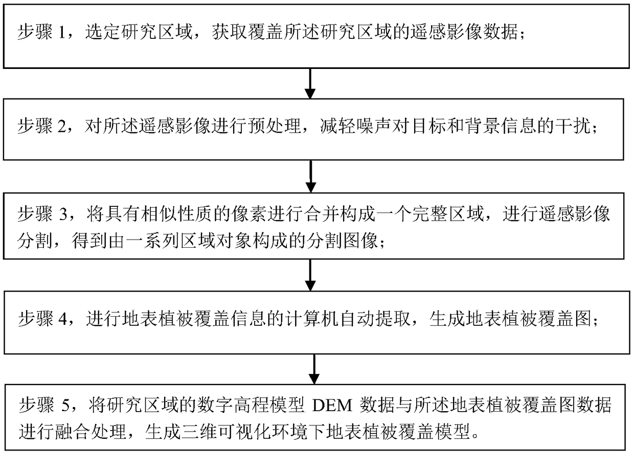
[0025] see figure 1 Shown, the generation method of ground vegetation cover model under a kind of three-dimensional visualization environment of the present invention is characterized in that:

[0026] Step 1, select a research area, and obtain remote sensing image data covering the research area;
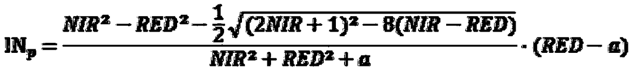
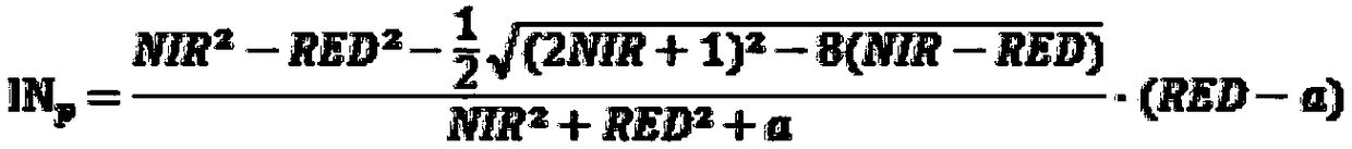
[0027] Step 2,...


PUM


Abstract

A method for generating a surface vegetation coverage model in a three-dimensional visualization environment, characterized in that: obtaining remote sensing image data covering the research area; preprocessing the remote sensing image; merging pixels with similar properties to form a complete area Carry out remote sensing image segmentation; perform computer automatic extraction of surface vegetation coverage information to generate a surface vegetation coverage map; fuse the digital elevation model DEM data of the research area with the surface vegetation coverage map data to generate a three-dimensional visualization environment of the surface vegetation Override the model. The invention combines the advantages of object-oriented classification technology and vegetation index identification technology, overcomes the difficulty of distinguishing "different objects with the same spectrum" land cover types by using object-oriented classification technology alone, and also solves the problem of fragmentation of classification results by using spectral features alone , Issues that do not have clear geographical significance. And a unique vegetation coverage index is adopted, which makes the vegetation identification of remote sensing images have higher accuracy and speed.

Description

Technical field: [0001] The invention relates to the technical fields of geographic information system and remote sensing, and specifically relates to a method for generating a vegetation coverage model on a surface in a three-dimensional visualization environment. Background technique: [0002] Vegetation remote sensing monitoring is an important part of the application of remote sensing technology in the field of land use. Remote sensing technology, as the cutting-edge technology of earth information science, can continuously obtain large-scale ground information in a short period of time, realize rapid collection and quantitative analysis of vegetation information, respond quickly, and have strong objectivity. It is currently the most effective earth observation technology and information means of acquisition. Especially in recent years, the development of new high spatial resolution, hyperspectral, radar and other remote sensing technologies has provided new opportuniti...

Claims


Application Information

Patent Timeline
Patent Type & Authority Patents(China)
IPC IPC(8): G06K9/00G06K9/40G06K9/34G06K9/46
CPCG06V20/188G06V10/267G06V10/30G06V10/56
Inventor 田媛杜敬巩志远谢国钧李宇光
Owner GEOVIS CO LTD
Why Eureka
Try Eureka