High-performance cache design method orienting to massive spatial information

A design method and spatial information technology, applied in computing, instrumentation, electrical digital data processing, etc., can solve the problems of data access performance discount, unsupported spatial index, difficult to support geographic information query, etc., to meet data access requirements, high The effect of high access performance and memory access efficiency

Inactive Publication Date: 2012-09-19
PEKING UNIV
View PDF3 Cites 19 Cited by
  • Summary
  • Abstract
  • Description
  • Claims
  • Application Information

AI Technical Summary

Problems solved by technology

However, limited by strict database transactions and integrity constraints, its data access performance is greatly reduced
[0004] Among the recently popular NoSQL databases, CouchDB and MongoDB have added GeoHash as a spatial index to support spatial queries. The two can use memory to cache some data, but they still use hard disk storage as the main storage, and only support point-shaped data queries. No complex geometric data structure support
Redis implements the scheme of putting all data in memory and provides ultra-high performance data access. However, Redis currently does not support spatial indexing, so it is difficult to support geographic information queries.

Method used


Image

  • High-performance cache design method orienting to massive spatial information
  • High-performance cache design method orienting to massive spatial information

Examples


Embodiment Construction

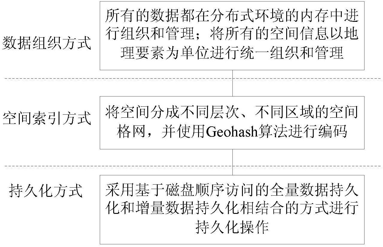
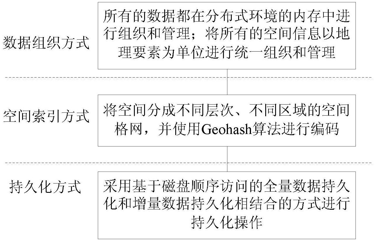
[0022] The technical solution provided by the present invention specifically includes the following three aspects: data organization, spatial index, asynchronous persistence (such as figure 1 shown).

[0023] 1. Data organization

[0024] Geographical feature data in traditional databases takes layers as organizational units, and geographical features are stored as a record in a layer. For the operation of a geographic feature in the layer, it is necessary to ensure that the transaction characteristics and integrity constraints of the layer are met. The characteristic of the data organization in the present invention is to cancel the role of the layer as the data organization unit, and further discard the complex transaction and integrity constraints on the table in the traditional database. Organize and manage all geospatial information in units of geographic elements.

[0025] (1.1) When the cache starts working, it will read geographic features one by one from a traditio...


PUM


Abstract

The invention discloses a high-performance cache design method orienting to massive spatial information. The high-performance cache design method comprises the steps of: organizing and managing all data in a memory of a distributed environment; performing unified organization and management on all space information by taking geographic elements as units; dividing a space into spatial grids of different layers and different zones, and encoding by using a Geohash algorithm; and performing persistence operation in a manner of combining full data persistence and incremental data persistence basedon sequential disk accesses. According to the technical scheme disclosed by the invention, the advantage of high memory access efficiency can be fully used to achieve higher access performance for geospatial data, so that the requirement for supporting massive concurrent data accesses is met.

Description

technical field [0001] The invention belongs to the field of high-performance geographic information computing, and in particular relates to a high-performance cache design method for large-scale spatial information in a distributed environment of multiple machines at the server end. Background technique [0002] With the development of the Internet and mobile technology, more and more information is related to geographic location, and more and more people can access geographic information through the network. This places high demands on the performance of accessing geolocation information. At present, the general-purpose hard disk-based spatial data storage has the bottleneck of low hard disk access performance. On the other hand, hardware technology is still developing rapidly, and the capacity of memory is constantly increasing, while the price is constantly falling. This makes it possible to store large amounts of data in memory. The efficiency of memory-based data ac...

Claims


Application Information

Patent Timeline
Patent Type & Authority Applications(China)
IPC IPC(8): G06F17/30
Inventor 高勇郁浩刘磊闫梦龙
Owner PEKING UNIV
Why Eureka
Try Eureka