Island-air triangular measuring method based on GPS/IMU positioning and orientating technology

An aerial triangulation, positioning and orientation technology, applied in the field of aerial photogrammetry, can solve problems such as no control points on islands, poor texture in sea areas, and aerial photographs falling into the water.

Inactive Publication Date: 2012-10-10
扬州德可达科技有限公司
View PDF4 Cites 9 Cited by
  • Summary
  • Abstract
  • Description
  • Claims
  • Application Information

AI Technical Summary

Problems solved by technology

[0006] The technical problem to be solved by the present invention is: there is no control point on the island, a large number of aerial photos "fall into the water", and the texture of the sea area near the island is poor, and it is impossible to obtain enough connecting points to construct an area network to realize aerial triangulation.

Method used


Image

  • Island-air triangular measuring method based on GPS/IMU positioning and orientating technology
  • Island-air triangular measuring method based on GPS/IMU positioning and orientating technology
  • Island-air triangular measuring method based on GPS/IMU positioning and orientating technology

Examples


Embodiment Construction

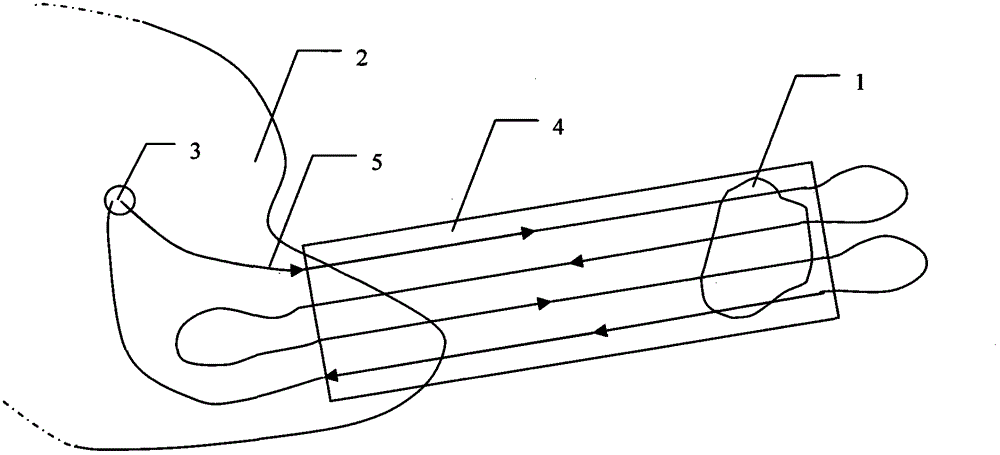
[0017] Such as figure 1 As shown, for the target island 1 without control points, when performing aerial photography of stereoscopic mapping, an aircraft with an aerial photography system equipped with high-precision GPS / IMU positioning and orientation equipment must be used to set off from the base 3 of the land bank 2, The edge area of ​​shore 2, the target island 1 and the water area between them are aerial photographed according to flight route 5, and the image sequence with sufficient overlapping degree of area 4 is obtained. Has at least one geode control point.

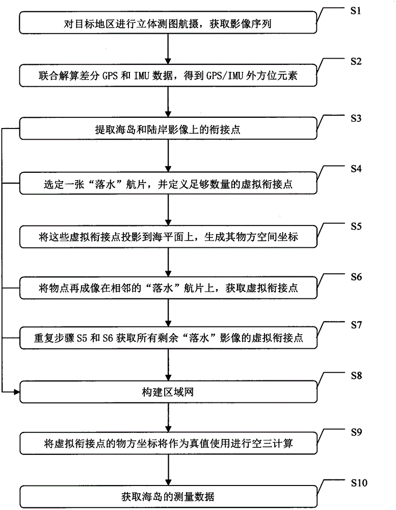
[0018] An island air triangulation method based on GPS / IMU positioning and orientation technology, such as figure 2 As shown, the specific steps are as follows:

[0019] Step S1: Use the aerial photography system with high-precision GPS / IMU positioning and orientation equipment to conduct stereoscopic mapping and aerial photography of the target islands and sea areas and land and shore survey areas with geod...


PUM


Abstract

The invention relates to the fields of aerial photogrammetry and particularly relates to an island-air triangular measuring method based on a GPS/IMU (Global Position System/Inertial Measurement Unit) positioning and orientating technology. The technical scheme adopted by the invention is that an aerial photography system with high-precision GPS/IMU positioning and orientating equipment is used for carrying out three-dimensional aerial mapping for a target island and sea and a land and shore measuring region with a land control network, extracting joint points of images on the island and the land and shore and directly carrying out virtual joint point generation on fall-water images according to exterior orientation elements solved based on GPS/IMU data, thus realizing the air triangular measurement and calculation by adopting a bundle method and further solving exterior orientation elements of the island, the land and the shore and corresponding object point land coordinates. According to the island-air triangular measuring method disclosed by the invention, the difficult problem that the island measurement cannot be controlled is effectively solved, the foundation for large-medium proportional scale mapping of the island is laid; and meanwhile, the problem of aerial photogrammetry of other measuring regions with poor and single textures (such as deserts, grasslands and snow fields) can be effectively solved.

Description

technical field [0001] The invention relates to the field of aerial photogrammetry, in particular to an island air triangulation method based on GPS / IMU positioning and orientation technology. Background technique [0002] Aerial triangulation, also known as aerial triangulation, is a key technology and step in the process of aerial photogrammetry data processing. The position and attitude of , that is, to obtain the 6 outer orientation elements of each aerial photo: Modern aeronautical triangulation is based on the beam method, that is, through iterative adjustment of the outer orientation elements of overlapping aerial photos, the spatial intersection of beams with the same name is realized, so as to finally determine the outer orientation elements of each aerial photo. The mathematical formula used is the collinear equation: the object point in the object space, the projection center of the aerial camera lens and the imaging point of the object point on the aerial photo...

Claims


Application Information

Patent Timeline
Patent Type & Authority Applications(China)
IPC IPC(8): G01C11/34
Inventor 唐粮
Owner 扬州德可达科技有限公司
Why Eureka
Try Eureka