Method for monitoring soil erosion based on unmanned aerial vehicle aerial photography

A technology for aerial photography and soil erosion, applied in photogrammetry/video surveying, measuring devices, mapping and navigation, etc., can solve the problems of high price, low precision and long cycle of remote sensing images

Inactive Publication Date: 2012-10-24
翼航东升东莞航空实业集团有限公司
View PDF1 Cites 26 Cited by
  • Summary
  • Abstract
  • Description
  • Claims
  • Application Information

AI Technical Summary

Problems solved by technology

[0003] ① When setting up ground sample plots and runoff plots for regular measurement, the action is slow, the workload is large, a large amount of manual input is required, the cost is high, and the cycle is long;
[0004] ②The use of ordinary manned aerial remote sensing is relatively expensive due to the need for many links such as transitions, and it is difficult to carry out frequently, and the safety is poor;
[0005] ③When space satellite remote sensing is used for monitoring, the temporal and spatial resolution is low, and the flight altitude is above the clouds, the image clarity is greatly affected by the clouds, and the erosion is mostly distributed in mountainous areas with complex terrain, so the accuracy is low, while the high resolution remote sensing imagery is expensive, and is also limited by the revisit cycle and the influence of clouds
[0006] Therefore, in the process of soil erosion investigation, when using traditional methods such as setting ground plots, runoff plots, manned aerial remote sensing and space satellite remote sensing, it will inevitably bring a lot of trouble and low efficiency.
Therefore, the existing technology has disadvantages such as high cost, long period, great influence by clouds, and poor security. How to reduce the cost, shorten the image update cycle, improve image clarity, and increase security without affecting the accuracy of aerial surveys has become an important issue. Problems to be Solved Urgently by Scientists and Technologists in the Field

Method used


Image

  • Method for monitoring soil erosion based on unmanned aerial vehicle aerial photography
  • Method for monitoring soil erosion based on unmanned aerial vehicle aerial photography
  • Method for monitoring soil erosion based on unmanned aerial vehicle aerial photography

Examples


Embodiment Construction

[0039] First select the research area, set the parameters of the integrated digital camera, differential GPS and gyro platform in the drone, set up the drone according to the weather, the location of the research area, etc., fly the drone, and take pictures in the research area , Obtain the image data, output the data, and process the image in the computer digital image processing system.

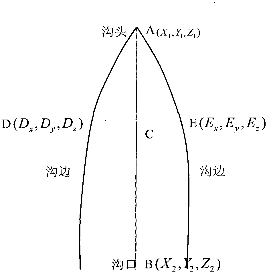
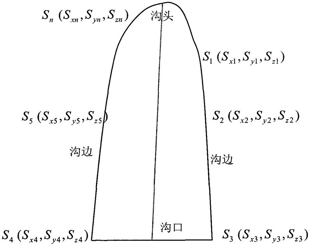
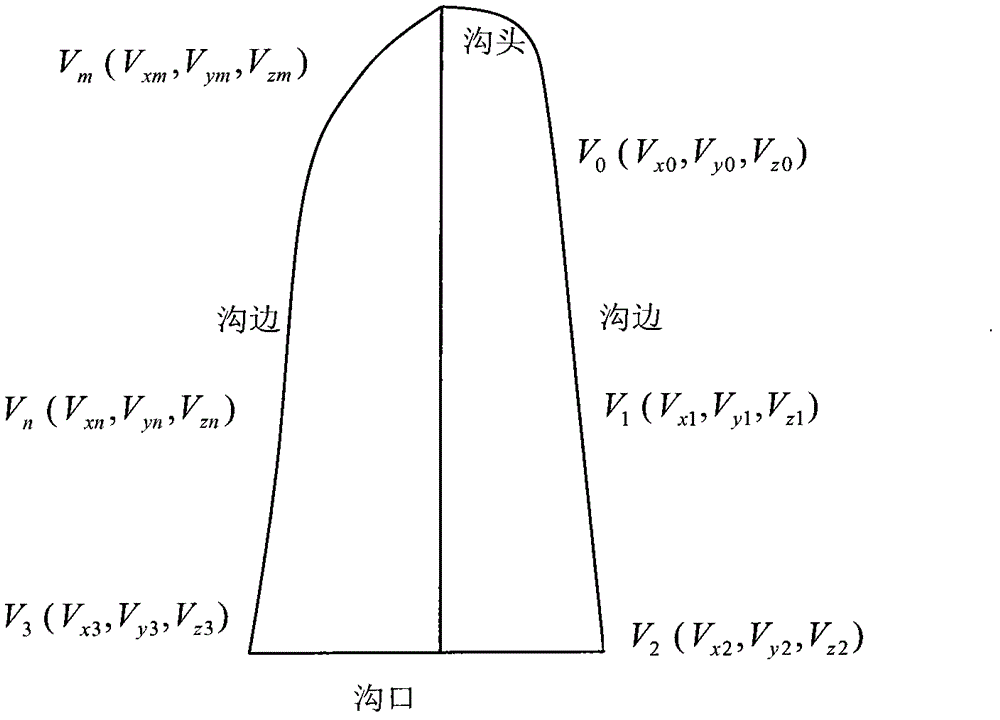
[0040] Import the processed image map into CAD, and identify and measure the quantity and quality of the investigation factors of the erosion development degree of the soil erosion area on the image. According to the factors interpreted on the image, including the length, width, and depth of the trench , Volume and other factors.

[0041] The method of measuring the length of the erosion channel is as follows: through the computer digital image processing system, the digital camera, differential GPS, gyroscope, and digital photography technology in the remote sensing platform of the UAV low-alti...


PUM


Abstract

The present invention discloses a method for monitoring soil erosion based on unmanned aerial vehicle aerial photography. The method is characterized by: adopting an unmanned low altitude aerial vehicle as a remote sensing platform, and integrating a digital camera, a differential GPS and a gyro platform; adopting a digital photography technology, and adopting a low altitude unmanned aerial vehicle with characteristics of high resolution and large scale to acquire a plurality of long-period observation image data of a research area; adopting a computer digital image processing system to import a processed image into a CAD; carrying out recognition and measurement on quantity and quality of soil erosion investigation factors in the CAD based on culture conformation law and image characteristics in the research area, wherein the factors comprise length, width, depth, volume and other factors of a channel; and calculating values of channel head advancing, channel widening, and channel down-cutting, and then calculating channel erosion and an average erosion modulus in many years so as to monitor soil erosion change in the whole research area, such that a convenient and efficient method is provided for good treatment and monitor of water and soil loss.

Description

1. Technical Field [0001] The invention relates to a method for monitoring soil erosion, in particular a method for monitoring soil erosion based on drone aerial photography. 2. Technical background [0002] The traditional soil erosion survey method is to set up ground samples and conduct regular measurements. At the same time, aerial remote sensing and space satellite remote sensing are commonly used for surveys, but the above-mentioned technologies have their obvious shortcomings and shortcomings: [0003] ① When setting up ground sample plots and runoff plots for regular actual measurement, the action is slow, the amount of labor is large, a large amount of labor is required, the cost is high, and the cycle is long; [0004] ②Using ordinary manned aerial remote sensing requires high cost due to many links such as transfer, which is difficult to carry out frequently and has poor safety; [0005] ③When using space satellite remote sensing monitoring, its temporal and spatial resolut...

Claims


Application Information

Patent Timeline
Patent Type & Authority Applications(China)
IPC IPC(8): G01C11/00G01N21/84
Inventor 冯仲科吴斌仇琪高原何诚
Owner 翼航东升东莞航空实业集团有限公司
Why Eureka
Try Eureka