Method for generating polygonal chain with concentrated topology of geographic information system

A geographic information system and polygon technology, applied in the field of polygon chain generation, can solve the problems of reducing the time efficiency and high time complexity of polygon chains, and achieve the effect of improving generation efficiency and speeding up construction speed

Active Publication Date: 2012-12-12
CENT SOUTH UNIV
View PDF6 Cites 6 Cited by
  • Summary
  • Abstract
  • Description
  • Claims
  • Application Information

AI Technical Summary

Problems solved by technology

[0019] Since the determination of the hanging arc segment needs to use an algorithm similar to the polygon chain search, it is completed through additional search calculations, so this method will increase the number of times to determine the left-turn directed edge by visiting nodes, because the left-turn directed edge To determine the need for a search algorithm to determine the position of the current directed edge in the node-associated arc table, the time complexity is high, thus reducing the time efficiency of polygon chain generation in the entire topology dataset

Method used


Image

  • Method for generating polygonal chain with concentrated topology of geographic information system
  • Method for generating polygonal chain with concentrated topology of geographic information system
  • Method for generating polygonal chain with concentrated topology of geographic information system

Examples


Embodiment 1

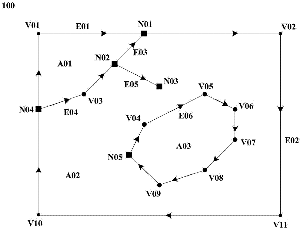
[0052] This embodiment is implemented on a computer, and the arcs and nodes in the GIS topology data set need to be created or loaded on the computer first.

[0053] figure 1 An example GIS topology dataset graph 100 is shown. The GIS topology data set includes 5 nodes, which are N01, N02, N03, N04 and N05; 6 arc segments, namely E01, E02, E03, E04, E05 and E06; 3 regions: A01, A02 and A03 ; V01~V11 in the figure are nodes of the arc segment.

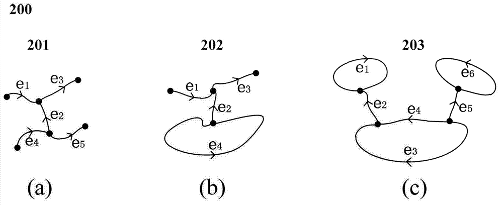
[0054] In order to facilitate further understanding of the GIS topological data sets described in the present invention by those in the relevant fields, figure 2 show figure 1 The GIS topology dataset storage structure 200 is shown. Including node table 201, area table 202 and arc table [namely table 1]. Each row represents a node in the node table 201, and the ID in this table is the unique identification of the node; the value of the arc attribute is the ID of the arc associated with the node, and a node can have one or more As...


PUM


Abstract

The invention discloses a method for generating a polygonal chain with a concentrated topology of a geographic information system. During a polygonal chain search, if one arc section can pass through twice, the arc section is judged to be a hanging arc section, a directed edge corresponding to the hanging arc section can not form the polygonal chain; the polygonal chain is structured by an available directed edge between two directed edges corresponding to the same one hanging arc section in one polygonal chain search; the available directed edge refers to the corresponding directed edge excluding the hanging arc section and the directed edge used for including the polygonal chain as well as the directed edge. The method for generating the polygonal chain with the concentrated topology of the geographic information system is easily carried out; furthermore, generating efficiency of the polygonal chain can be obviously improved.

Description

technical field [0001] The invention relates to a method for generating polygon chains in topological collection of geographic information systems. Background technique [0002] There are two main types of vector data models in Geographic Information System (GIS), namely Spaghetti data model and topological data model (Chu Peng et al.: Introduction to Geographic Information System, Science Press, 2000, P31-43). The basic entity types of the topology model include nodes, arcs and regions, where nodes (nodes) are located at the endpoints of arcs or connecting points of multiple arcs; arcs (edges) are composed of at least two points (i.e. nodes) The curve formed by sequential connection starts from the starting node and ends at the ending node; the area (area) is described by an arc segment, which is a connected domain surrounded by one or more arc segments. The nodes, arcs and regional elements in the topology set based on the topological data model are related to each other,...

Claims


Application Information

Patent Timeline
Patent Type & Authority Applications(China)
IPC IPC(8): G06F17/30
Inventor 邹滨曾永年邱永红
Owner CENT SOUTH UNIV
Why Eureka
Try Eureka