Vehicle-mounted terminal based navigation unit and navigation path correction method

A vehicle-mounted terminal and navigation path technology, applied in the field of navigation, can solve the problem of inaccurate and effective navigation of three-dimensional traffic areas, and achieve the effect of avoiding matching errors

Active Publication Date: 2012-12-19
SHANGHAI PATEO ELECTRONIC EQUIPMENT MANUFACTURING CO LTD
View PDF5 Cites 16 Cited by
  • Summary
  • Abstract
  • Description
  • Claims
  • Application Information

AI Technical Summary

Problems solved by technology

This method is still not accurate enough to navigate the three-dimensional traffic area

Method used


Image

  • Vehicle-mounted terminal based navigation unit and navigation path correction method
  • Vehicle-mounted terminal based navigation unit and navigation path correction method

Examples


Embodiment Construction

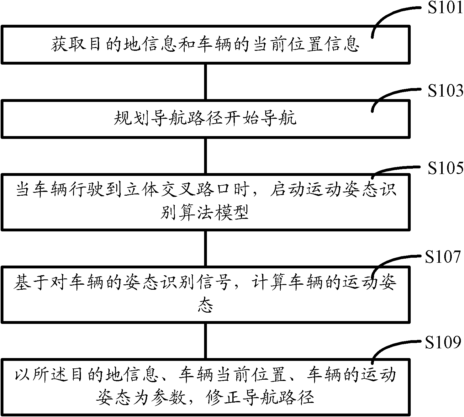
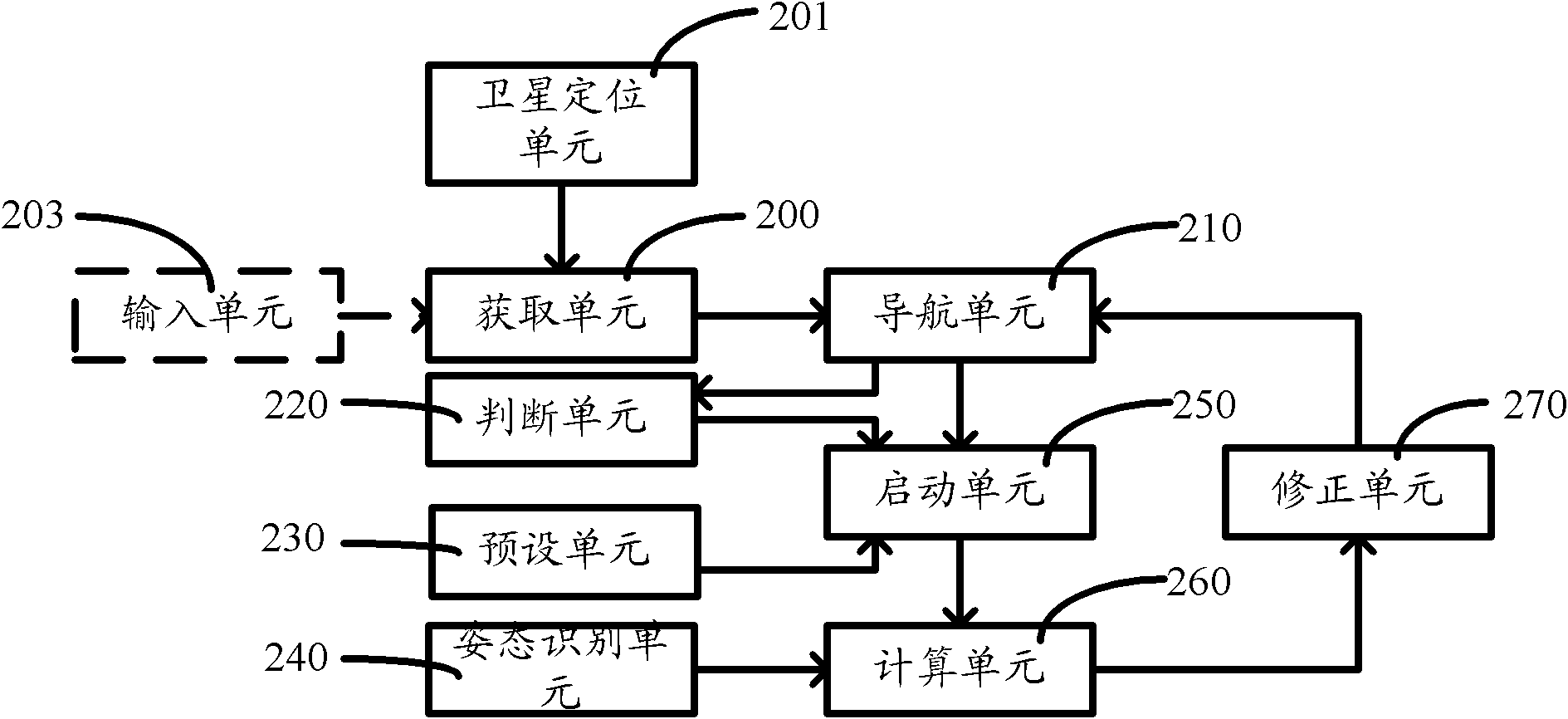
[0036] As described in the background, in the prior art navigation system, it is difficult to distinguish when the projection of the interchange on the plane is a relatively close parallel road section or even a coincident road section, resulting in a matching error and thus a navigation error.

[0037] In view of the above problems, the inventors of the embodiments of the present invention have found after research that in the three-dimensional intersection road section, the motion posture of the vehicle can be judged by calculating the angle between the road and the horizontal ground, so that it can be judged whether the vehicle is on an elevated road, a tunnel or an ordinary road. to match the corresponding road segment.

[0038] After further research, the inventors of the embodiments of the present invention found that the angle between the road and the horizontal ground can be further calculated from gesture recognition signals measured by gesture recognition sensors, suc...


PUM


Abstract

A vehicle-mounted terminal based navigation path correction method comprises the following steps of: acquiring destination information and current position information of a vehicle; planning a navigation path and starting navigation; starting a motion attitude recognition algorithm model when the vehicle drives to a vertical crossroad; calculating the motion attitude of the vehicle based on a vehicle attitude recognition signal; and correcting the navigation path by using the destination information, the current position of the vehicle and the motion attitude of the vehicle as parameters. By the adoption of the vehicle-mounted terminal based navigation unit and the navigation path correction method provided by the embodiment of the invention, navigation of a vertical traffic area can be accurately and effectively performed.

Description

technical field [0001] The invention relates to the field of navigation, in particular to a navigation device of a vehicle-mounted terminal and a method for correcting a navigation path. Background technique [0002] Currently, it is common to use a satellite navigation system, such as a GPS (Global Position System, Global Positioning System), to locate the current location of a vehicle. A navigation device formed by a positioning system combined with electronic map data, such as a car navigator, is also more and more used in people's daily life. [0003] The navigation system in the prior art uses the data provided by GPS, such as longitude and latitude information and heading, to carry out road segment matching. The specific implementation method is: setting the minimum threshold D of the matching road segment; A plurality of line segments, the plurality of line segments constitute a set; scan the set according to the heading, select the road section whose travel directio...

Claims


Application Information

Patent Timeline
Patent Type & Authority Applications(China)
IPC IPC(8): G01C21/34
Inventor 李军
Owner SHANGHAI PATEO ELECTRONIC EQUIPMENT MANUFACTURING CO LTD
Why Eureka
Try Eureka