Distributed geographical file system

A file system, distributed technology, applied in electrical digital data processing, special data processing applications, instruments, etc., to achieve efficient access and achieve the effect of storage and access requirements

Active Publication Date: 2013-01-02
TSINGHUA UNIV
View PDF2 Cites 34 Cited by
  • Summary
  • Abstract
  • Description
  • Claims
  • Application Information

AI Technical Summary

Problems solved by technology

[0006] However, the general distributed file system architecture mainly solves the problem of large file storage, and cannot meet the requirements of Web services for geographic information on efficient storage of large and small files and high concurrent access. According to the r...

Method used


Image

  • Distributed geographical file system
  • Distributed geographical file system
  • Distributed geographical file system

Examples


Embodiment Construction

[0028] In order to make the above objects, features and advantages of the present invention more comprehensible, the present invention will be further described in detail below in conjunction with the accompanying drawings and specific embodiments.

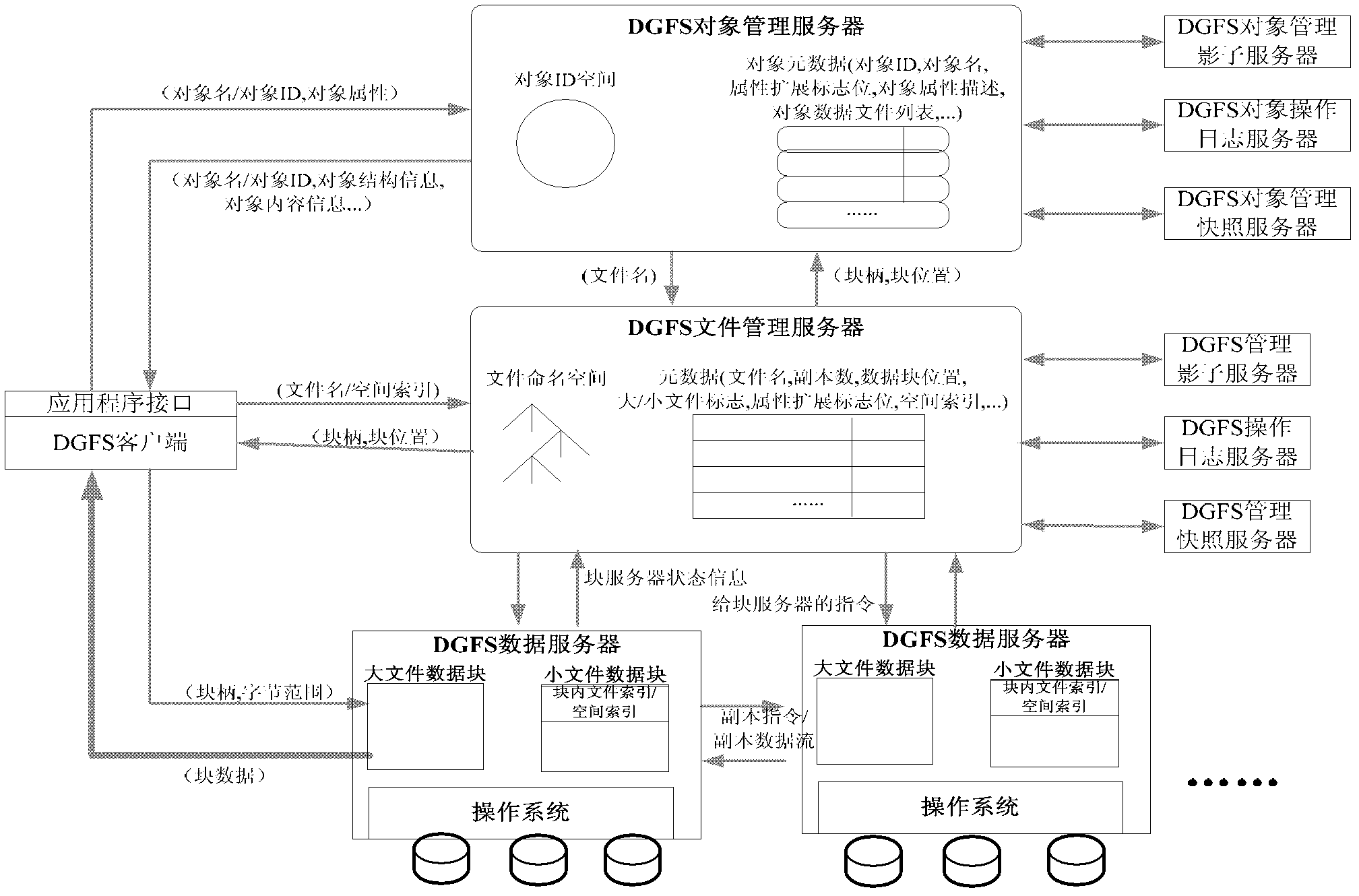
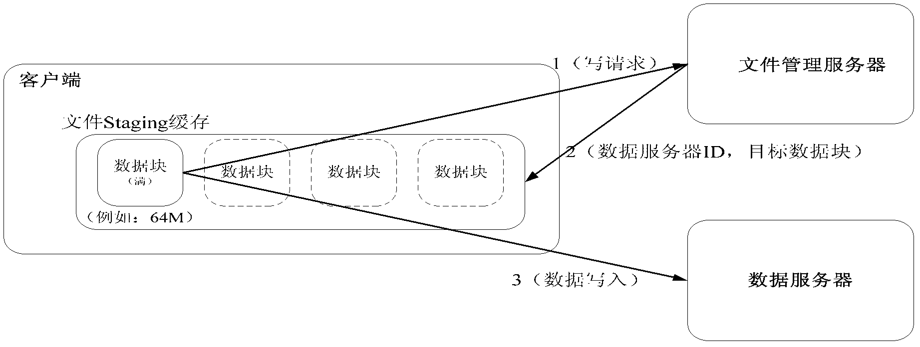
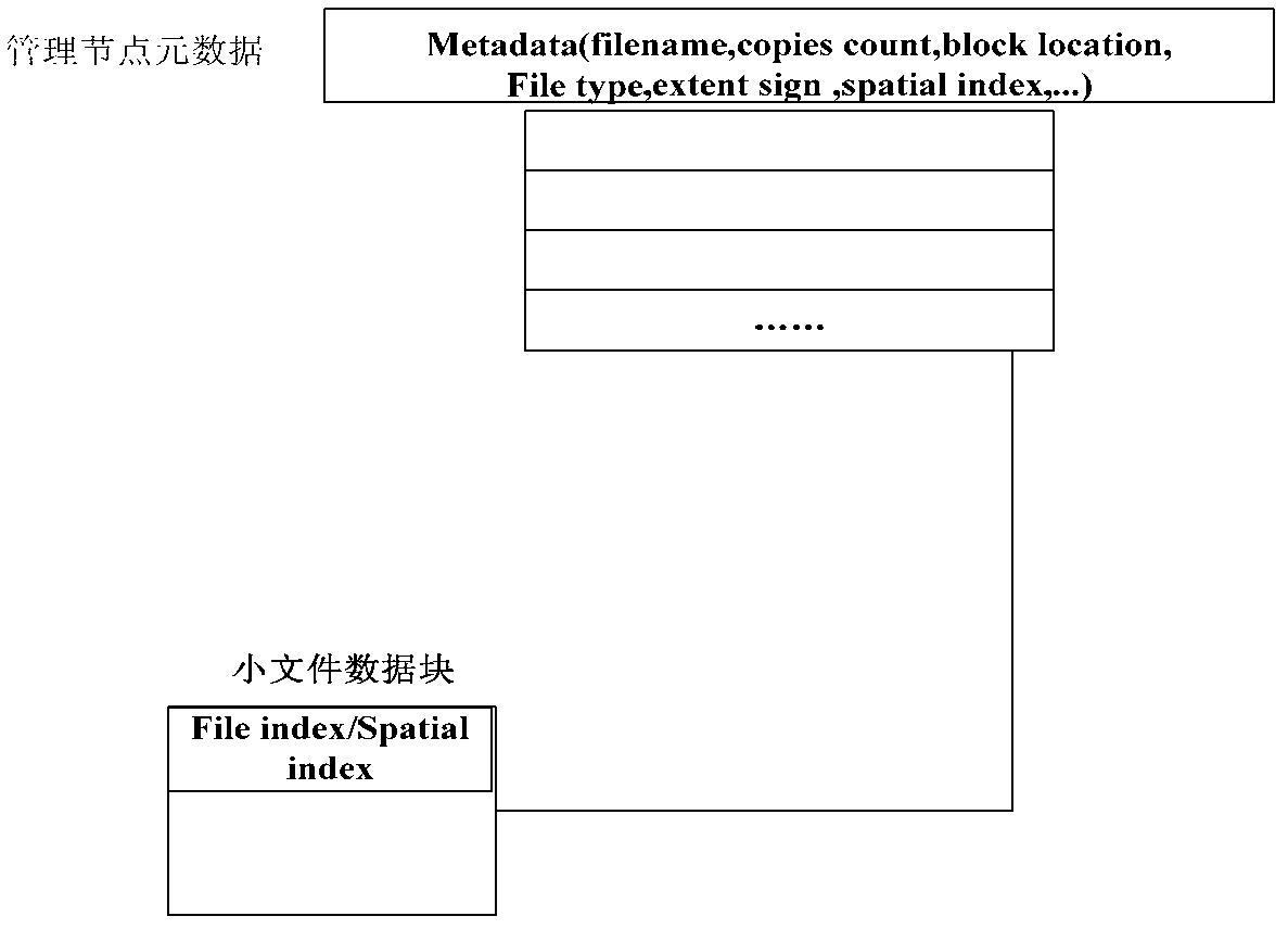
[0029] A distributed geographic file system, comprising: a distributed file system architecture, specifically including a management server node, a data server node, a digital object server node, and a client node; a large file access strategy, which adopts a staging cache strategy when creating a file, The pipeline method is adopted when the copy is generated; the small file access strategy increases the block index in the data server node, and reduces the metadata storage pressure of the management server node through the secondary index of the small file; the geospatial digital object model, so The geospatial digital object model includes geographic digital object identification, digital object metadata, spatial index storage st...


PUM


Abstract

The invention provides a distributed geographical file system. The system comprises a distributed file system framework, a small file access strategy and a geographical space digital object model, wherein the distributed file system framework comprises a management server node, a data server node, a digital object server node and a client node; a staging buffer strategy is adopted by a big file access strategy when a file is built; a production line mode is adopted when a transcript is generated; an in-block index is added in the data server node; element data storage pressure for managing the server node is reduced by performing secondary index on the small file; the geographical space digital object model comprises a geographical digital object mark, digital object element data, a space index storage structure and an algorithm, geographical information version information and file description; and by the interactive design of the distributed file system, all file system element data are managed by the management server node so as to realize communication management between servers as well as between the servers and the clients.

Description

technical field [0001] The invention relates to the technical field of geographic information and data storage, in particular to a distributed geographic file system. Background technique [0002] With the continuous acceleration of the digitalization process and the continuous enrichment of geographic information acquisition methods, geographic information is growing exponentially, and the types of geographic data are more diverse, including large data files exceeding 64MB such as images and videos, and a large number of small files such as pictures and texts. , the data structure is more complex, which brings great difficulty and complexity to the management and sharing of geographic information. [0003] In the field of geographic information, geospatial digital objects refer to geographic information stored in computer systems. The digital object encapsulates the text, image, video, metadata and other forms of multimedia data related to the geographical target and the o...

Claims


Application Information

Patent Timeline
IPC IPC(8): G06F17/30
Inventor 崔纪锋李超张勇胡庆成张桂刚邢春晓
Owner TSINGHUA UNIV
Why Eureka
Try Eureka