Synthetic aperture radar (SAR) Doppler parameter estimation method based on POS and DEM data
A technology of Doppler parameters and data, applied in the field of radar data processing, can solve problems such as low estimation accuracy
- Summary
- Abstract
- Description
- Claims
- Application Information
AI Technical Summary
Problems solved by technology
Method used
Image
Examples
Embodiment Construction
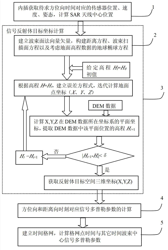
[0043] The present invention solves the ground target position through GPS, IMU (inertial measurement unit) and terrain data, and then solves the Doppler parameter. Specifically, it is implemented through a computer. For the implementation process, see the attached figure 1 , the Doppler parameter estimation is achieved by the following steps:
[0044] Step 1. Determine the corresponding time t at which the Doppler parameters need to be solved, and obtain the GPS antenna position, velocity, acceleration, and attitude parameters of the platform at this time according to the interpolation of the measured values of the GPS and IMU on the carrier aircraft, and the GPS antenna position obtained according to the interpolation[ x GPS ,Y GPS ,Z GPS ], the attitude of the sensor platform, and in the coordinate system of the sensor platform, the offset [eXs, eYs, eZs] of the center of the SAR (Synthetic Aperture Radar) antenna relative to the center of the GPS antenna, calculate the...
PUM
 Abstract
Description
Claims
Application Information
 - R&D
- Intellectual Property
- Life Sciences
- Materials
- Tech Scout
- Unparalleled Data Quality
- Higher Quality Content
- 60% Fewer Hallucinations
Browse by: Latest US Patents, China's latest patents, Technical Efficacy Thesaurus, Application Domain, Technology Topic, Popular Technical Reports.
© 2025 PatSnap. All rights reserved.Legal|Privacy policy|Modern Slavery Act Transparency Statement|Sitemap|About US| Contact US: help@patsnap.com


