Transonic segment barometric altimeter and GPS information two-step fusion method in inertial navigation system

An inertial navigation system, barometric altimeter technology, applied in radio wave measurement systems, satellite radio beacon positioning systems, navigation through velocity/acceleration measurements, etc. And other issues

Active Publication Date: 2015-01-14
NANJING UNIV OF AERONAUTICS & ASTRONAUTICS
View PDF4 Cites 1 Cited by
  • Summary
  • Abstract
  • Description
  • Claims
  • Application Information

AI Technical Summary

Problems solved by technology

[0006] The technical problem to be solved by the present invention is to propose a two-step fusion of transonic barometric altimeter and GPS information for the problem that the atmospheric measurement error changes drastically and seriously affects the performance of traditional inertial / atmospheric damping during transonic maneuvering mission flight method

Method used


Image

  • Transonic segment barometric altimeter and GPS information two-step fusion method in inertial navigation system
  • Transonic segment barometric altimeter and GPS information two-step fusion method in inertial navigation system
  • Transonic segment barometric altimeter and GPS information two-step fusion method in inertial navigation system

Examples


Embodiment Construction

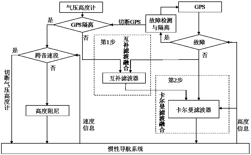
[0058] Below in conjunction with accompanying drawing, the technical scheme of invention is described in further detail:

[0059] The present invention uses barometric altimeter information and GPS information fusion to obtain high-precision altitude information, and the fusion algorithm is mainly divided into the following two steps:

[0060] 1. Complementary filter fusion: Based on the idea of ​​complementary filters, if the altitude information measured by the GPS navigation system without deviation but subject to large noise interference is fused with the altitude information measured by the low-noise but biased atmospheric data system .

[0061] 2. Kalman filter fusion: Build a barometric altimeter / GPS / inertial navigation system combination to realize INS / GPS high-precision integrated navigation based on atmospheric altitude assistance.

[0062] Such as figure 1 As shown, the specific implementation method is as follows:

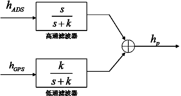
[0063] 1. Complementary filter fusion:

[006...


PUM


Abstract

The invention discloses a transonic segment barometric altimeter and GPS information two-step fusion method used in an inertial navigation system. The method comprises complementary filtering and Kalman filtering. Atmosphere / GPS altitude channel complementary fusion filtering is adopted in complementary filtering, such that barometric altitude value drastic change is eliminated. In Kalman filtering, a barometric altimeter / GPS / inertial navigation system composite navigation system state equation and measurement equation are established, and state optimal estimation of inertial altitude channel can be finally obtained through two-step fusion. According to the invention, the barometric altimeter and GPS form a high redundance and fault detection isolation system, such that the precision of transonic stage altitude value in flight process can be effectively improved, and good conditions are provided for precise navigation and flight control.

Description

technical field [0001] The invention relates to a two-step fusion method for a transonic barometric altimeter and GPS, which can be used to determine the altitude navigation parameters of an aircraft by fusing the measured values ​​of the barometric altimeter and GPS, and belongs to the field of navigation, guidance and control. Background technique [0002] Whether the flight altitude information is accurate or not plays a vital role in the safe flight of the aircraft. Since the altitude channel of the inertial system is unstable, in addition to taking measures to compensate for gravitational (or gravitational) acceleration, it is also necessary to introduce external altitude information and inertial vertical channel information for integration. The height information is damped and the inertial height is corrected. [0003] The essence of the inertial / atmospheric damping system designed based on classical control theory is that the altitude of the inertial navigation syste...

Claims


Application Information

Patent Timeline
Patent Type & Authority Patents(China)
IPC IPC(8): G01C21/16G01S19/49
Inventor 张旭熊智王融吴璇雷庭万刘建业方峥邵慧姚小松刘伟霞张承
Owner NANJING UNIV OF AERONAUTICS & ASTRONAUTICS
Why Eureka
Try Eureka