

Gaussian scale space-based method for constructing semantics of remote-sensing image
A Gaussian scale, remote sensing image technology, used in image analysis, image data processing, instruments, etc., can solve problems such as methods that are difficult to extract, and achieve the effect of convenient implementation.
- Summary
- Abstract
- Description
- Claims
- Application Information
AI Technical Summary
Problems solved by technology
Method used
Image

Examples
Embodiment Construction
[0047] The technical solution of the present invention will be described in detail below in conjunction with the drawings and embodiments.
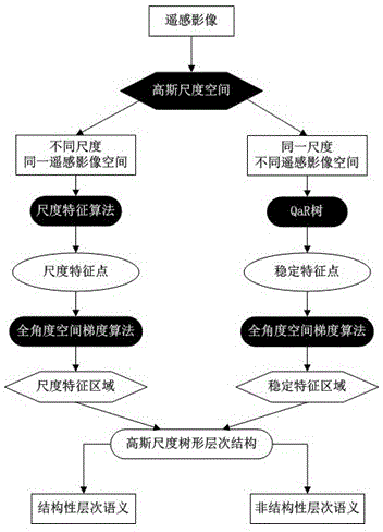
[0048] A method for constructing remote sensing image semantics based on Gaussian scale space proposed by the present invention can be implemented automatically by using computer software technology. In order to set forth the specific implementation of the present invention in more detail, further description is carried out below based on accompanying drawing, embodiment flow process is as follows:
[0049] Step 1. Based on the content of the remote sensing image, the Gaussian scale space of the remote sensing image is established through the Gaussian function.
[0050] The embodiment establishes the Gaussian function g(x, y, n, ε) of the remote sensing image scale space as follows:
[0051] g ( x , ...
PUM
 Abstract
Description
Claims
Application Information