Cache updating method for stripped GIS (Geographic Information System) map elements

A GIS map and strip technology, which is applied in the cache update field of strip GIS map elements, can solve the problems of increasing calculation cost and time overhead, and achieve the effect of clear data volume

Inactive Publication Date: 2013-03-27
INST OF COMPUTING TECH CHINA ACAD OF RAILWAY SCI +1
View PDF4 Cites 30 Cited by
  • Summary
  • Abstract
  • Description
  • Claims
  • Application Information

AI Technical Summary

Problems solved by technology

For GIS map elements distributed in strips such as railways, roads, and rivers, if the cache is updated according to the region or feature range, the content within the range and outside the strip will inevitably be updated, such as image 3 As shown, and this part is unchanged and does not need to be updated, which will inevitably increase unnecessary calculation costs and time overhead

Method used


Image

  • Cache updating method for stripped GIS (Geographic Information System) map elements
  • Cache updating method for stripped GIS (Geographic Information System) map elements
  • Cache updating method for stripped GIS (Geographic Information System) map elements

Examples


Embodiment Construction

[0026] The specific implementation manners of the present invention will be further described in detail below in conjunction with the accompanying drawings and embodiments. The following examples are used to illustrate the present invention, but are not intended to limit the scope of the present invention.

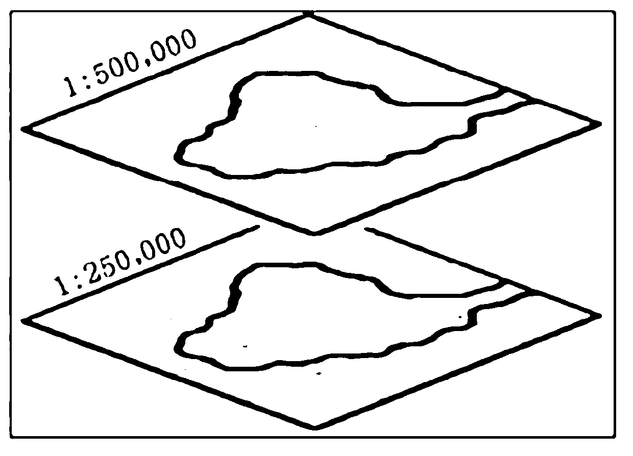
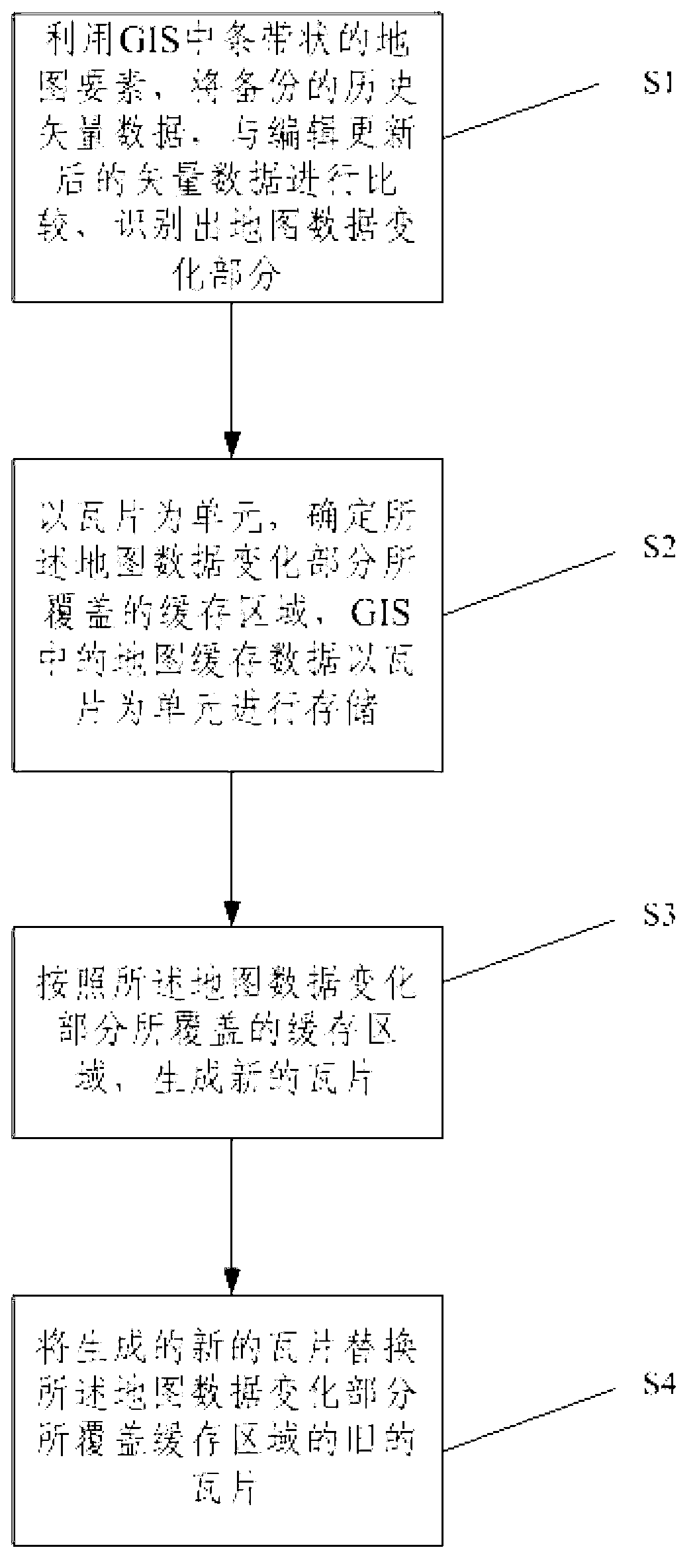
[0027] The invention provides a method for quickly updating the established map buffers under the condition that the map updates are frequently changed, aiming at the GIS map elements of strip-shaped geographic information systems such as railways, roads, and rivers.

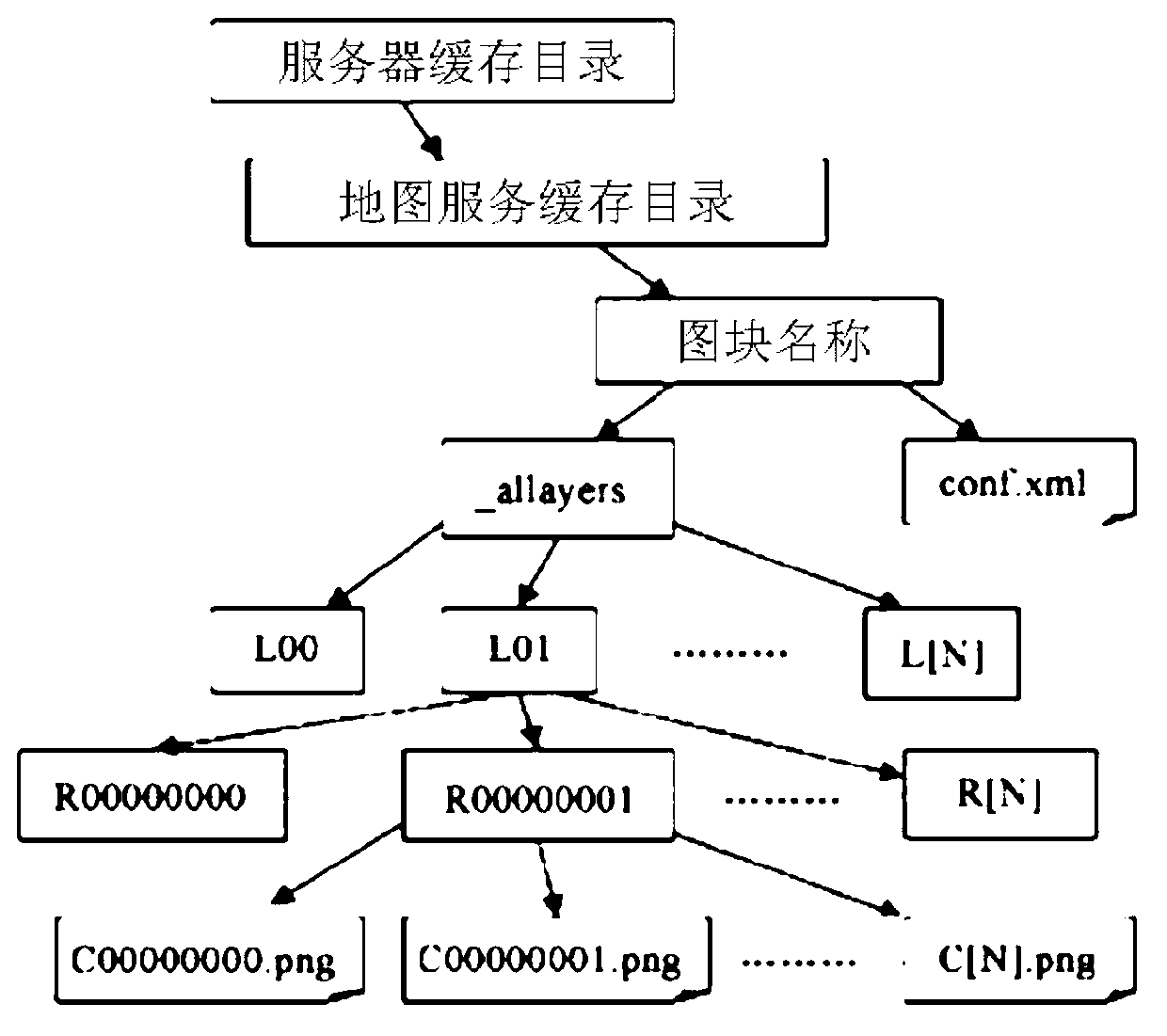
[0028] Before creating a map cache, it is necessary to design the map. In practical applications, Web maps include basemaps and functional thematic layers. The information of the base map does not need to be updated frequently, and a map cache needs to be created; the information of the thematic layer often needs to be updated in real time, and a map cache can be created and updated as needed. Therefore, to...


PUM


Abstract

The invention relates to the technical field of cache updating of stripped GIS (Geographic Information System) map elements and discloses a cache updating method for stripped GIS (Geographic Information System) map elements. The cache updating method comprises the following steps: S1, comparing back-up historical vector data with edited and updated vector data by utilizing stripped map elements in a GIS, so as to identify a map data change part; S2, determining a cache region covered by the map data change part by using a tile as a unit, wherein the map cache data in the GIS is stored by using the tile as the unit; S3, generating a novel tile according to the cache region covered by the map data change part; and S4, replacing the original tile of the cache region covered by the map data change part by the generated novel tile. The quick updating of the GIS global map cache is realized by the cache updating method disclosed by the invention.

Description

technical field [0001] The invention relates to the technical field of cache update of geographic information system (GIS) map elements, in particular to a cache update method of striped GIS map elements. Background technique [0002] When publishing maps, in order to improve browsing performance, the currently popular map caching technology (commonly known as "tile technology") is usually used. That is to say, the map is set to multiple scales, and according to certain mathematical rules, the map of the corresponding scale is cut into pictures of certain specifications and saved in the computer hard disk. When the user accesses the map service through the client browser, the server directly returns the "tile" corresponding to the current map coordinate area, instead of rendering the map in real time according to each request, and creating a picture to send to the client . In this way, the load on the server can be reduced, and the response speed of map browsing can be gre...

Claims


Application Information

Patent Timeline
Patent Type & Authority Applications(China)
IPC IPC(8): G06F17/30
Inventor 王富章李平王英杰卢文龙梁策封博卿吴艳华邹丹
Owner INST OF COMPUTING TECH CHINA ACAD OF RAILWAY SCI
Why Eureka
Try Eureka