Geographical-position related hash virtual geocoding method and system

A geocoding and geographic location technology, applied in the field of hash virtual geocoding methods and systems, can solve problems such as mapping coding that has not been studied

Inactive Publication Date: 2013-03-27
SHENZHEN INST OF ADVANCED TECH
View PDF1 Cites 23 Cited by
  • Summary
  • Abstract
  • Description
  • Claims
  • Application Information

AI Technical Summary

Problems solved by technology

For data retrieval, the file naming method index with no correlation meaning is used, and there is no research on the mapping code related to geographic location

Method used


Image

  • Geographical-position related hash virtual geocoding method and system
  • Geographical-position related hash virtual geocoding method and system
  • Geographical-position related hash virtual geocoding method and system

Examples


Embodiment Construction

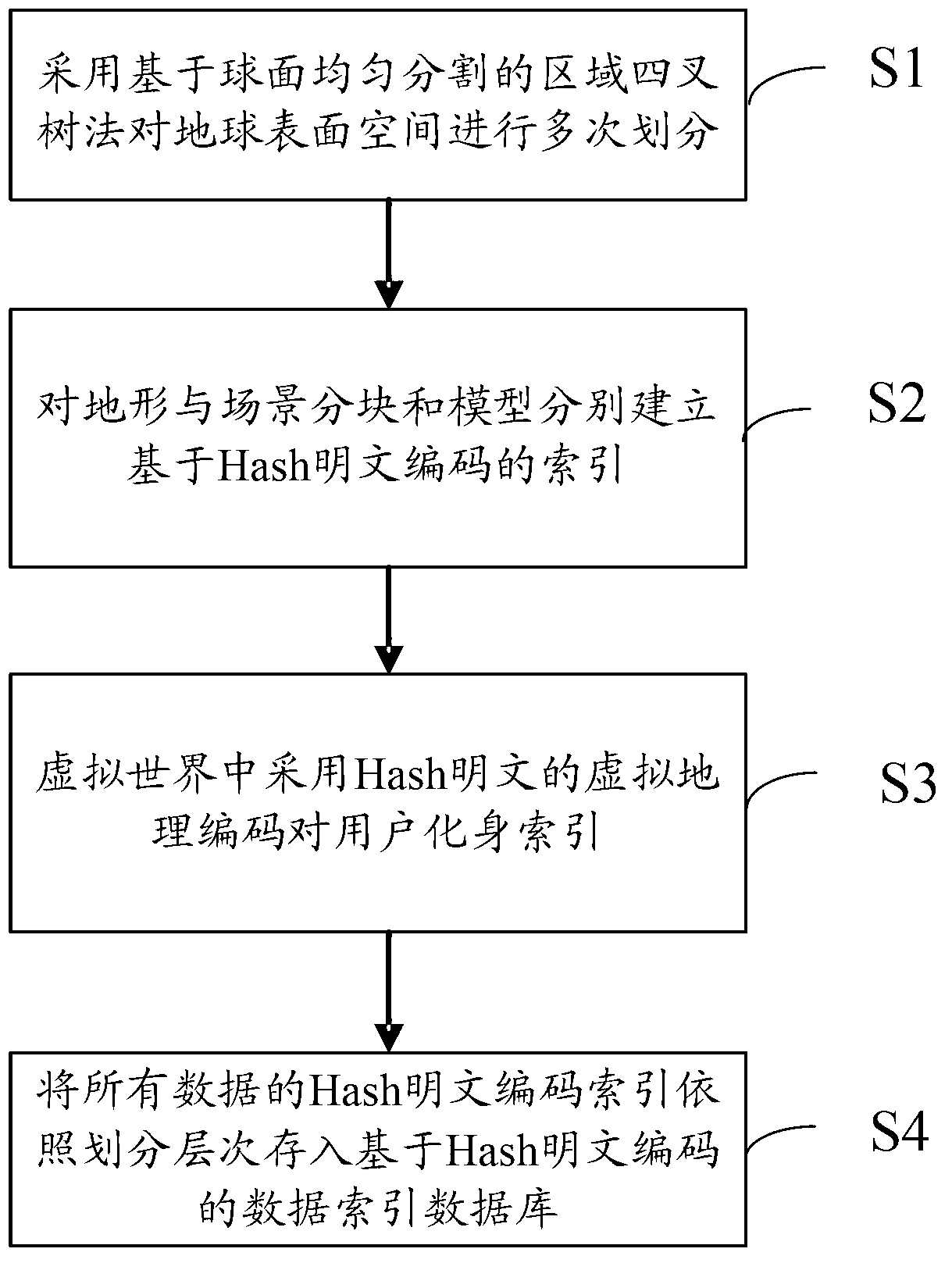
[0028] In order to make the above objects, features and advantages of the present invention more comprehensible, specific implementations of the present invention will be described in detail below in conjunction with the accompanying drawings. In the following description, numerous specific details are set forth in order to provide a thorough understanding of the present invention. However, the present invention can be implemented in many other ways different from those described here, and those skilled in the art can make similar improvements without departing from the connotation of the present invention, so the present invention is not limited by the specific implementations disclosed below.

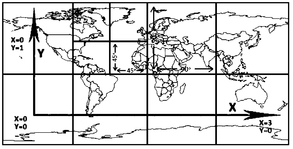
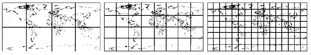
[0029] The present invention proposes a geographic location-related hash virtual geocoding, which encodes and maps the global geographic environment model based on hash (Hash), so that it can be applied to the division of the real world and virtual scenes at the same time, as the overl...


PUM


Abstract

The invention relates to a geographical-position related hash virtual geocoding method and a system. The geographical-position related hash virtual geocoding method comprises the following steps of: diving the earth surface space repeatedly by adopting a region quadtree method based on the uniform division of a spherical surface; establishing indexes based on the hash plaintext coding for a terrain block and a scene block; indexing the user incarnation by adopting the hash plaintext virtual geocoding in the virtual world; and storing the indexes based on the hash plaintext coding of all data into a data index database based on the hash plaintext coding according to the division layer. According to the method, a set of space dividing and indexing mechanism is established and abstracted into a mathematical model, the space dividing and indexing mechanism can be expanded to be used for the real world division and the three-dimensional earth division, and the space dividing and indexing mechanism can be used as a core index data structure in a system to map various objects in the virtual world. Due to the hash plaintext virtual geocoding, the user incarnation and various element models in the three-dimensional earth scene can be indexed, and the relative positions of objects in the virtual world and the real world can be unified.

Description

technical field [0001] The invention relates to the field of geographic information systems, in particular to a hash virtual geographic coding method and system related to geographic location. Background technique [0002] Geocoding, also known as address matching, refers to the process of mapping addresses into geographic coordinates, providing a way to convert geographic location information described as text addresses into geographic coordinates. Virtual geocoding is a coordinate code that indexes addresses mapped with the real world in the virtual world, and is the product of geographic information systems expressed in three dimensions. Geographic information science is a science developed on the basis of geography, cartography, surveying and computer science. The software entity based on it is called geographic information system (GIS). Virtual reality (VR) technology is a mapping of the real world, using computer simulation to generate a three-dimensional virtual spac...

Claims


Application Information

Patent Timeline
Patent Type & Authority Applications(China)
IPC IPC(8): G06F17/30
Inventor 吕智涵陈前冯良炳
Owner SHENZHEN INST OF ADVANCED TECH
Why Eureka
Try Eureka